
Study on the setting-up priority area for protecting the ecological environment of the basin
2014-08-01 01:18PakSongCholZHUWeihong
延边大学学报(自然科学版) 2014年3期
Pak Song Chol,ZHU Weihong
(1.School of Earth Environment Science,Kim Il Sung University,Pyongyang 025512515,DPR of Korea;2.Key Laboratory of Natural Resources of the Changbai Mountain & Functional Molecules (Yanbian University),Ministry of Education,Yanji 133002,China)
1 Principles for the setting-up priority area
Priority area for protecting the ecological environment of the basin is an ecologically functional area,which is selected inside the basin for various purposes and effects,i.e.,to weaken flood process,increase water storage capacity,block the erosion and movement of earth and sand,increase the ecological function of the basin,etc[1].
Priority area,as functional one,selected the riparian protection forest,windshield forest and water conservation forests. These forests and other functional areas inside priority area must be planned through an ecological design.
The principles of setting up priority area are as follows. First is the principle of unity. Pay attention to improving the ecological function of the area as a whole,in the long run,must be resulted in the rational control of water flow. Second is the principle of sustainable development. Ensure the prospective improvement of the whole area beginning from some selected areas,while laying stress on the ecological interest. Third is the principle of protection from disasters. Deal with main damages on the basis of analysis on the existing or possible accidents. Fourth is the principle of suiting to the specific condition of the area. Consider the area’s various natural conditions and different land-use method there[2].
2 Setting up priority area for protecting ecological environment of the basin
The Taedong River adjoins the Chongchon River and many other rivers and valley,their watershed is high in the east and the north east and gets low gradually westwards and southwestwards. The Taedong River’s upstream constitutes a steep slope of 1/17 and its downstream is a very gentle slope of 1/2 500-1/10 000.
The floods in the Taedong River basin vary according to the characteristics and position of the precipitation. Therefore,the previous research classified the floods into 4 categories and defined their features after analyzing the 40-odd floods of in this area[3-5].
The Table 1-4 show the area ratio with the heights above sea level and sloping degrees in Maengsan County on the upstream of the Taedong River and Yangdok County,Sinyang County on its midstream[6].

Table 1 Area ratio with heights above sea level in Maengsan County
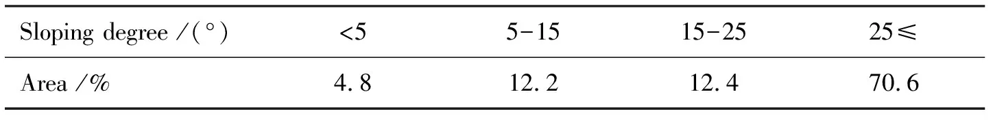
Table 2 Area ratio with sloping degrees in Maengsan County

Table 3 Area ratio with hights above sea level in Sinyang County

Table 4 Area ratio with sloping degrees in Yangdok County
As seen in Table 1-4,slope of above 15° covers 83% of the area in Maengsan County situated in the upstream of the Taedong River and 76.9% in Sinyang County situated in the midstream. It connected with the Sinyang County,which is situated in the west slope of the ridge of Pukdaebong Mountain Range.
Sinyang County occupies the upstream area of the Piryu River,a tributary stream of the Taedong River and most of its area is comparatively steep slopes. Therefore a flood can occur easily if the upstreams of the Taedong River and the Piryu River overflow. This fact shows that maximizing the ecological environmental stability of these areas is the primary solution to the decrease of flood process,the increase of water storage capacity and the prevention of the movement of earth and sand in the whole of the Taedong River basin.
On this basis,this paper presented the reasons why priority area should be set up in the Taedong River basin.
First: Priority area should be marked out the left,considering the area distribution on the both sides of the Taedong River (left: 76.2%,right: 23.8%).
Second: Upstream areas of the Taedong River,Piryu and Nam Rivers,their tributary streams should be selected as priority areas,considering their topographical features,precipitation distribution and the flood characteristics thereof.
Third: The selection of above-mentioned upstream area is based on the priority-area-selecting principles for solving the ecological and disaster problems existing in these areas.
Therefore the areas selected as priority areas are upstream area of the Taedong River and both the upstream areas of the Piryu and Nam Rivers.
The ecological environmental stability state of the counties situated in the upstream of the Taedong River and the Nam and Piryu Rivers,their tributary streams is also studied. The stability state of these areas was defined through calculation with ecology-environment stability index,as a result,their position was decided in the rating range.
Table 5 shows that the changes in their stability ratings of the counties situated in the upstream areas of the Taedong River,Nam and Piryu Rivers.

Table 5 Ecological-environment stability index in the upstream and midstream area of the Taedong Rier in 1991-2010
As seen in the Table 5,upstream area is stable state (Ⅴ-class of stability ratings)at first,but it became low gradually with time and midstream is comparatively stable state (Ⅳ-class of stability rating),but it also became low with time. This is attributable to the many changes in the land-use structure affected by different socio-economic activities during this period.
This paper suggests recovery area results of the damaged forests land to update the present ecological environment stability from class Ⅳ to class Ⅴ in the 4 Counties situated in the Taedong River upstream areas since 2010 (Table 6).

Table 6 Recovery area results of cities and counties (Jongbo)
As explained above,recovery and conservation area results of the forests land of Sinyang County,the upstream area of the Piryu River and Yangdok County,the upstream area of the Nam River were obtained to update their stability state onto class Ⅳ since 2010. On this basis,this paper decided the recovery area results of forests and land to update their stability state into class Ⅴ as priority area (Table 7).

Table 7 Areas of Sinyang County in the upstream of the Piryu River andYangdok County in the upstream of the Nam River (Jongbo)
In the upstream and midstream areas of the Taedong River forest land should be recovered in accordance with their actual conditions and the results investigation of the changed land-use realities in 1991-2010. Priority area should be set up to ensure the ecology-environment protection of the whole basin of the Taedong River,ensure the sustainable development of the ecological function displayed by the basin.
3 Conclusion
On the basis of topographical features of the Taedong River basin and its flood process,this paper suggested priority area,where the damaged forest land should be recovered according to its ecology-environment stability ratings.
:
[1]Kang J J. Collection of Korean Geography (Natural Geography)[M]. Pyongyang: Publishing House of Educational Literature,1996:85-117.
[2]Pak S C. Study on assessment of the regional ecological environment stability based on the main function type of land[J]. Science of Geology and Geography,2013(2):40-42.
[3]Pak S C. Assessment method of quality of regional ecological environment based on ecological function of land[J]. Periodicals of Academy of Science,DPR of Korea,2013(6):53-56.
[4]Costanza R,d’Arge R,Groot R de,et al. The value of the world’s ecosystem services and natural capital[J]. Nature,1997,387(6630):253-260.
[5]Costanza R. Social goals and the valuation of ecosystem services[J]. Ecosystems,2000,3(1):4-10.
[6]栾建国,陈文样.河流生态系统的典型特征和服务功能[J].人民长江,2004,35(9):41-43.
猜你喜欢
小学生作文(低年级适用)(2022年10期)2022-10-31
中学生数理化·七年级数学人教版(2022年11期)2022-02-14
现代临床医学(2021年1期)2021-01-26
艺术评鉴(2020年2期)2020-03-23
小太阳画报(2019年4期)2019-06-11
散文诗(2018年20期)2018-05-06
中国钱币(2016年5期)2016-06-15
少儿科学周刊·少年版(2015年11期)2015-12-17
小说月刊(2015年6期)2015-04-23
中国火炬(2011年10期)2011-07-24
