
An Example of Canal Formation in a Thick Cloud Induced by Massive Seeding Using Liquid Carbon Dioxide
2015-01-05 02:02KIKUROTomineMASAKIShimadaKENJIWakimizuandKOJINishiyama
KIKURO Tomine,MASAKI Shimada,KENJI Wakimizu,and KOJI Nishiyama
1 Department of Earth and Ocean Sciences,National Defense Academy,Yokosuka 239-8686,Japan
2 Faculty of Agriculture,Kyushu University,Hakozaki,Higashiku,Fukuoka 812-8581,Japan
3 Faculty of Engineering,Kyushu University,Motooka,Nishiku,Fukuoka 819-0395,Japan
An Example of Canal Formation in a Thick Cloud Induced by Massive Seeding Using Liquid Carbon Dioxide
KIKURO Tomine1∗,MASAKI Shimada1,KENJI Wakimizu2,and KOJI Nishiyama3
1 Department of Earth and Ocean Sciences,National Defense Academy,Yokosuka 239-8686,Japan
2 Faculty of Agriculture,Kyushu University,Hakozaki,Higashiku,Fukuoka 812-8581,Japan
3 Faculty of Engineering,Kyushu University,Motooka,Nishiku,Fukuoka 819-0395,Japan
The purpose ofthis experiment is to show that massive cloud seeding is effective in mitigating the damage caused by heavy snowfall.In order to show its effect,we attempted to form a canal in a thick convective cloud by massive seeding,and left the parts that were not influenced by the seeding as a reference to show that the canal was formed by the massive seeding only.The seeding was carried out by using an aircraft. The seeding rate and air speed of the aircraft were 35 g s−1and 115 m s−1,respectively.The flight course for seeding was selected to be parallel to the wind direction to ensure that the dispersed liquid carbon dioxide did not influence both sides of the course.The results show that a part of the radar echo observed from onboard beneath the seeding track was weakened and divided the radar echo into two parts 20 minutes after the cloud top and the bottom were seeded,and distribution of rainfall rate on the ground from the target cloud was confirmed to be divided into two parts 24 minutes after the seeding.The target cloud was torn along the seeding track,and we could see the sea surface through the break in the cloud.Canal formation occurred in the cloud along the seeding track.Clouds and snowfall were left on both sides of the canal. The results show that supercooled liquid cloud particles along the seeding track evaporated to form larger precipitable particles which grew and fell rapidly.
heavy snowfall,weather modification,aircraft,artificial cloud seeding
1.Introduction
Artificial cloud seeding has been expected to be an efficient technique for weather modification and the redistribution of rainfall and snowfall.This technique has been widely used to enhance rainfall intensity.The augmentation of convective rainfall has been studied in many works(e.g.,English and Marwitz,1981;Woodley et al.,1982;Rosenfeld and Woodley,1989).However,Hobbs and Politovich(1980)described that care had to be taken not to overseed for the augmentation of rainfall amount.Moreover,they showed some doubts on significant increases in precipitation from cumulus complexes due to artificial seeding.Marwitz and Stewert(1981)also described that overseeding could dissipate the cloud and the reason was not known yet.In addition,randomized experiments have been carried out with inconclusive results(e.g.,Rangno and Robbs,1995;Dennis and Orville,1997;Rangno and Hobbs,1997;Rosenfeld et al.,1997;Bruintjes,1999;Silverman,2001;Garstang et al.,2004;Dai et al.,2007).Zoljoodi and Didevarasl(2013)investigated the result of the cloud seeding over Yazd Province in Iran during February-April of1973-1997 to confirm the success of that cloud seeding project.Recently,to respond to extreme water shortages in Southeast Queensland in Australia,the potential for cloud seeding to enhance rainfall was explored.During the course of the program,it became clear that there was great variability in the natural cloud systems in Southeast Queensland region,and understanding that variability would be necessary be-fore any conclusions could be made regarding the impact of cloud seeding(Tessendorf et al.,2012).
The other aims of glaciogenic cloud seeding include hail suppression and controlling the snowfall in supercooled clouds.The snowfall from a heavily seeded cloud was investigated by Holroyd and Jiusto (1971)with the aim of making snow advect farther inland than normal.They observed an increase in the snow crystal concentration,and crystals with thick plates and solid columns were observed instead of rimed snow crystals.The results indicated that the seeded cloud had a dry environment.Miller et al. (1975)conducted a randomized cloud seeding project to reduce hail damage and showed that measurements of hail energy and hail depth derived from passive hail indicators on seed days were not so different from those on no-seed days,but the seeded storms had,on average,lower radar reflectivity factors,smaller hailstones, and lower hail energies.The concepts of hail suppression are known to ensure“beneficial competition”and“premature rain out”.Hailstorm seeding experiments were performed in Alberta,Canada,from 1980 to 1985(Stewart,1986).The results showed that the number of ice crystals in the seeded clouds was significantly greater than those in the unseeded clouds at their comparative stages in cloud life.The large number of ice crystals was initially observed only in a very small part of the cloud,but they spread and grew with time.When the seeded feeder clouds had sufficient distance from the main storm,the seeding was considered to have encouraged the early formation of precipitable particles.However,they failed to show clear evidence of the seeding in radar echo due to sensitivity of the radar.
The results of a numerical simulation for the hail suppression experiments showed that the seeding produced many ice crystals,which spread throughout the cloud and grew with time,and that the seeded feeder cloud precipitated earlier than the unseeded feeder cloud.Furthermore,temporary beneficial competition decreased liquid water,which suggested the necessity of continuous seeding to maintain this competition(Stewart,1986).Ikawa et al.(1991)conducted experiments to investigate the sensitivity of the amplification of various ice nucleation rates to determine the effects of an increase in the number concentration of ice crystals on precipitation.They showed that increasing the number concentration of ice crystals to 105-106m−3caused the mass and amount of snow to increase and the radar reflectivity to decrease.In addition,it was shown that further increasing the number concentration of ice crystals to 107m−3resulted in the suppression of precipitation,glaciation of clouds with little cloud water,and the suppression of abundant snow in the air.
The above described experimental and numerical results indicate the possibility of suppressing precipitation and controlling heavy snowfall by massive seeding.When it comes to seeding experiments in relatively thin clouds to increase rainfall amount,it is well known that an extensive stratus cloud with a thickness of 400 m can be suppressed to make an open lane by dry ice seeding at a rate of 180 g km−1(Schaefer,1946).Similar investigations were carried out by Coons et al.(1948).They seeded 16 clouds that were not detected by radar echoes prior to seeding.Their objective was to cause 15 of the 16 clouds to produce trivial amounts of precipitation.They reported that a significant dissipation tendency was observed after their developing at the seeding stages. Heymsfield et al.(2011)investigated hole-punch and canal clouds in thin clouds about 150-m thick to show that inadvertent seeding by aircraft can form such canals.Recently,Maki et al.(2013,2014)reported that cloud disappeared after cloud seeding by using a liquid carbon dioxide seeding rate of 50 g km−1. They targeted clouds about 1400-m thick.These experiments are not classified as massive seeding experiment and these holes and dissipated clouds seem to be results of snowfall formed by Wegener-Bergeron-Findeisen(WBF)mechanism(Korolev,2007)in thin clouds with weak updraft.Then,the tendency of a cloud to dissipate after it is seeded during its developing stage,or during a different stage,is considered to be a frequently observed phenomenon in thin clouds.
For thick clouds,massive seeding is expected to be able to control distributions of snowfall amount or to suppress hail amount.However,evidence of con-trolling distributions of snowfall amount or hail suppression due to massive seeding has not been discussed enough.In general,hail suppression is important for agriculture and the suppression of heavy snowfall is important for city traffic and rural life,since heavy snowfallcan cause ruralroads to close and isolate small villages.Thus,we have conducted an experiment to show that canalcan be formed even in a thick cloud by massive seeding so that further studies can be carried out to mitigate the damages caused by heavy snowfall.
2.Seeding experiment
A massive seeding experiment was conducted over the Sea of Japan on 14 January 2014(Fig.1)to investigate canalformation in thick clouds.The experiment was carried out by using an aircraft(UP-3C;Kawasaki Heavy Industries,Ltd.)belonging to Air Development Squadron 51 of the Japan Maritime Self Defense Force.Liquid carbon dioxide(hereafter abbreviated as LCO2)was sprayed from a nozzle installed in a freefall chute under the tail of the aircraft.The LCO2evaporated rapidly,which caused the surrounding air to cool to about-80℃when released into a standard atmosphere and the water vapor in the cooled air experienced deposition instantaneously to generate 1013ice crystals per 1 g of LCO2(Fukuta et al.,1971). Cloud droplets around the evaporating LCO2might freeze,but number density ofthe frozen cloud droplets was estimated to be negligible.The ice crystals could grow to at least 10µm in radius 30 s after generation (Fukuta and Takahashi,1999).
The area for the experiment is enclosed by a square in Fig.1.LCO2was sprayed in the cloud top from 13:24 to 13:26 JST(Japan standard time) and in the cloud bottom from 13:30 to 13:32 JST. Large precipitation particles,which might be aggregated snow or graupel,were observed near the cloud base when they hit the window glass.The seeding rate was 35 g s−1and the air speed of the aircraft was 115 m s−1.The purpose of this experiment was to form canal and to leave the other parts without influences of the LCO2as a reference to show the effects of massive seeding.Then,both seeding tracks were set to be nearly parallel to the wind direction at the seeding altitude so that the ice crystals that formed due to the seeding did not spread across both sides of the seeding track.Wind directions and speeds were 271.5°and 15.6 m s−1at the cloud top and 278.3°and 6.8 m s−1at the bottom,respectively.The direction and speed of the cloud movement were 269°and 12.4 m s−1,respectively.These seeding tracks were directed to 264°.Seeding is expected to increase snow mixing ratio through deposition on ice crystals by the WBF mechanism and it is known that seeding in a lower part of a cloud is more effective than in an upper part(Ikawa,1991).However,seeding was carried out in both levels in this experiment to make sure of the weakening of the radar echo or dissipation ofa part of the target cloud.
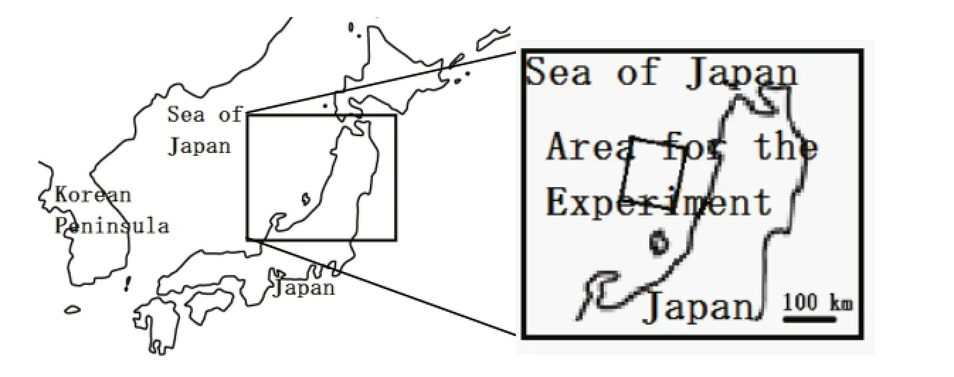
Fig.1.Location of the artificial seeding experiment.The target area for the experiment is enclosed by a square in the right figure.
An onboard observation of the X-band target radar echo,which appeared in the display since 13:11 JST,is shown in Fig.2.The aircraft was at the center of the circle in Fig.2.In the display of the radar echo,north is always facing up.The western edge of the circle was attached to the eastern edge of the tar-get radar echo,which was located about 2 km from the aircraft.The heading is shown by a blue straight line in the figure and it was set to split the radar echo into two parts.The target cloud was 3-km thick with the cloud base at 0.6-km AGL(above ground level), and the seeding levels were 2.6 and 0.5 km.The altitudes of the cloud top and bottom were measured by the aircraft’s altimeter when it flew near the top and the bottom.The open air temperatures in cloud free atmosphere on both levels of the cloud’s top and bottom were-19 and-7℃,respectively.The temperature was obtained by correcting that indicated by the thermometer in the Pitot tube of the aircraft.A temperature profile measured by the aircraft is shown in Fig.3.The vertical temperature gradient was about 10.8℃km−1between 0.3 and 0.76 km,which was a little larger than that of the dry adiabatic lapse rate to show that the lower atmosphere was unstable. The vertical temperature gradient was 3.4℃km−1between 1.4 and 3.7 km,which was considered to be a rather stable atmospheric layer.The sea surface temperature(SST)surrounding the experimentalarea was from 12 to 13℃according to daily SSTs on 14 January 2014 by the Japan Meteorological Agency,which was very warm due to the Tsushima warm current.The warm sea surface and the layer between 0.3 and 0.76 km with the temperature gradient were a little unstable,and it showed that the layer was well mixed (Stull,1997).Therefore,convection was active during the experimental period and many stratocumuli were observed around the experimental area.The growth of these convective clouds seemed to be inhibited in the stable layer between 1.4 and 3.7 km.
A photograph of the target cloud,which is enclosed by a circle,is shown in Fig.4.In the photograph west is facing up.The cloud seemed to be in its developing stage,since its cloud top was rising.Many roughly shaped stratocumuli were observed around the target cloud,which were assumed to contain a significant amount of supercooled liquid water. They were cumuli called“embedded cumulus”(Hobbs et al.,1980).Many of these clouds were adequate for artificial cloud seeding.These cloud conditions are frequently observed over the Sea of Japan in winter.

Fig.2.Radar echo intensity distribution on board at 13:24:44 JST,and the north direction was set to be always upward.The center of the circle indicates the position of the aircraft and the blue straight line from the center indicates the nose direction.The symbols on the target radar echo in the figure are markers for the echo.
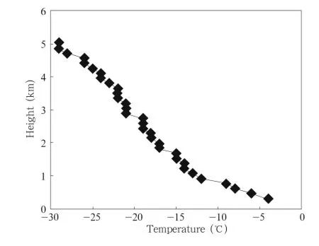
Fig.3.Profile of air temperature.
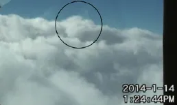
Fig.4.Cloud picture in front of the aircraft at 13:24:44 JST.The target cloud is the center cloud enclosed by a circle.In the photograph,west is facing up.
3.Results
Distributions of rainfall rate on the ground radar from the national synthesis system(Miyagi et al.,2012)at 13:20 and 13:30 JST are shown in Figs.5a and 5b,respectively.The system is composed of C-band radar,X-band radar,and some ground truth. Position of the nearest C-band radar(Akita radar)of the target cloud is indicated in Fig.5a.The blue and brown lines in Fig.5 indicate the seeding tracks near the cloud top and bottom,respectively.Numerous snow clouds were located around the experimental area,but less rainfall rate from the target cloud enclosed by a circle in Fig.5a was observed at 13:20 JST. The rainfallrate increased suddenly during this period to show development of the target cloud,as shown by the figures.Radar echo of the target cloud observed onboard was reported by the radar operator to have slightly intensified after the seeding,but we could not observe such intensification clearly.Rainfall rate in the ground area under the target cloud were strengthened and widened,respectively,from 13:30(Fig.5b) to 13:40(Fig.6)JST,14 min after the cloud top was seeded.
The distribution of the radar echo intensity as observed onboard the aircraft at 13:46:25 JST,20 min after the cloud top was seeded,is shown in Fig.7. The target radar echo is enclosed by a white circle. The radar echo intensity that had been beneath the seeding track was weakened and the radar echo was clearly divided into two parts(northern and southern parts).Distribution ofthe rainfallrate from the target cloud at 13:50 JST,24 min after the seeding,is shown in Fig.8.Distribution of the rainfall rate under the target cloud was divided into two parts as described in the upper radar echo(Fig.7).
We then flew our aircraft towards the target cloud to observe what happened to the cloud.The distribution of the radar echo intensity observed onboard the aircraft at 13:54:38 JST is shown in Fig.9.The aircraft was positioned just over the break of the target cloud and a westward heading was flown,as shown in Fig.9.A photograph that was taken from the front of the aircraft is shown in Fig.10.The cloud was clearly separated and the sea surface could be observed through the break of the cloud.Roughly shaped stratocumuli were left on both sides of the break,and snowfall was observed along the edges of the cloud break.A thin cloud,which is enclosed by a rectangular box in Fig.10,was left over the break.The cloud was stratiformed and considered to consist of ice crystals produced by the seeding.Rainfall rate from the target cloud increased and moved eastward,as shown in Fig.11.
Furthermore,constant altitude PPI(CAPPI)of radar at Akita was investigated to understand vertical structure of radar echo of the target cloud and its time evolution.Radar echo intensities of the target cloud at 0-,1-,2-,and 3-km levels were strengthened suddenly between 13:30 and 13:40 JST,with increase of rainfall rate from the target cloud.However,at 13:50 JST,distribution of radar echo intensity of the target cloud was divided into two parts only at 3-km level,same as distribution of the rainfall rate.The reason is not understood as to why radar echo intensity distributions of the target cloud at the other levels were not divided into two parts.
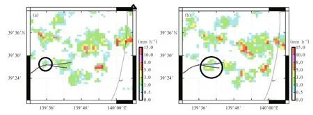
Fig.5.Distributions of rainfall rate at(a)13:20 and(b)13:30 JST.Rainfall rate from the target cloud is enclosed by black circles in(a)and(b).The black triangle on the right upper corner in(a)represents radar position.The blue and brown lines in the figures indicate seeding courses at the cloud top and bottom,respectively.
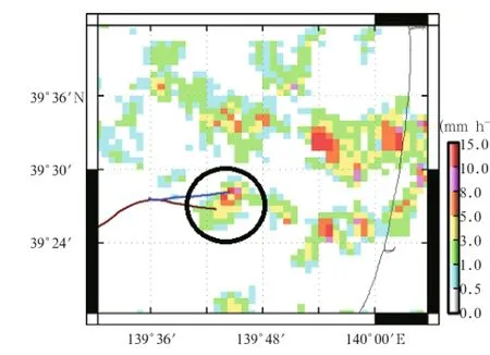
Fig.6.As in Fig.5,but at 13:40 JST.

Fig.7.Distribution of radar echo intensity at 13:46:25 JST.The radar echo into which liquid carbon dioxide was sprayed is enclosed by a white circle.
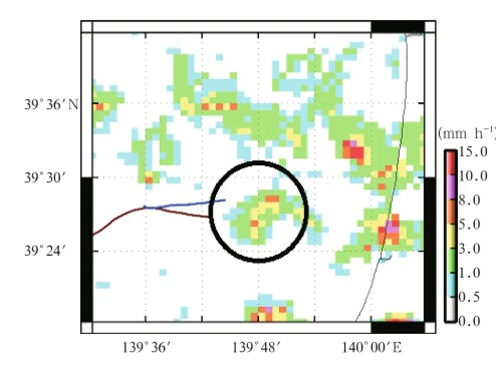
Fig.8.As in Fig.5,but at 13:50 JST.

Fig.9.As in Fig.7,but at 13:54:38 JST.
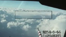
Fig.10.Cloud distribution in front of our aircraft at 13:54:38 JST.The rectangular shows thin ice cloud.
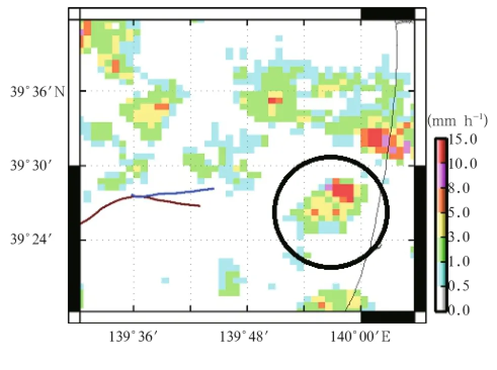
Fig.11.As in Fig.5,but at 14:10 JST.
The intensification ofthe radar echo and strengthened rainfall rate on the ground from the target cloud between 13:30 and 13:40 JST,just after the seeding,may be results of the developing cloud affected by the seeding.The radar echo intensity and rainfall rate from the target cloud were expected to increase naturally because we selected a developing cloud as a target cloud of the seeding,and the seeding is guessed to promote the increase.Cloud ice particles formed in the seeding track had to grow by deposition and supercooled liquid cloud particles there were expected to evaporate through the WBF mechanism.Snow was expected to form by auto conversion or deposition from the grown enough cloud ice to intensify the radar echo or to increase rainfall rate from the target cloud. The“premature rain out”was described as a phenomena that precipitation process was started earlier in the lifetime of a cloud than normal by glaciogenic seeding(Stewart,1986).In this experiment,cloud with radar echo or with precipitation was seeded and the increased rainfall rate from the cloud might be influenced by the seeding.If the increased rainfall rate is affected by the seeding,the increase will be called a kind of“premature rain out”.
Then,the radar echo intensity observed onboard the aircraft,which had been beneath the seeding track, was weakened,the distribution of the rainfall rate under the target cloud was divided into two parts, the target cloud was torn along the seeding track, and a thin stratified cloud was left over the break. The results show that supercooled liquid cloud particles along the seeding track vaporized out to form larger precipitable particles.These larger particles must have fallen rapidly and cleared away other cloud particles,because the cloud was torn into two parts about 20 min after the cloud was seeded.The stratified thin cloud left over the break in Fig.10 was floating apart from surrounding clouds composed of liquid cloud particles,and cloud ice particles in the thin cloud seemed to be able to grow no more.The thin cloud may be composed of cloud ice particles produced by the seeding and not grown up well without sufficient mixing with liquid cloud particles.The“beneficial competition”mechanism seems to work in a part of the target cloud.
Under above speculations,the target cloud was 3-km thick and large precipitation particles were observed near the cloud base in the experiment as described before.When the seeded cloud was thick,including enough liquid cloud particles to form rain or graupel without any seeding as in the case,cloud ice particles formed by the seeding were guessed to have the possibility to affect precipitable particles.Snow particles might accrete cloud ice particles or rain might accrete them to form graupel particles rapidly as described in the cloud model described by Lin et al. (1983).
Rainfall rate on the ground from the target cloud continued to increase in intensity and area from 13:20 JST to just before the cloud was seeded.After the cloud was divided into two parts,the southern part dissipated while the northern part continued to grow. At 14:20 JST,the northern part began to dissipate slowly from the coast towards inland.The heavy seeding in this experiment was not able to prevent the rainfall rate from increasing or to stop the stratocumulus from developing,as described above.
This seems to have been the case for a majority of the stratocumulus that was not affected by the seeding,because the experiment was set to dissipate only a small part of the cloud,since the objective was to show that the dissipation of the cloud or weakening of the radar echo was due to only the seeding.Thus,if LCO2can be sprayed into the appropriate area of a cloud at the proper time to dissipate the radar echo sufficiently,it may be expected to weaken the radar echo intensity of the cloud just before the cloud landing,which can help mitigate the damages caused by snowfall.
However,if enough LCO2was seeded,it might be difficult to prevent the stratocumulus development thoroughly because the development was supported by updraft in the cloud and the updraft was expected to be slightly influenced by the large snow or graupelparticles formed through the seeding.The updraft of 4 m s−1in maximum was observed by Sakakibara et al. (1988)in a snow-band over Sea of Japan in winter. Such strong updraft will reconstruct the dissipated stratocumulus in a short period.The massive seeding in our study might be able to redistribute snowfall amount temporarily.Quantitatively,the strongestrainfall intensity from the target cloud was from 8 to 10 mm h−1at 13:40 JST(Fig.6)and it decreased to between 5 and 8 mm h−1at 13:50 JST.Area of rainfall rate stronger than 5 mm h−1decreased from 1.5 km−2at 13:40 JST to 0.75 km−2at 13:50 JST.All clouds near the coast of a local area must be,therefore,dissipated temporarily through massive seeding before their landing to mitigate damages from heavy snowfall in the local area.
4.Conclusion
This is a case study to show that thick cloud can be affected to make canal by massive seeding.A stratocumulus that was 3-km thick with a radar echo was seeded heavily with LCO2.Radar echo of the target cloud observed onboard our aircraft beneath the seeding track was weakened to divide the radar echo into two parts.LCO2that was sprayed appeared to have initiated the WBF mechanism,which dissipated the cloud along the seeding track.The results show that massive seeding can weaken or dissipate a stratocumulus temporarily and has the possibility to decrease the damages caused by heavy snowfall.
As described before,some authors have reported possibility of killing cloud or suppressing hail through heavy cloud seeding.But no one has ever presented weakened radar echo or canal in thick cloud made by cloud seeding.Conviction that massive cloud seeding is effective for suppression of heavy snowfall will be confirmed more strongly than before by presenting an example of a weakened radar echo by massive seeding as shown in this study.
REFERENCES
Bruintjes,R.T.,1999:A review of cloud seeding experiments to enhance precipitation and some new prospects.Bull.Amer.Meteor.Soc.,80,805-820.
Coons,R.D.,E.L.Jones,and R.Gunn,1948:Second partial report on the artificial production of precipitation:Cumuliform clouds,Ohio,1948.Bull. Amer.Meteor.Soc.,29,544-546.
Dai Jin,Yu Xin,D.Rosenfeld,et al.,2007:Microphysical effects of cloud seeding in supercooled stratiform clouds observed from NOAA satellite.Acta Meteor. Sinica,21,224-233.
Dennis,A.S.,and H.D.Orville,1997:Comments on“A new look at the Israeli cloud seeding experiments”. J.Appl.Meteor.,36,277-278.
English,M.,and J.D.Marwitz,1981:A comparison of AgI and CO2seeding effects in Alberta cumulus clouds.J.Appl.Meteor.,20,483-495.
Fukuta,N.,W.A.Schmeling,and L.F.Evans,1971:Experimental determination of ice nucleation by falling dry ice pellets.J.Appl.Meteor.,10,1174-1179.
Fukuta,N.,and T.Takahashi,1999:The growth of atmospheric ice crystals:A summary of findings in vertical supercooled cloud tunnel studies.J.Atmos. Sci.,56,1963-1979.
Garstang,M.,R.Bruintjes,R.Serafin,et al.,2004: Weather modification:Finding common ground. Bull.Amer.Meteor.Soc.,85,647-655.
Heymsfield,A.J.,G.Thompson,H.Morrison,et al., 2011:Formation and spread of aircraft-induced holes in clouds.Science,333,77-81.
Hobbs,P.V.,M.K.Politovich,and L.F.Radke,1980: The structures of summer convective clouds in eastern Montana.I:Natural clouds.J.Appl.Meteor.,19,645-663.
Hobbs,P.V.,and M.K.Politovich,1980:The structures of summer convective clouds in eastern Montana. II:Effects of artificial seeding.J.Appl.Meteor.,19, 664-675.
Holroyd III,E.W.,and J.E.Jiusto,1971:Snowfall from a heavily seeded cloud.J.Appl.Meteor.,10,266-269.
Ikawa,M.,H.Mizuno,T.Matsuo,et al.,1991:Numerical modeling of the convective snow cloud over the sea of Japan.Precipitation mechanism and sensitivity to ice crystal nucleation rates.J.Meteor.Soc. Japan,69,641-667.
Korolev,A.,2007:Limitations of the Wegner-Bergeron-Findeisen mechanism in the evolution of mixedphase clouds.J.Atmos.Sci.,64,3372-3375.
Lin,Y.-H.,R.D.Farley,and H.D.Orville,1983:Bulk parameterization of the snow field in a cloud model. J.Climate Appl.Meteor.,22,1065-1092.
Maki,T.,O.Morita,Y.Suzuki,et al.,2013:Artificial rainfalltechnique based on the aircraft seeding ofliquid carbon dioxide near Miyake and Mikura islands, Tokyo,Japan.J.Agric.Meteor.,69,147-157.
Maki,T.,O.Morita,Y.Suzuki,et al.,2014:Artificial rainfall experiment by seeding liquid carbon dioxide above the Izu islands of Tokyo on 14 March 2013.J. Agric.Meteor.,70,199-211.
Marwitz,J.D.,and R.E.Stewart,1981:Some seeding signatures in Sierra storms.J.Appl.Meteor.,20, 1129-1144.
Miyagi,H.,T.Iriguchi,D.Satoh,et al.,2012:Improvement of analysis rainfall,precipitation short time forecast,and precipitation nowcasting.Training text of forecast technology in Japan Meteorological Agency,18,108-121.(in Japanese)
Miller Jr.,J.R.,E.I.Boyd,R.A.Schleusener,et al., 1975:Hail suppression data from western North Dakota,1969-1972.J.Appl.Meteor.,14,755-762.
Rangno,A.L.,and P.V.Robbs,1995:A new look at the Israeli cloud seeding experiments.J.Appl.Meteor.,34,1169-1193.
Rangno,A.L.,and P.V.Hobbs,1997:Reply.J.Appl. Meteor.,36,279.
Rosenfeld,D.,and W.L.Woodley,1989:Effects of cloud seeding in West Texas.J.Appl.Meteor.,28,1050-1080.
Rosenfeld,D.,A.L.Rangno,P.V.Hobbs,1997:Comments on:A new look at the Israeli cloud seeding experiments.J.Appl.Meteor.,36,260-276.
Sakakibara,H.,M.Ishihara,and Z.Yanagisawa,1988: Squall line like convective snowbands over the Sea of Japan.J.Meteor.Soc.Japan,66,937-953.
Schaefer,V.J.,1946:The production of ice crystals in a cloud of supercooled water droplets.Science,104, 457-459.
Silverman,B.A.,2001:A critical assessment of glaciogenic seeding of convective clouds for rainfall enhancement.Bull.Amer.Meteor.Soc.,82,903-923.
Stewart,R.W.,1986:Weather modification in Alberta. Summary report and recommendations.
Stull,R.B.,1997:An Introduction to Boundary Layer Meteorology.Springer,Netherlands.17 pp.
Tessendorf,S.A.,R.T.Bruintjes,C.Weeks,et al.,2012: The Queensland cloud seeding research program. Bull.Amer.Meteor.Soc.,93,75-90.
Woodley,W.L.,J.Jordan,A.Barnston,et al.,1982: Rainfall results of the Florida area cumulus experiment,1970-76.J.Appl.Meteor.,21,139-164.
Zoljoodi,M.,and A.Didevarasl,2013:Evaluation of cloud seeding project in Yazd Province of Iran using historical regression method(case study:Yazd 1 cloud seeding project,1999).Nat.Sci.,5,1006-1011.
Kikuro Tomine,Masaki Shimada,Kenji Wakimizu,et al.,2015:An example of canal formation in a thick cloud induced by massive seeding using liquid carbon dioxide.J.Meteor.Res.,29(4), 682-690,
10.1007/s13351-015-5005-y.
∗tomine@nda.ac.jp.
©The Chinese Meteorological Society and Springer-Verlag Berlin Heidelberg 2015
January 20,2015;in final form June 1,2015)
 Journal of Meteorological Research2015年4期
- Journal of Meteorological Research的其它文章
- Regional Warming by Black Carbon and Tropospheric Ozone: A Review of Progresses and Research Challenges in China
- Comprehensive Radar Observations of Clouds and Precipitation over the Tibetan Plateau and Preliminary Analysis of Cloud Properties
- The Key Oceanic Regions Responsible for the Interannual Variability of the Western North Pacific Subtropical High and Associated Mechanisms
- Underestimation of Oceanic Warm Cloud Occurrences by the Cloud Profiling Radar Aboard CloudSat
- Performance of CMIP5 Models in the Simulation of Climate Characteristics of Synoptic Patterns over East Asia
- Nonlinear Responses of Oceanic Temperature to Wind Stress Anomalies in Tropical Pacific and Indian Oceans:A Study Based on Numerical Experiments with an OGCM