
黄土高原水蚀风蚀交错带六道沟小流域坡面表土钙质结核分布
2016-09-20 09:25巩铁雄朱元骏
中国水土保持科学 2016年4期
巩铁雄,朱元骏,3†
(1.中国科学院 水利部 水土保持研究所,712100,陕西杨凌;2.中国科学院大学,100049,北京;3.西北农林科技大学 黄土高原土壤侵蚀与旱地农业国家重点实验室,712100,陕西杨凌)
黄土高原水蚀风蚀交错带六道沟小流域坡面表土钙质结核分布
巩铁雄1,2,朱元骏1,2,3†
(1.中国科学院 水利部 水土保持研究所,712100,陕西杨凌;2.中国科学院大学,100049,北京;3.西北农林科技大学 黄土高原土壤侵蚀与旱地农业国家重点实验室,712100,陕西杨凌)
量化坡面钙质结核分布,有助于深化对黄土高原水蚀风蚀交错带特定土壤类型(含钙质结核土壤)中水土过程的认识。本研究通过对坡面不同部位的表层土壤(0~20 cm)颗粒组成、钙质结核质量分数和植被地上生物量、盖度、丰富度及多样性指数的测定和分析,研究了坡面钙质结核的分布及影响因素。结果表明:土壤黏粒体积分数沿坡面呈逐渐降低趋势;钙质结核质量分数沿坡面呈单峰曲线分布,在坡面1/4~1/3的位置(距离坡顶20~30 m)处,达到峰值(10%~15%)。钙质结核质量分数与坡度呈线性正相关,与植被地上生物量(盖度)呈单峰曲线关系,峰值即为植被影响钙质结核质量分数的临界点,临界点处的植被盖度在11%~16%之间。影响坡面钙质结核分布的最主要因素为坡度和植被;小尺寸的钙质结核在坡面分布范围最广、数量最多,起决定作用的钙质结核尺寸在5~15 mm之间。坡面钙质结核质量分数及分布反映了径流、植被和钙质结核之间的相互作用关系,钙质结核质量分数可以用来指示坡面的土壤侵蚀状况。
黄土高原水蚀风蚀交错带; 钙质结核; 土壤侵蚀; 坡度; 植被
黄土高原水蚀风蚀交错带地处干旱半干旱地区,历史上的气候干湿交替,导致黄土中的钙质成分在土层中淀积形成钙质层[1-3]。由于强烈土壤侵蚀和人类活动的干扰,钙质层逐渐露出地表,并在风化和人类活动的作用下,破碎形成钙质结核(直径>2 mm),并露出地表,成为土壤物理性质退化的一种标志[4]。钙质结核直径大于土壤颗粒,能改变土壤的结构和物理特质,影响土壤入渗[5-12]、蒸发[13-16]、地表产流产沙等水土过程[17-18];同时径流的影响,导致钙质结核在坡面形成特定的分布格局;此外,植被也能通过消减径流动能和其自身的拦截作用,来影响钙质结核在坡面的分布。
对这类特定土壤类型的研究起于20世纪60年代[6,10,19-20]。有学者在极地和冰川地区发现,大颗粒砾石常常在地表聚集,并呈一定的分布格局。有研究发现,在干旱半干旱地区,坡度与地表砾石盖度密切相关[21],砾石粒径大小分布与坡度有显著关系[22-23]。Chen Hongsong等[24]发现在西南喀斯特地区,只有特定粒径范围的砾石才与坡度有一定相关性,砾石的空间分布受坡形影响较大。砾石在坡面的分布还与砾石类型有关。玄武岩岩性砾石盖度与坡度间表现出无相关性,砾石主要出现在3.40~22.8°的坡面上,5~20 mm石灰岩性砾石的盖度随坡度增加呈对数增加[25]。人类活动如踩踏,也是导致土壤中砾石运移的主要原因,而且砾石的垂直运动和水平运动共同影响着砾石空间分布[25-26]。钙质结核是含钙质土壤中常见的大颗粒成分,其广泛分布在黄土高原、印度南部和东非地区[27-29]。由于钙质结核通常被认为是土壤的组成部分,因而很少有人关注,而且,近些年因退耕还林还草政策的实施,黄土高原植被盖度明显增加,以往的研究较少考虑植被的影响;因此,研究钙质结核在坡面的分布,有助于理解特定土壤类型中的水土过程及钙质结核的指示作用。
本研究通过对黄土高原水蚀风蚀交错带小流域坡面表层土壤中钙质结核的取样,结合对植被、坡度、坡形和钙质结核尺寸的测定,研究表土中钙质结核质量分数沿坡面的变化、影响因素及其与植被的关系。
1 研究区概况
试验在地处黄土高原水蚀风蚀交错带的陕西省神木县六道沟小流域(E110°21′23″~110°21′25″,N38°48′8″~38°48′10″)。该流域北依长城,与毛乌素沙地边缘地带接壤,面积6.89 km2,海拔1 081~1 274 m,年平均温度8.4 ℃,年均降水量408 mm,其中6—8月降水量占全年81%以上,年均强风时间3.8~87.2 d,年沙尘时间多在4 d以上。流域土壤侵蚀模数为1万5 040 t/(km2·a),水土流失面积占流域总面积的79%。剧烈的土壤侵蚀使流域地表出现大量侵蚀沟,沟道密度(>100 m)为6.45 km/km2,沟道面积占流域面积的38%。地貌类型以丘陵和沟道为主,主要土壤类型有绵沙土、红土、风沙土和硬质黄土。流域表层黄土为马兰黄土,富含碳酸钙,由于历史气候干湿交替,土层中钙质层发育充分[30]。在长期水蚀和风蚀的影响下,表层黄土被逐渐侵蚀,钙质层露出地表,并在风化作用下破碎,导致钙质结核在坡顶和侵蚀剧烈的地方大量出现。流域植被以灌丛和草本为主,建群植物均为针茅(Stipa capillata Linn.)。
2 研究方法
在流域范围内,选取2个钙质结核广泛分布的坡面S1和S2(图1),坡长分别为87和68 m;坡面S1坡度沿坡面呈先增大后减小的趋势,而坡面S2前2/3坡长的坡度均保持在17°左右,之后出现减小的趋势(图2)。沿坡顶—坡底方向,每隔5 m,做2个50 cm×50 cm的样方,调查坡面植被的物种数、盖度和地上生物量(干质量);同时,沿坡面每隔5 m,取2个点土层(0~20 cm)的土样,带回室内,过2 mm筛,把土壤和钙质结核分开;然后,将钙质结核颗粒洗净、烘干称量,分别过5、10、15、20 和25 mm土筛;最后,利用激光粒度仪MS2000,测定土壤样品的颗粒组成(美国农业部土壤分类系统,黏粒为<0.002 mm、粉粒为0.05~0.002 mm、砂粒为2~0.05 mm)。

图2 坡度沿坡面变化Fig.2 Changes of slope gradient along the hillslopes
3 结果与分析
3.1坡面土壤颗粒组成与钙质结核质量分数
坡面S1和S2采样点的土壤颗粒组成沿坡面的变化趋势见图3。坡面S1的土壤黏粒和粉粒沿坡面有逐渐降低的趋势,砂粒有逐渐增加的趋势;坡面S2的土壤黏粒和砂粒沿坡面稍有降低趋势,粉粒稍有增加。坡面S1的黏粒、粉粒和砂粒的平均质量分数分别为14.1%、52.0%和33.9%,而坡面S2的分别为10.7%、51.9%和37.4%。坡面S1的平均坡度为12.3°,坡面S2的为14.7°。

图3 土壤颗粒组成沿坡面变化Fig.3 Changes of soil particle composition along the hillslopes

图4 钙质结核质量分数沿坡面的变化Fig.4 Changes of caliche nodule content along the hillslopes
坡面S1和S2表土中,钙质结核质量分数沿坡面的变化见图4。2个坡面的钙质结核质量分数都是在沿坡顶向下的方向上先增加,在距离坡顶20~30 m(坡面1/4~1/3的位置)左右的地方,钙质结核质量分数达到最大;然后,又沿着坡面逐渐降低。坡面钙质结核质量分数呈单峰曲线分布,坡面砾石质量分数最大在15%左右。坡面S1和S2的平均钙质结核质量分数分别为4.6%和6.9%。对比2个坡面的剖面图和坡度变化图(图1b和图2)可知,2个坡面在距离坡顶约20~30 m的位置坡度最大(分别为19°、20 m和19°、30 m);因而,此处的侵蚀也最强,土壤流失会更多,导致钙质结核在此处聚集。
3.2不同尺寸的钙质结核在坡面的分布
试验对6个尺寸范围(2~5,5~10,10~15,15~20,20~25和>25 mm)的钙质结核数量在坡面的分布,进行了分析(图5)。在2~15 mm之间,钙质结核的数量占到2个坡面钙质结核总数量的80%以上。直径15 mm的钙质结核,除了在S1坡面25 m处和S2坡面10和30 m处的数量占到10%以上外,在2个坡面的其他位置均很少出现。不同尺寸的钙质结核在坡面不同位置的数量变化,反映了径流对钙质结核尺寸的分选作用,小尺寸的钙质结核更容易受到径流的影响,而在坡面广泛分布。
3.3钙质结核分布与坡度和植被的关系
对坡面S1和S2上钙质结核质量分数和坡度二者关系的分析表明,随着坡度的增加,钙质结核的盖度也是逐渐增加的,二者存在很好的线性正相关关系(图6)。当坡度增大时,土壤侵蚀会更加剧烈,更多土壤颗粒被径流带走,使得钙质结核大量出现在表土而发生聚集,造成钙质结核的质量分数增加。
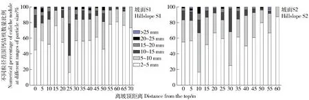
图5 不同粒径范围钙结核数量比例Fig.5 Numerical percentages of caliche nodules at different ranges of particle size
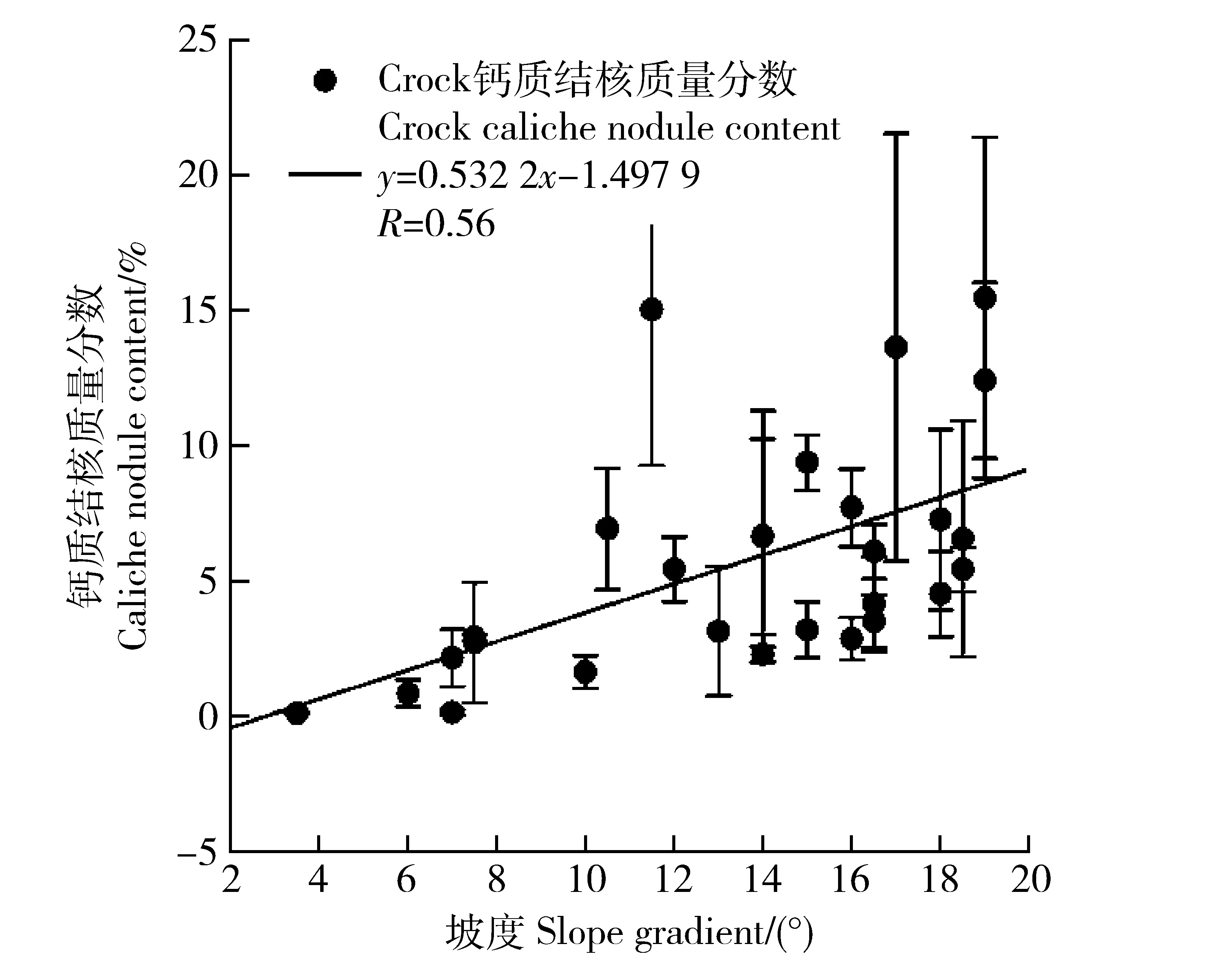
图6 钙质结核质量分数与坡度的关系Fig.6 Relationship between caliche nodule content and slope gradient
植被在消减径流动能的同时,还具有拦截作用;因此,试验对植被地上生物量和盖度进行了测定,以分析钙质结核与植被之间的关系。坡面S1和S2的建群植物均为针茅,植被盖度和地上生物量在沿坡顶向下的方向上逐渐增加。其中:植被盖度变化范围为7%~90%;植被的丰富度和多样性指数在S1坡面分别为5±2.373 8、1.301 6±0.312 8,S2坡面分别为5.269 2±2.215 5、1.39±0.584,其沿坡面没有明显的变化趋势,说明坡面植被盖度增大,主要是由于地上生物量的增加而导致的。钙质结核和植物地上生物量的关系与钙质结核质量分数沿坡面的变化一样,呈单峰曲线关系(图7)。当植被地上生物量在22 g左右,也就是盖度在11%~16%之间时,钙质结核质量分数达到最大。

图7 钙质结核质量分数与植被地上生物量的关系Fig.7 Relationship between caliche nodule content and vegetation above-ground biomass
3.4影响钙质结核分布的因素
试验计算了与钙质结核在坡面分布有关的7个因素(植被地上生物量、黏粒、粉粒、砂粒、植被盖度、丰富度和多样性指数)之间的相关关系(表1)。从相关矩阵可以看出,坡度、植被盖度、地上生物量、丰富度和多样性指数显著影响坡面钙质结核质量分数,土壤颗粒组成与钙质结核无显著相关性。也就是说,在坡面尺度上,植被(包括地上生物量、盖度和结构)和坡度是影响坡面钙质结核分布的最主要因素。其中,坡度、丰富度和多样性指数与钙质结核之间存在极显著的正相关(P<0.01,R2>0.5),植被盖度与钙质结核质量分数之间存在极显著的负相关关系(P<0.01,R2>0.5),植被地上生物量与钙质结核质量分数之间存在显著的负相关关系(P<0.05,R2>0.4)。
试验还分析了不同尺寸钙质结核影响坡面钙质结核质量分数的程度,也就是坡面上决定钙质结核质量分数的主要钙质结核尺寸范围。利用因子分析,计算坡面总的钙质结核质量分数(Crock)与6个尺寸(2~5 mm(MR1),5~10 mm(MR2),10~15 mm(MR3),15~20 mm(MR4),20~25 mm(MR5)和>25 mm(MR6))的钙质结核质量分数的相关性,并给出主成分荷载图(图8)。2个坡面上,在5~10 mm(MR2)和10~15 m(MR3)2个尺寸范围,钙质结核与坡面总的钙质结核质量分数的相关性最高(也就是MR2和MR3最靠近Crock),相关性达到极显著水平(P<0.01),决定系数R2均>0.7。这表明在坡面上,5~15 mm是坡面钙质结核的最主要组分,其多少决定了坡面钙质结核的质量分数。
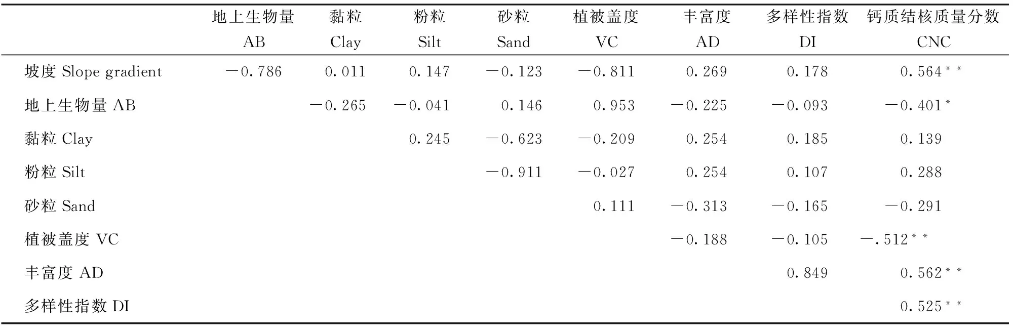
表1 钙质结核质量分数与影响因子之间的相关矩阵
注:*—显著相关(P<0.05),**—极显著相关(P<0.01)。Note:* refers to significant correlation (P<0.05) and ** refers to extremely significant correlation (P<0.01).VC:vegetation coverage; AD:abundance; DI:diversity index; CNC:caliche nodule content.
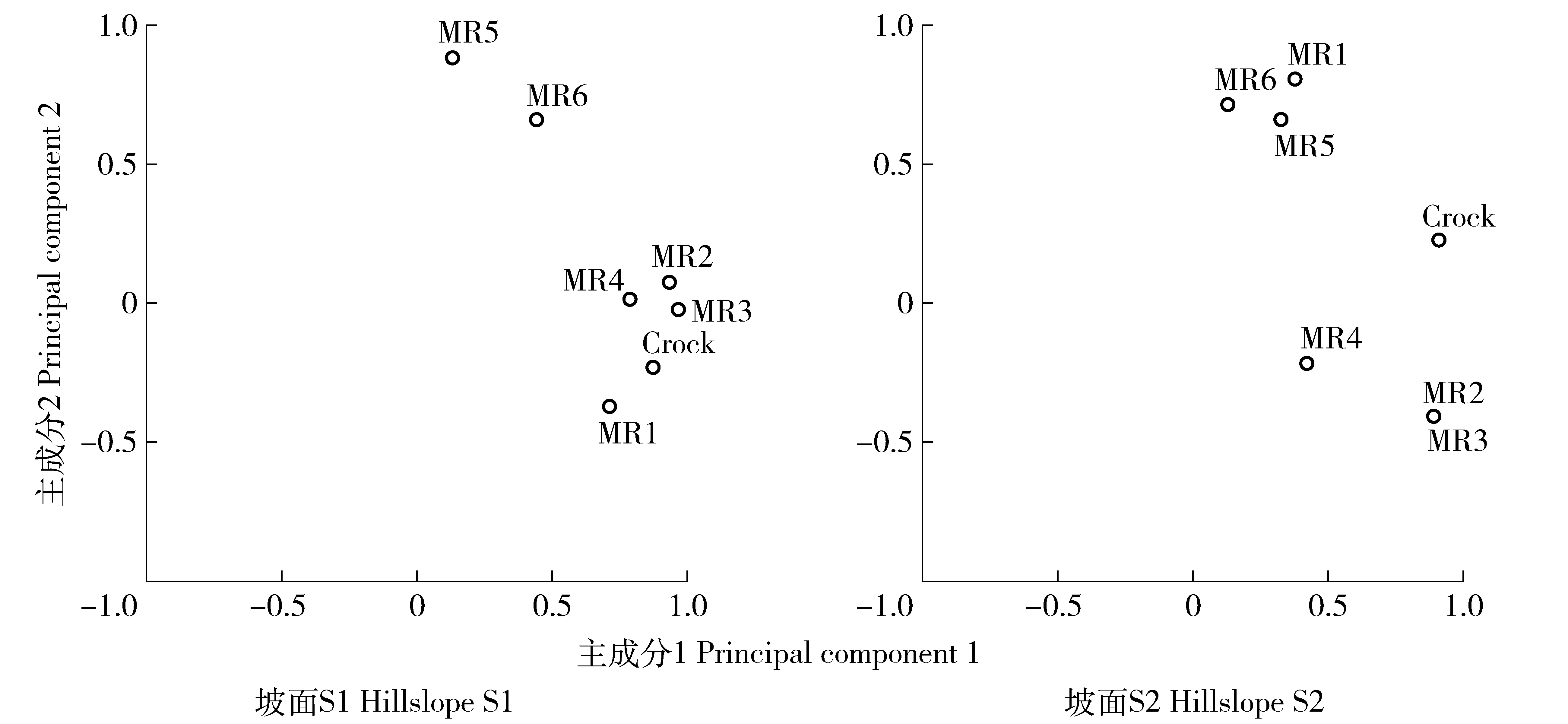
Crock represents the total caliche nodule contents on slope.MR1,MR2,MR3,MR4,MR5 and MR6 represent particle size range of caliche nodule,which are 2-5,5-10,10-15,15-20,20-25 mm respecively.图8 总钙质结核质量分数与不同粒径钙质结核质量分数的关系Fig.8 Relationship between total caliche nodule content and the caliche nodule content in different size
4 讨论
2个坡面的土壤黏粒质量分数在沿坡顶向下的方向上,均有降低的趋势(图3)。其原因在于黏粒最容易被径流带走,而且沿着坡面向下的方向,径流会越来越强,其携带能力逐渐增强,更多的黏粒会被带走,导致黏粒质量分数沿坡面逐渐降低。由于黏粒最容易受到侵蚀的影响,因此,坡面黏粒的平均质量分数可以反映坡面的侵蚀状况。坡面S1的土壤黏粒平均质量分数高于坡面S2,表明S2受到的土壤侵蚀要强于S1;而强烈的土壤侵蚀又会使得坡面变得更陡,导致坡面S2的平均坡度大于S1。侵蚀带走土壤颗粒,使得钙质结核露出地表并聚集。显然侵蚀越剧烈,表土钙质结核质量分数就会增加。
综上所述,坡面S2的侵蚀强于坡面S1,那么坡面S2的钙质结核平均质量分数也应高于S1。实际测定结果为坡面S2的钙质结核平均质量分数为6.9%,高于坡面S1的4.6%;因此,钙质结核可以指示坡面土壤侵蚀的强弱,这与砾石可以指示冰川剥蚀和沉积作用类似(Poesen 和 Lavee ,1994)。此外,钙质结核质量分数与坡度呈正相关关系,这与J.R.Simanton等[29]、Zhu Yuanjun等[27]结果一致。试验中钙质结核质量分数与植被存在单峰曲线关系(图4),表明植被对侵蚀的影响存在一个临界点(在11%~16%之间)。临界点之下,由于植被盖度小,对侵蚀的影响很小,侵蚀能够同时带走坡面的土壤颗粒和钙质结核;超过临界点,植被能通过降低径流动能和拦截作用,显著影响侵蚀,使得径流携带土壤颗粒和钙质结核的作用显著降低,其降低程度与植被地上生物量(盖度)呈正相关。
试验还发现,钙质结核尺寸越小,其在坡面的数量越多,这与J.W.Poesen等[22]、Zhu Yuanjun等[27]的研究结果一致。可见侵蚀对钙质结核的影响存在尺寸效应,也就是说小的钙质结核更容易受到影响。通过对影响坡面钙质结核的主要因素进行相关分析,进一步揭示坡度和植被是影响坡面钙质结核分布的最主要因素;同时,草地植被影响侵蚀的作用,与植被的丰富度和多样性指数呈负相关,也就是说,单一植被和大的生物量(盖度)更有效。试验还利用主成分分析,确定坡面钙质结核质量分数的钙质结核尺寸,发现坡面上5~15 mm的钙质结核是坡面钙质结核的最主要组分,决定着坡面钙质结核的质量分数。这一结果也印证了前述中对坡面不同尺寸钙质结核数量的研究结果,即尺寸小的钙质结核容易受到侵蚀的影响,在坡面的分布就越多,大尺寸的钙质结核不容易受到影响,相对就少。
5 结论
通过对黄土高原水蚀风蚀交错带六道沟小流域坡面钙质结核的分布特征,以及影响因素的分析,得出以下结论:
1)坡面土壤黏粒和钙质结核的平均质量分数,可以用于指示坡面的土壤侵蚀状况,低的黏粒质量分数和高的钙质结核质量分数指示着更为强烈的土壤侵蚀。
2)坡面钙质结核质量分数沿坡面呈单峰曲线分布,钙质结核质量分数与坡度呈线性正相关。钙质结核与植被地上生物量(盖度)呈单峰曲线关系,植被对钙质结核质量分数的影响存在一个临界点。
3)坡面小尺寸的钙质结核分布范围最广、数量最多。决定坡面钙质结核质量分数的钙质结核尺寸为5~15 mm。
[1]唐克丽,侯庆春,王斌科,等.黄土高原水蚀风蚀交错带和神木试区的环境背景及整治方向 [J].水土保持研究,1993,18(2):2.
Tang Keli,Hou Qingchun,Wang Binke,et al.The environment background and administration way of wind-water crisscross region and Shenmu experimental area on the Loess Plateau [J].Research of Soil and Water Conservation,1993,18(2):2.(in Chinese)
[2]贾恒义,雍绍萍,王富乾.神木试区的土壤资源 [J].水土保持研究,1993,18(2):36.
Jia Hengyi,Yong Shaoping,Wang Fuqian.The soil resources in the Shenmu experimental area [J].Research of Soil and Water Conservation,1993,18(2):36.(in Chinese)
[3]唐克丽,贺秀斌.黄土高原全新世黄土-古土壤演替及气候演变的再研讨 [J].第四纪研究,2004,24(2):129.
Tang Keli,He Xiubin.Re-discussion on loess-paleosol evolution and climatic change on the Loess Plateau during the Holocene [J].Quaternary Sciences,2004,24(2):129.(in Chinese)
[4]Poesen J,Lavee H.Rock fragments in top soils:significance and processes [J].Catena,1994,23(1):1.
[5]Brakensiek D L,Rawls W J.Soil containing rock fragments:effects on infiltration [J].Catena,1994,23(1):99.
[6]Ravina I,Magier J.Hydraulic conductivity and water retention of clay soils containing coarse fragments [J].Soil Science Society of America Journal,1984,48(4):736.
[7]Valentin C.Surface sealing as affected by various rock fragment covers in West Africa [J].Catena,1994,23(1):87.
[8]Poesen J,Ingelmo-Sanchez F,Mucher H.The hydrological response of soil surface to rainfall as affected by cover and position of rock fragments in the top layer[J].Earth Surface Processes and Landforms,1990,15(7):653.
[9]Poesen J,Ingelmo-Sanchez F.Runoff and sediment yield from topsoils with different porosity as affected by rock fragment cover and position [J].Catena,1992,19(5):451.
[10] Yair A,Lavee H.Runoff generative process and runoff yield from arid talus mantled slopes [J].Earth Surface Processes,1976,1(3):235.
[11] Lavee H,Poesen J W A.Overland flow generation and continuity on stone-covered soil surfaces [J].Hydrological processes,1991,5(4):345.
[12] Poesen J.Surface sealing as influenced by slope angle and position of simulated stones in the top layer of loose sediments [J].Earth Surface Processes and Landforms,1986,11(1):1.
[13] Cousin I,Nicoullaud B,Coutadeur C.Influence of rock fragments on the water retention and water percolation in a calcareous soil [J].Catena,2003,53(2):97.
[14] Danalatos N G,Kosmas C S,Moustakas N C,et al.Rock fragments IL Their impact on soil physical properties and biomass production under Mediterranean conditions [J].Soil Use and Management,1995,11(3):121.
[15] Conn J S,Snyder-Conn E K.The relationship of the rock outcrop microhabitat to germination,water relations,and phenology of Erythrina flabelliformis (Fabaceae) in southern Arizona [J].The Southwestern Naturalist,1981,25(4):443.
[16] Kemper W D,Nicks A D,Corey A T.Accumulation of water in soils under gravel and sand mulches [J].Soil Science Society of America Journal,1994,58(1):56.
[17] 朱元骏,邵明安.含砾石土壤降雨入渗过程模拟 [J].水科学进展,2010,21(6):779.
Zhu Yuanjun,Shao Ming′an.Simulation of rainfall infiltration in strony soil [J].Advances in Water Science,2010,21(6):779.(in Chinese)
[18] 朱元骏,邵明安.钙结石含量对土壤水分蒸发影响的模拟试验 [J].农业工程学报,2010,22(2):77.
Zhu Yuanjun,Shao Ming′an.Simulation experiments on soil moisture evaporation affected by caliche nodule contents [J].Agricultural Engineering Journal,2010,22(2):77.(in Chinese)
[19] Brakensiek D L,Rawls W J,Stephenson G R.Determining the saturated hydraulic conductivity of a soil containing rock fragments [J].Soil Science Society of America Journal,1986,50(3):834.
[20] Mehuys G R,Stolzy L H,Letey J,et al.Effect of stones on the hydraulic conductivity of relatively dry desert soils [J].Soil Science Society of America Journal,1975,39(1):37.
[21] Simanton J R,Renard K G,Christiansen C M,et al.Spatial distribution of surface rock fragments along catenas in semiarid Arizona and Nevada,USA [J].Catena,1994,23(1):29.
[22] Poesen J W,Wesemael B V,Bunte K,et al.Variation of rock fragment cover and size along semiarid hillslopes:a case-study from southeast Spain [J].Geomorphology,1998,23(2):323.
[23] Neave M,Rayburg S.A field investigation into the effects of progressive rainfall-induced soil seal and crust development on runoff and erosion rates:The impact of surface cover [J].Geomorphology,2007,87(4):378.
[24] Chen Hongsong,Liu Jianwei,Wang Kelin,et al.Spatial distribution of rock fragments on steep hillslopes in karst region of northwest Guangxi,China [J].Catena,2011,84(1):21.
[25] Nyssen J,Poesen J,Moeyersons J,et al.Spatial distribution of rock fragments in cultivated soils in northern Ethiopia as affected by lateral and vertical displacement processes [J].Geomorphology,2002,43(1):1.
[26] Nyssen J,Poesen J,Moeyersons J,et al.Processes and rates of rock fragment displacement on cliffs and scree slopes in an amba landscape,Ethiopia [J].Geomorphology,2006,81(3):265.
[27] Zhu Yuanjun,Shao Ming′an.Spatial distribution of surface rock fragment on hill-slopes in a small catchment in wind-water erosion crisscross region of the Loess Plateau [J].Science in China Series D:Earth Sciences,2008,51(6):862.
[28] Poesen J.Transport of rock fragments by rill flow-a field study [J].Catena Supplement,1987,8:35.
[29] Simanton J R,Toy T J.The relation between surface rock-fragment cover and semiarid hillslope profile morphology [J].Catena,1994,23(3):213.
[30] 魏兰英.马兰黄土中重矿物的研究 [J].第四纪研究,1987,7(1):49.
Wei Lanying.Study on heavy minerals in Malan loess [J].Quaternary Science,1987,7(1):49.(in Chinese)
Spatial pattern of caliche nodule in surface soil of the hillslopes in Liudaogou catchment in the wind-water erosion crisscross zone of the Loess Plateau
Gong Tiexiong1,2,Zhu Yuanjun1,2,3
(1.Institute of Soil and Water Conservation,Chinese Academy of Sciences and Ministry of Water Resources,712100,Yangling,Shaanxi,China;2.University of Chinese Academy of Science,100049,Beijing,China;3.State Key Laboratory of Soil Erosion and Dryland Farming on the Loess Plateau,Northwest A&F University,712100,Yangling,Shaanxi,China)
[Background] Loess soil is rich of calcium carbonate.With climate alternations of wetting and drying in soil genesis process,the calcium carbonate happens leaching and deposition and forms caliche in soil layer.This caliche rises to ground surface due to intensive soil erosion and human activity in the wind-water erosion crisscross region of the Loess Plateau and then it breaks down to pieces by outside forces to form caliche nodules.Quantifying the distribution pattern of caliche nodule on hillslopes can improve the understanding of soil-water process in special soil type (soil containing caliche nodules) in this region.[Methods] This study aimed to investigate the spatial pattern of caliche nodule on hillslopes,its influencing factors and their interactions through taking soil and plant samples and analyzing surface soil (0-20 cm) particle compositions,caliche nodule mass fraction,vegetation above-ground biomasses,coverage,abundances and diversity indexes in the different positions of the hillslopes.The soil samples were firstly through 2 mm sieve to separate caliche nodules from fine soil.The caliche nodules were then cleaned,dried,and weighed.Finally they were classified by sieves of 5,10,15,20 and 25 mm,respectively.Soil particle composition was measured by MS2000 laser granulometer.[Results] The results indicated that soil clay particle decreased gradually along the hillslopes.Caliche nodule content had a distribution pattern of single peak along the hillslopes and it achieved peak value (10%-15%) at the position of 1/4-1/3 hillslopes (about 20-30 m distance from the top of the hillslopes).Caliche nodule content was positively correlated with slope gradient.It had single peak curve relationship with vegetation above-ground biomass.This peak value was the threshold point of vegetation affecting caliche nodule content and the vegetation coverage at the threshold point was among 11%-16%.Slope gradient and vegetation were two most important factors to control caliche nodule distribution on the hillslopes.Small size caliche nodules spread more widely on the hillslopes and meanwhile their numbers were the most.The dominant size of caliche nodule was 5-15 mm.[Conclusions] Caliche nodule content and pattern on the hillslopes reflected the interactions between runoff,vegetation and caliche nodule.Runoff tended to take caliche nodules from higher position to lower position and its carrying force was positively related to slope gradient.Vegetation can reduce the carrying force of runoff and at the same time can intercept caliche nodule.All of these led to caliche nodule content positively related to slope gradient,and on the other hand it showed a single peak pattern along the slopes.Caliche nodule content could be used as a slope erosion indicator.
wind-water erosion crisscross zone of the Loess Plateau; caliche nodule; soil erosion; slope gradient; vegetation
2016-02-29
2016-04-14
项目名称:国家自然科学基金“黄土区水蚀风蚀交错带砾石对坡面土壤水循环的影响及机制”(41371242);中国科学院重点部署项目“黄土高原生态服务功能提升与果园水肥协同技术集成与示范”(KFZD-SW-306)
巩铁雄(1991—),男,硕士研究生。主要研究方向:土壤水分运动。E-mail:gongtiexiong@126.com
简介:朱元骏(1978—),男,博士,副研究员。主要研究方向:土壤水循环及坡面水土过程。E-mail:zhuyuanjun@foxmail.com
K903; S157.1
A
1672-3007(2016)04-0042-08
10.16843/j.sswc.2016.04.006
猜你喜欢
水土保持研究(2022年6期)2022-11-09
科海故事博览·下旬刊(2022年4期)2022-05-07
南方农业·中旬(2020年9期)2020-11-30
黑龙江工程学院学报(2020年5期)2020-10-21
小学科学(2020年9期)2020-09-26
矿产综合利用(2020年1期)2020-07-24
农业工程学报(2018年5期)2018-03-10
绿色科技(2017年15期)2017-09-01
Asian Agricultural Research(2015年10期)2015-02-06
江苏农业科学(2014年3期)2014-07-16
