
川北紫色土小流域植被建设的水土保持效应
2017-02-17 02:56郑江坤李静苑单志杰郎登潇
农业工程学报 2017年2期
郑江坤,李静苑,秦 伟,单志杰,李 柏,郎登潇,马 星,廖 峰
川北紫色土小流域植被建设的水土保持效应
郑江坤1,2,李静苑1,2,秦 伟3,4,单志杰3,4,李 柏3,4,郎登潇1,马 星1,廖 峰1
(1. 四川农业大学林学院,成都 611130;2. 四川省高校水土保持与荒漠化防治重点实验室,成都 611130;3. 中国水利水电科学研究院流域水循环模拟与调控国家重点实验室,北京 100048;4. 水利部水土保持生态工程技术研究中心,北京 100048)
定量评价林草植被的水土保持功能对合理指导紫色土区的流域综合治理具有重要作用。该研究基于鹤鸣观流域Ⅱ号支沟1985-2001年逐日径流量和输沙量,结合实测日降雨量,采用Spearman秩相关统计法分析流域径流和输沙变化趋势,应用流量历时曲线和双累积曲线分析流域植被建设实施前后径流和输沙变化特征,并定量评估植被建设的水土保持效应。结果表明:结合防护林营造时间和双累积曲线分析,把水文序列分为基准期(1985-1990年)和评价期(1991-2001年),相比基准期,评价期小流域的年均降水量减少约8.1%,而年径流深和年输沙模数却分别减少34.6%和89.9%,说明以植被建设为主的人类活动起到重要作用。同时,植被建设的削洪增枯效果明显,评价期的丰水日径流深和平水日径流深较基准期分别减少了84.2%和76.3%,而枯水日径流深却增加了650.0%;结合双累积曲线和分离判别法可知,植被建设在径流和输沙变化中的贡献率分别达92.9%和94.3%,大规模的植被建设在减少土壤侵蚀的同时也减少了产流量,考虑到水安全问题,未来植被建设应合理规划。
植被;径流;泥沙;紫色土;保水固土;流量历时曲线;双累积曲线
0 引 言
降雨径流的形成过程是降雨经植物截留、填洼和下渗等损失后,在重力作用下沿坡面流动的浅层明流,结合地下径流汇聚到河槽,形成出口断面的流量过程[1]。坡面薄层水流是坡面径流的初始阶段和坡面侵蚀演变的初始动力,继而可发展为浅沟侵蚀和沟道侵蚀[2]。一些学者探讨了模拟降雨或放水冲刷试验下不同土壤质地的坡面产流产沙状况。李学增等[3]通过室内模拟冲刷试验,得出不同冲刷槽宽度下的累计径流量差异不显著,而累计产沙量和平均含沙量差异显著;史东梅等[4]通过野外放水冲刷法研究了不同土石比工程堆积体径流侵蚀规律,提出偏土质坡体的产流产沙量大于偏石质坡体;李建明等[5]利用室内模拟降雨方法研究了3种土壤质地工程堆积体径流产沙规律,发现砂土堆积体的径流侵蚀量均为最大;魏霞等[6]通过室内交替冻融试验和模拟降雨试验,得出交替冻融作用对产流产沙的影响小,而土壤质量含水率的影响较大;唐辉等[7]提出降雨后,地表粗糙度的增幅最小,而洼地蓄积量的增幅最大,地形因子与产流率和累计产沙量之间呈线性相关。同时,耕作措施和土地利用格局也会影响坡面的径流输沙。谢颂华等[8]研究了南方红壤区不同耕作措施的减流减沙规律,提出横坡间作优于顺坡间作,且套种作物能够有效防止水土流失;陈洪松等[9]通过13个大型径流小区5 a的定位观测,得出喀斯特峰丛洼地以微度土壤侵蚀为主,土地利用方式对侵蚀产沙影响较小;佘冬立等[10]发现土地利用镶嵌格局是控制水土流失的重要措施,相对于单一利用的坡耕地小区,混合利用格局可有效拦截坡面径流侵蚀。相比于坡面尺度,流域尺度由于影响因素多,干扰作用大,这就增加了相关研究的复杂性和不确定性;流域径流和侵蚀产沙是气候条件与下垫面综合作用的复杂产物,降水变化影响流域水沙输移过程,人类活动通过改变土地利用方式和实施水土保持措施来改变流域下垫面,使产流产沙机制发生变化[11-12]。以工程措施为主治理水土流失在措施生效期间能有效减少水沙,但无法改善流域内部侵蚀状况,解决水土流失问题的根本途径在于恢复植被[13]。赵跃中等[14]提出以植被恢复为主导的水土保持措施减沙作用极强;郭军庭等[15]研究表明潮河流域产流产沙随植被覆盖增加呈大幅减少趋势;蔺鹏飞等[16]通过对北洛河流域的研究,提出退耕还林(草)生态工程能发挥良好的蓄水保土、减少泥沙等生态效益;Hueso-González等[17]也认为恢复植被是控制地中海流域水土流失的最佳途径。紫色土区作为土壤侵蚀最为严重的地区之一,以往研究多集中在整地措施[18]、植物篱措施[19],土壤水分空间异质性[20]、土壤厚度[21]等坡面尺度上,基于流域尺度的水文过程研究较少。
本文以川北深丘型紫色土小流域为研究对象,基于流域水文站实测资料,采用水文统计法和趋势分析法,确定1985-2001年时段内径流、输沙变化趋势和评价时段,定量评估植被建设活动对流域内产流产沙变化的影响,以期为该区生态恢复和水土流失防治提供科学依据。
1 研究区概况
鹤鸣观小流域位于四川省南充市南部县(105°44′E、31°31′N),属嘉陵江一级支流西河流域,由3条支沟组成,流域面积1.7 km2。基岩为白垩纪砂岩及砂质黏土岩,土壤以石灰性紫色土为主,该流域坡耕地比重大,土层薄,复种指数高,抗蚀性差。另外,该区雨量丰富,降雨相对集中,水土流失严重。20世纪80年代末该区实施长江上游防护林体系建设工程,水土流失得到有效遏制,河道径流和输沙发生了明显改变[22]。本研究选择Ⅱ号支沟流域为研究对象,流域面积为42 hm2,呈羽状,沟道平均比降为31%(表1)。流域属亚热带季风气候,年平均降雨量5-10月最为集中,约占总降雨量的74%。土壤侵蚀以中强度侵蚀为主,自然植被类型较简单,原始森林极少,多为天然次生林和人工林,流域内主要树种为桤木(Burk.)、马尾松(Lamb.)、柏木(Endl.)、麻栎(Carruth.)等,以桤柏混交及柏木次生林为主。该流域治理工作以林草措施为主,1987年进行前期水土保持治理,1991年在前期治理基础上,对原有工程清淤整治,新开沿山沟、排洪沟等;治理期间,共栽植桤木5.33万株,柏木3.74万株,桑树()3.14万株,柑橘(Blanco)800株,种植马桑(Wall.)、黄荆(Linn.)约10.33 hm2;依据植被建设实施时间把研究时段划分为基准期(1985-1990年)与评价期(1991-2001年)。评价期土地利用结构和林草覆盖率发生了显著改变,具体数据见表2。

表1 鹤鸣观Ⅱ号支沟流域特征值
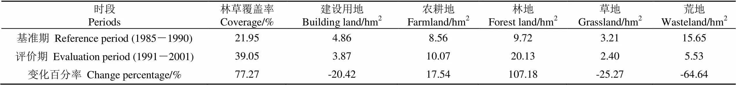
表2 鹤鸣观Ⅱ号支沟小流域土地利用结构变化
2 数据与方法
2.1 数据来源
本研究选择升钟水土保持试验站1985-2001年逐日降水观测资料、卡口站逐日径流量和输沙量,资料摘自《四川省水土保持试验站观测成果资料汇编》。采用逐日数据累计到月、年等时段内,进行相应的统计分析。由于流域面积小,干流长度仅0.35 km,河网密度也较小(表1),枯期(11月至次年4月)基本上无产流产沙数据,故本文采用汛期(5-10月)数据进行相应分析。鹤鸣观Ⅱ号支沟小流域地处深山区,林地和荒地治理后较治理前变化较大,变化百分率分别达到107.18%和−64.64%,而农耕地和建设用地变化较小,变化率均低于21%(表2);且该小流域没有库坝工程建设,故将植被建设作为人类活动的表现形式,进而研究其对流域产流产沙的影响。
2.2 研究方法
2.2.1 要素的变化趋势分析
根据流域年径流深及年输沙量变化,结合植被建设实施时间把研究时段划分为基准期(1985-1990年)与评价期(1991-2001年)。径流趋势分析采用Spearman秩相关检验非参数统计法,对数据序列的时间趋势性进行检测,公式如下[23]
式中为Spearman秩相关系数;d为变量X和Y的差值,X为原时间顺序排列序号,Y为变量(输沙量和径流量)从小到大排列的序号;为元素个数。
2.2.2 流量历时曲线
分析流域某一给定流量与发生频次关系的流量历时曲线,表示某一流量超过某一流量记录的时间比例,综合描述流域径流从枯水到丰水整个阶段的特征,可较好反映流域降雨径流特性[16],故常应用于土地利用引起的区域水文特征变化和环境效应研究中。按研究期的日流量从大到小排序,排序轴上发生频率所占比重为5%、50%和95%时所对应的流量分别代表丰水流量、平水流量和枯水流量。在趋势分析基础上采用日径流数据构建曲线,分析植被建设前后时期丰水、平水和枯水等不同频率下径流情势,通过计算植被建设前后相同频率下的径流深之差与实施前同一频率下径流深的百分比,即为实施前后不同频率径流的相对变化比例。
2.2.3 双累积曲线法
双累积曲线法是目前分析水文要素一致性或长期变化趋势最简单直观的方法。绘制年降水量-年径流输沙曲线,若流域下垫面特性保持不变,径流主要受降水影响(极端降水事件除外),2变量各自累积值在直角坐标系表示为一条直线;若曲线发生偏转,则流域下垫面发生变化,可确定斜率转折点为降水-径流、输沙关系受植被建设影响发生变化的时间,以此进行时段划分,确定基准期时段,将基准期实测值变量间建立的关系式带入评价期,得到仅降水量变化而不考虑下垫面变化情况下评价期模拟的径流累积值[24]。
2.2.4 分离判别法
采用流域水文模拟途径分析植被建设对流域径流和输沙的影响,依据实测水文过程变化特性和植被建设状况划分基准期与效应期。利用基准期的降雨及径流输沙资料确定水文模型,保持模型参数不变,将植被建设影响期间的降雨及径流输沙资料输入模型还原出模拟径流量和输沙量,反映出无植被建设影响下的产流产沙过程[25]。
式中ΔW为径流输沙在植被建设前后变化量;ΔW为植被建设对径流、输沙的影响量,即效应期实测值与模拟值间的减少量;ΔW为降水因子对径流、输沙的影响量;W为基准期的实测径流、输沙量;W为植被建设影响时期的实测径流、输沙量;W为植被建设影响时期的模拟径流、输沙量;文中径流量和输沙量的单位分别为mm和t。由水文模型计算得出,η和η分别为植被建设和降水因子对径流输沙影响的百分比,%。
3 结果与分析
3.1 径流输沙演变趋势分析
鹤鸣观小流域水土流失严重,河流泥沙含量高,长江防护林工程不断推进后,径流输沙量明显减少。由图1和表3可知,1990年后输沙模数呈明显下降趋势,年降雨量较植被建设前减少约8.1%,年径流深及输沙模数却分别减少34.6%及89.9%,输沙模数和径流深均随降雨量呈同步变化,降雨量在1997年后出现小幅增加,同时输沙模数也有一定程度的增加。年径流量及输沙模数的Spearman秩相关系数为负值,其中输沙模数秩相关系数在0.01水平上呈显著性变化,降雨量和径流量的变化未达到任何显著性水平。随着时间的推移,输沙量有显著减小趋势,但径流量下降趋势微弱,说明植被建设能够显著减少土壤侵蚀,但对年径流的作用不明显。
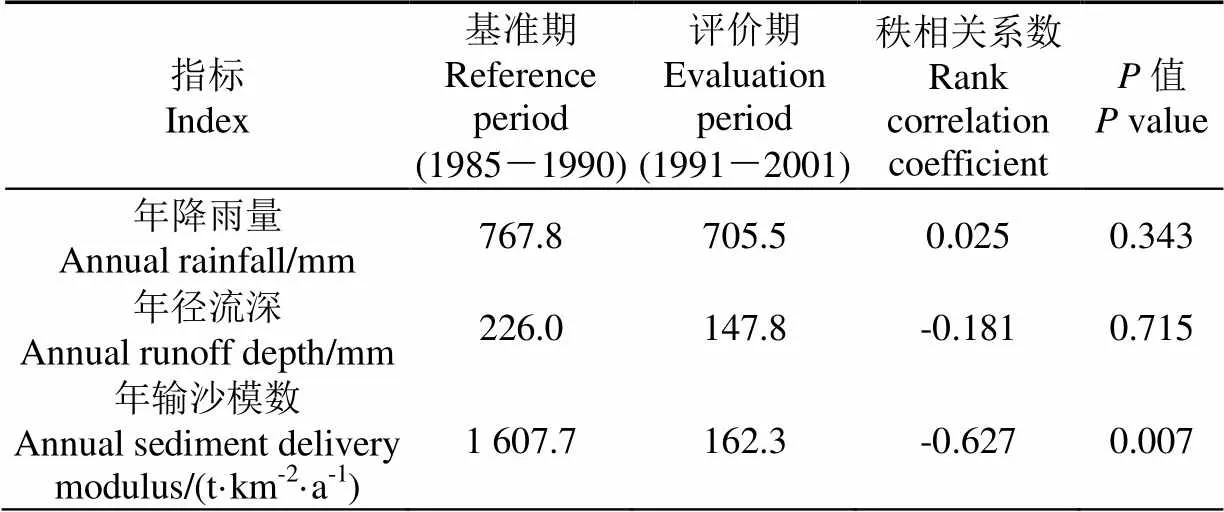
表3 鹤鸣观Ⅱ号支沟小流域水文要素年际变化的Spearman秩相关分析
3.2 植被建设的水文效应
与基准期相比,评价期的日径流深在发生频率为80%之前较小且差值趋于缩小,而在频率为80%之后较大且差值趋于增大(图2)。丰水期日径流深和平水期日径流深分别减少了84.2%和76.3%,而枯水期日径流深则大幅增加,较基准期增加了650.0%,说明植被建设在减少年径流总量时,也在一定程度上削弱和调控了丰水和平水流量(表4),同时导致枯水径流剧烈变化[2]。
根据以上分析结果,植被建设后,流域流量历时曲线趋于平缓,日径流量变化较前期趋于均匀,枯水径流增加明显,丰水和平水流量变化较平缓,径流量有所减少。植被建设增强了流域下垫面的降水入渗能力,增加了径流的下渗量和截留量,延缓径流发生,影响流域产汇流机制,因而丰水和平水流量有所减缓。根据降雨的分析,鹤鸣观Ⅱ号流域降水呈减少趋势。降水是流域径流的主要来源,鹤鸣观流域以超渗产流为主,而林冠层在极端降雨等事件中,最大储蓄水量达到饱和后反而有利于产流,且水土保持措施的实施有利于流域涵养水源补给枯季流量,故在植被建设后枯水流量反而有所增加[26]。

表4 鹤鸣观Ⅱ号支沟小流域不同发生频率日径流深及其变化率
注:表中丰水日径流深代表发生频率为5%时的日径流深,丰水变化率表示评价期较基准期发生频率为5%的变化比率,以此类推。
Note: Runoff depth under high flow refers to daily runoff depth at frequency of 5%. Change percentage of high flow refers to change ratio between evaluation period and reference period at frequency of 5%, and so on.
3.3 植被建设的减流减沙作用
由图3可知,累积降雨量与累积径流深、累积输沙量均呈正相关。极端降水事件虽增加了曲线波动,但年径流深与年降雨量关系基本成一直线,总体呈线性增加,植被措施对径流影响较小。由年降雨量-年输沙量关系可知1989年后斜率明显偏小,前期简单的治理措施有所成效。1991年后曲线向下偏转基本呈水平,1995—1997年曲线斜率趋于水平,成为水沙的平稳下降段,1997年以后年降水量恢复性增加,使得双累积曲线继续向下偏转的幅度得到了遏制,说明输沙量明显减少,植被建设对减沙效果显著,也进一步验证1991年为植被建设生效的转折年。
20世纪80年代前由于自然条件及人类活动破坏,水土流失十分严重,1987年进行前期水土保持治理,1991年实施以林草措施为主的治理措施,水土流失得到进一步治理,是该时期流域水沙减少的重要原因。水沙关系在90年代初发生转变,沿程减弱。随着流域综合治理的不断开展,依据双累积曲线法计算得出,至2001年植被建设已累计减少径流798.9 mm,减少输沙5 096.8 t(图3)。降水对流域减水减沙的影响力在逐步减弱。植被建设是影响流域输沙减少的主要驱动力,也逐渐成为影响流域输沙变化的主要因素,对基准期年降水量与径流量和输沙量累积值分别进行拟合,得到拟合曲线及方程并进行计算,由分离判别法可知,植被建设在减水减沙方面的贡献率分别为92.9%和94.3%(表5)。由于植被能够通过林冠层和地被层降低降雨的击溅作用,消弱雨滴对地表的溅蚀动能,同时,通过增加土壤中的根系含量,增加土壤入渗,从而减少地表径流。植被建设可以增加土壤中有机质含量,改善土壤团聚体结构,从而提高土壤的抗冲抗蚀能力,减少输沙量。由于小流域尺度上的径流由地表径流和地下径流组成,故植被建设在年尺度上对径流的影响较小,但对径流的年内分配的作用较大。土壤侵蚀主要发生在土壤表层,植被通过根系固土、改善土壤结构、增加入渗等方式显著地减少了输沙的输移量,故而减沙效果优于减流。
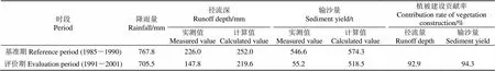
表5 植被建设对鹤鸣观Ⅱ号支沟小流域径流深、输沙量变化的贡献
4 讨 论
4.1 植被建设调节沟道径流作用
评价期期间没有增加工程措施,和基准期相比,荒地大量减少,林地约增加了1倍,说明很多荒地转变为林地,而林地对流域径流变化的敏感性最强[27]。通过图1可知,流域评价期年径流量较基准期有一定的减少,说明随着森林植被覆盖度增加,枯落物层也随之加厚,地表粗糙度增加,滞缓了地表径流速度,再加上森林植被发达的根系结构,有助于优先流的生成,从而增加了土壤入渗,多数降水先与土壤相互作用,而后转变为地下水或蒸发[28],随着树木生长,更多降水被截留蒸发,年降水变化不明显的情况下蒸散发增加又必定导致径流减少。但由于小流域尺度上的径流由地表径流和亚地表径流组成,降水通过不同介质传输后大部分仍会汇集到沟道中,故植被建设在年尺度上对径流的影响较小。年降水量与年径流量的线性相关性较好,说明降水是引起紫色土区沟道径流变化的主要因素。但植被建设对径流的年内分配的作用得到了凸显,有较明显的消洪补枯作用。在植被覆盖度较高的流域,汛期部分降水可先被地被物及其土壤层截留储存起来,补充到地下,而壤中流和地下径流流动速度很慢,从而可以减弱洪峰流量,保留在地面以下的水分通过泉水或侧向渗透等方式在枯水时期会对沟道径流进行一定的补充,从而达到调节径流年内分配的作用。
4.2 植被建设控制土壤侵蚀作用
简单的流域前期治理使得林草面积迅速增加,但占总面积比例较小,部分工程措施在1990年后已失去作用,由于植被建设等人类活动极大扰动了下垫面,下垫面变得疏松,抗蚀性减弱,使得流域侵蚀产沙量在1991年有所增加,而后随着植被生态功能的稳定发挥,土壤侵蚀量显著减少,在年尺度上减沙效果优于减流。这一方面由于植被能够通过林冠层和地被层降低降雨的击溅作用,削弱雨滴对地表的溅蚀动能,从而可减少击溅侵蚀量;另一方面,植被建设可以增加土壤中有机质含量,改善土壤团聚体结构,从而提高土壤的抗冲抗蚀能力,减少输沙量[14]。此外,土壤侵蚀主要发生在土壤表层,植被通过根系固土、改善土壤结构、增加入渗等方式也会显著减少泥沙的输移量[16,26]。许炯心[29]在多沙粗沙区的研究中也有类似分析。同时,径流对流域输沙有重要影响,流量小于某一临界值时,单位径流输沙量与其呈正相关;流量超过临界值,单位径流输沙量才与泥沙补给量有关[30];伴随下垫面输沙条件改变,降水产流和侵蚀产沙能力降低,沟道流量锐减导致年输沙量也显著减少。综上可知,森林植被对流域土壤侵蚀的控制作用更为明显,这种主导作用与国内外学者相关研究结论较为一致[31-32]。
5 结 论
1)鹤鸣观Ⅱ号支沟小流域作为川北深丘型紫色土小流域,1985-2001年间年降雨和年径流深没有显著性变化,输沙量却显著减少。和基准期相比,评价期输沙模数减少了89.9%,说明以植被建设为主的人类活动对流域产沙的作用更加明显。
2)评价期流量历时曲线较基准期平缓,日径流深年内分配趋于均匀,说明植被建设在评价期表现的削洪增枯效果明显。其中评价期丰水日径流深和平水日径流深分别较基准期减少了84.2%和76.3%,而枯水日径流深却呈明显增加趋势,较基准期增加了650.0%。
3)大规模的植被建设对该小流域的固土保水作用明显,控制水土流失的贡献率达到90%以上,且固土作用强于保水。考虑到上下游用水安全需求,以后进行植被建设时,不但要控制土壤侵蚀,而且要保证水资源的供给,从而制定合理有效的水土保持措施。
[1] 杨大文,杨汉波,雷慧闽. 流域水文学[M]. 北京:清华大学出版社,2014.
[2] 张宽地,王光谦,孙晓敏,等. 坡面薄层水流水动力学特性试验[J]. 农业工程学报,2014,30(15):182-189.
Zhang Kuandi, Wang Guangqian, Sun Xiaomin, et al. Experiment on hydraulic characteristics of shallow open channel flow on slope[J]. Transactions of the Chinese Society of Agricultural Engineering (Transactions of the CSAE), 2014, 30(15): 182-189. (in Chinese with English abstract)
[3] 李学增,黄炎和,林金石,等. 不同宽度冲刷槽对崩岗崩积体产流产沙的影响[J]. 农业工程学报,2016,32(9):136-141.
Li Xuezeng, Huang Yanhe, Lin Jinshi, et al. Effects of different width of scouring flumes on runoff and sediment yield of colluvial deposits of collapsing hill[J]. Transactions of the Chinese Society of Agricultural Engineering (Transactions of the CSAE), 2016, 32(9): 136-141. (in Chinese with English abstract)
[4] 史东梅,蒋光毅,彭旭东,等. 不同土石比的工程堆积体边坡径流侵蚀过程[J]. 农业工程学报,2015,31(17):152-161.
Shi Dongmei, Jiang Guangyi, Peng Xudong, et al. Runoff erosion process on slope of engineering accumulation with different soil-rock ratio[J]. Transactions of the Chinese Society of Agricultural Engineering (Transactions of the CSAE), 2015, 31(17): 152-161. (in Chinese with English abstract)
[5] 李建明,牛俊,王文龙,等. 不同土质工程堆积体径流产沙差异[J]. 农业工程学报,2016,32(14):187-194.
Li Jianming, Niu Jun, Wang Wenlong, et al. Differences in characteristics of runoff and sediment yielding from engineering accumulations with different soil textures[J]. Transactions of the Chinese Society of Agricultural Engineering (Transactions of the CSAE), 2016, 32(14): 187-194. (in Chinese with English abstract)
[6] 魏霞,李勋贵,Huang Chihua. 交替冻融对坡面产流产沙的影响[J]. 农业工程学报,2015,31(13):157-163.
Wei Xia, Li Xungui, Huang Chihua. Impacts of freeze-thaw cycles on runoff and sediment yield of slope land[J]. Transactions of the Chinese Society of Agricultural Engineering (Transactions of the CSAE), 2015, 31(13): 157-163. (in Chinese with English abstract)
[7] 唐辉,李占斌,李鹏,等. 模拟降雨下坡面微地形量化及其与产流产沙的关系[J]. 农业工程学报,2015,31(24):127-133.
Tang Hui, Li Zhanbin, Li Peng, et al. Surface micro topography quantification and its relationship with runoff and sediment under simulated rainfall[J]. Transactions of the Chinese Society of Agricultural Engineering (Transactions of the CSAE), 2015, 31(24): 127-133. (in Chinese with English abstract)
[8] 谢颂华,曾建玲,杨洁,等. 南方红壤坡地不同耕作措施的水土保持效应[J]. 农业工程学报,2010,26(9):81-86.
Xie Songhua, Zeng Jianling, Yang Jie, et al. Effects of different tillage measures on soil and water conservation in slope farmland of red soil in Southern China[J]. Transactions of the Chinese Society of Agricultural Engineering (Transactions of the CSAE), 2010, 26(9): 81-86. (in Chinese with English abstract)
[9] 陈洪松,杨静,傅伟,等. 桂西北喀斯特峰丛不同土地利用方式坡面产流产沙特征[J]. 农业工程学报,2012,28(16):121-126.
Chen Hongsong, Yang Jing, Fu Wei, et al. Characteristics of slope runoff and sediment yield on karst hill-slope with different land-use types in northwest Guangxi[J]. Transactions of the Chinese Society of Agricultural Engineering (Transactions of the CSAE), 2012, 28(16): 121-126. (in Chinese with English abstract)
[10] 佘冬立,邵明安,薛亚锋,等. 坡面土地利用格局变化的水土保持效应[J]. 农业工程学报,2011,27(4):22-27.
She Dongli, Shao Ming’an, Xue Yafeng, et al. Soil-water conservation effects of slope land use pattern changes[J]. Transactions of the Chinese Society of Agricultural Engineering (Transactions of the CSAE), 2011, 27(4): 22-27. (in Chinese with English abstract)
[11] Zheng Jiangkun, Sun Ge, Li Wenhong, et al. Impacts of land use change and climate variations on annual inflow into the Miyun Reservoir, Beijing, China[J]. Hydrol Earth Syst Sci, 2016, 20: 1561-1572.
[12] 晏清洪,原翠萍,雷廷武,等. 降水和水土保持对黄土区流域水沙关系的影响[J]. 中国水土保持科学,2013,11(4):9-16.
Yan Qinghong, Yuan Cuiping, Lei Tingwu, et al. Effects of precipitation and erosion control practices on the rainfall-runoff-sediment delivery relationships of typical watersheds in the hilly-gully region on the Loess Plateau[J]. Science of Soil and Water Conservation, 2013, 11(4): 9-16. (in Chinese with English abstract)
[13] 刘刚才,游翔,张建辉,等. 紫色土丘陵区小流域综合治理对水土保持的作用[J]. 山地学报,2007,25(5):590-595.
Liu Gangcai, You Xiang, Zhang Jianhui, et al. The effects of integrated counter measures on soil and water conservation of the small watershed in hilly area of Sichuan basin[J]. Journal of Mountain Science, 2007, 25(5): 590-595. (in Chinese with English abstract)
[14] 赵跃中,穆兴民,严宝文,等. 延河流域植被恢复对径流泥沙的影响[J]. 泥沙研究,2014(4):67-73.
Zhao Yuezhong, Mu Xingmin, Yan Baowen, et al. Influence of vegetation restoration on runoff and sediment of Yanhe basin[J]. Journal of Sediment Research, 2014(4): 67-73. (in Chinese with English abstract)
[15] 郭军庭,张志强,王盛萍,等. 气候和土地利用变化对潮河流域产流产沙的影响[J]. 农业工程学报,2012,28(14):236-243.
Guo Junting, Zhang Zhiqiang, Wang Shengping, et al. Effects of climate and land use changes on stream flow and sediment yield in Chaohe river basin[J]. Transactions of the Chinese Society of Agricultural Engineering (Transactions of the CSAE), 2012, 28(14): 236-243. (in Chinese with English abstract)
[16] 蔺鹏飞,张晓萍,刘二佳,等. 黄土高原典型流域水沙关系对退耕还林(草)的响应[J]. 水土保持学报,2015,29(1):1-6.
Lin Pengfei, Zhang Xiaoping, Liu Erjia, et al. Responses of the water and sediment behavior to vegetation restoration in typical catchments on the Loess plateau[J]. Journal of Soil and Water Conservation, 2015, 29(1): 1-6. (in Chinese with English abstract)
[17] Hueso-González P, Ruiz-Sinoga J D, Martínez-Murillo J F, et al. Overland flow generation mechanisms affected by topsoil treatment: Application to soil conservation[J]. Geomorphology, 2015, 228: 796-804.
[18] 李静苑,蒲晓君,郑江坤,等. 整地与植被调整对紫色土区坡面产流产沙的影响[J]. 水土保持学报,2015,29(3):81-85.
Li Jingyuan, Pu Xiaojun, Zheng Jiangkun, et al. Effects of soil preparation and vegetation adjustment on slope runoff and sediment yield in purple soil region, Northeastern Sichuan[J]. Journal of Soil and Water Conservation, 2015, 29(3): 81-85 (in Chinese with English abstract)
[19] 谌芸,何丙辉,向明辉,等. 紫色土坡耕地植物篱的水土保持效应研究[J]. 水土保持学报,2013,27(2):47-52.
Chen Yun, He Binghui, Xiang Minghui, et al. Effects of hedgerow on soil and water conservation in sloping cropland of the purple soil[J]. Journal of Soil and Water Conservation, 2013, 27(2): 47-52. (in Chinese with English abstract)
[20] 史志华,朱华德,陈佳,等. 小流域土壤水分空间异质性及其与环境因子的关系[J]. 应用生态学报,2012,23(4):889-895.
Shi Zhihua, Zhu Huade, Chen Jia, et al. Spatial heterogeneity of soil moisture and its relationships with environmental factors at small catchment level[J]. Chin J Appl Ecol, 2012, 23(4): 889-895. (in Chinese with English abstract)
[21] 陈佳,史志华,李璐,等. 小流域土层厚度对土壤水分时空格局的影响[J]. 应用生态学报,2009,20(7):1565-1570.
Chen Jia, Shi Zhihua, Li Lu, et al. Effects of soil thickness on spatiotemporal pattern of soil moisture in catchment level[J]. Chin J Appl Ecol, 2009, 20(7): 1565-1570. (in Chinese with English abstract)
[22] 袁再健,蔡强国,吴淑安,等. 四川紫色土地区典型小流域分布式产汇流模型研究[J]. 农业工程学报,2006,22(4):36-41.
Yuan Zaijian, Cai Qiangguo, Wu Shu’an, et al. Distributed model for simulating runoff yield in the typical watershed of the purple soil region in Sichuan Province[J]. Transactions of the Chinese Society of Agricultural Engineering (Transactions of the CSAE), 2006, 22(4): 36-41. (in Chinese with English abstract)
[23] 涂安国,杨洁,李英,等. 人类活动对赣江入湖泥沙量的影响[J]. 水土保持学报,2013,27(2):76-79.
Tu Anguo, Yang jie, Li ying, et al. Effect of human activities on sediment load evolution into Poyang lake from Ganjiang river[J]. Journal of Soil and Water Conservation. 2013, 27(2): 76-79. (in Chinese with English abstract)
[24] 胡彩虹,管新建,吴泽宁,等. 水土保持措施和气候变化对汾河水库入库径流贡献定量分析[J]. 水土保持学报,2011,25(5):12-16.
Hu Caihong, Guan Xinjian, Wu Zening, et al. Analysis for contribution of soil and water conservation and climate change to runoff in the upper researches of Fenhe reservation[J]. Journal of Soil and Water Conservation, 2011, 25(5): 12-16. (in Chinese with English abstract)
[25] 张建云,王国庆. 气候变化对水文水资源影响研究[M]. 北京:科学出版社,2007.
[26] 张亭亭,张建军,郭敏杰,等. 北洛河流域不同地貌和植被类型区径流演变特征及控制因素[J]. 水土保持学报,2014,28(4):78-84.
Zhang Tingting, Zhang Jianjun, Guo Minjie, et al. Trend of streamflow and its controlling factor under the regional vegetation restoration in Beiluo river basin[J]. Journal of Soil and Water Conservation. 2014, 28(4): 78-84. (in Chinese with English abstract)
[27] Zheng Jiangkun, Yu Xinxiao, Deng Wenping, et al. Sensitivity of land use change to streamflow in Chaobai River Basin[J]. J Hydrol Eng, 2013, 18(4): 457-464.
[28] 张淑兰,王彦辉,于澎涛,等. 定量区分人类活动和降水量变化对泾河上游径流变化的影响[J]. 水土保持学报,
2010,24(4):53-58.
Zhang Shulan, Wang Yanhui, Yu Pengtao, et al. Study for separating the impact of precipitation variation and human activities on runoff change of the upper reaches of Jing river[J]. Journal of Soil and Water Conservation. 2010, 24(4): 53-58. (in Chinese with English abstract)
[29] 许炯心. 黄河中游多沙粗沙区1997-2007年的水沙变化趋势及其成因[J]. 水土保持学报,2010,24(1):1-7.
Xu Jiongxin. Trend of sediment yield in the coarser sediment-producing area in the middle yellow river basin in the period 1997-2007 and the formative cause[J]. Journal of Soil and Water Conservation, 2010, 24(1): 1-7. (in Chinese with English abstract)
[30] 郑明国,蔡强国,程琴娟. 一种新的流域水沙关系模型及其在年际时间尺度的应用[J]. 地理研究,2007,26(4):745-754.
Zheng Mingguo, Cai Qiangguo, Cheng Qinjuan. One new sediment yield model for single storm events and its application at annual time scale[J]. Geographical Research, 2007, 26(4): 745-754. (in Chinese with English abstract)
[31] Xu Qingxue, Wang Tianwei, Cai Chongfa, et al. Responses of runoff and soil erosion to vegetation removal and tillage on steep lands[J]. Pedosphere, 2013, 23(4): 532-541.
[32] Zuazo V H D, Pleguezuelo C R R. Soil-erosion and runoff prevention by plant covers. A review[J]. Agronomy for Sustainable Development, 2008, 28(1): 65-86.
Effects of vegetation construction on soil and water conservation in small watershed of purplish soil region, northern Sichuan
Zheng Jiangkun1,2, Li Jingyuan1,2, Qin Wei3,4, Shan Zhijie3,4, Li Bai3,4, Lang Dengxiao1, Ma Xing1, Liao Feng1
(1.,,611130,;2.,611130,;3.,,100048,;4,100048,)
Purple soil is thin in depth and its corrosion resistance is poor. Coupled with heavy and concentrated rainfall and severe human disturbance, soil erosion is very serious. In recent decades, especially later 1980s, projects of forestry ecological engineering have been implemented in the area, which has brought remarkable ecological benefit. It is important for watershed manager to quantitatively evaluate soil and water conservation function of vegetation construction. Based on daily rainfall, daily runoff and daily sediment yield during 1985-2001 in Hemingguan watershed II of northern Sichuan, the change trends of runoff and sediment were analyzed by Spearman’s correlation analysis. Moreover, the effect of soil and water conservation of vegetation construction was evaluated quantitatively using the methods of double mass curve and flow duration curve. The results showed that the reference period (1985-1990) and the evaluation period (1991-2001) were separated from the hydrological sequences according to the result of double mass curve and the implement time of vegetation construction. Compared with the reference period, annual runoff depth and annual sediment delivery modulus reduced by 34.6% and 89.9% in the evaluation period, whereas annual rainfall only reduced by 8.1%. It was illustrated that vegetation construction, as the main part of human activity, played an important role for runoff and sediment reduction. With forest vegetation restoring, more and more rainfall was intercepted by canopy and litter of forest. Then the intercepted water was translated into vapor by evapotranspiration of forestland or groundwater through infiltration. If annual rainfall remained unchanged, surface runoff turned smaller as evapotranspiration grew up. Simultaneously, with forest vegetation construction, forest vegetation reduced soil erosion with the improvement of root fixation, soil structure and infiltration rate. Terrain roughness was another cause to reduce soil erosion accompanied by surface runoff. The forest vegetation might control surface runoff by lush foliage and huge root system. High flow and normal flow during the evaluation period reduced by 84.2% and 76.3% compared to those during the reference period. Nevertheless, low flow increased by 650.0%. Vegetation construction obviously reduced high flow and increased low flow. The rainfall infiltration capacity of watershed underlying surface was enhanced by the vegetation construction, which increased the rainfall infiltration content and runoff interception, and delayed the formation of runoff. Therefore, high flow turned to smaller during the period of vegetation construction. In drought period, the water stored in soil and groundwater began to be released to feed low flow. For forest watershed, a large amount of water was restored under the surface, which might provide more water than bare watershed. So, in the period of vegetation construction, low flow showed an increasing trend instead of decreasing. Combining double mass curve with separation and discrimination method, the vegetation construction’s contribution to the reduction of runoff and sediment was 92.9% and 94.3% during the evaluation period, respectively. In the watershed of 42 hm2, from 1987 to 1991, a total of 53 thousandBurk., 37 thousandEndl., 31 thousandL., 800Blanco, 10 hm2Wall.andLinn were planted. Forestland was increased from 9.72 to 20.13 hm2, which made coverage increased by over 1 time. It was seen that vegetation construction has exerted a leading role on the decrement of runoff and sediment. Furthermore, the effect of soil conservation is better than that of water conservation. When reducing the sediment, runoff is also reduced. Therefore, water safety should be taken into account besides controlling soil erosion. A reasonable vegetation construction plan is needed in the future.
vegetation; runoff; sediments; purple soil; soil and water conservation; flow duration curve; double mass curve
10.11975/j.issn.1002-6819.2017.02.019
S157.1; S157.2
A
1002-6819(2017)-02-0141-07
2016-07-30
2016-11-01
水利部公益性行业科研专项经费项目(201501045);中国博士后科学基金面上项目(2012M511938);国家自然科学基金项目(41601028)
郑江坤,博士,副教授,主要从事生态水文与水土保持研究。成都 四川农业大学林学院,611130。Email:jiangkunzheng@126.com
郑江坤,李静苑,秦 伟,单志杰,李 柏,郎登潇,马 星,廖 峰. 川北紫色土小流域植被建设的水土保持效应[J]. 农业工程学报,2017,33(2):141-147. doi:10.11975/j.issn.1002-6819.2017.02.019 http://www.tcsae.org
Zheng Jiangkun, Li Jingyuan, Qin Wei, Shan Zhijie, Li Bai, Lang Dengxiao, Ma Xing, Liao Feng. Effects of vegetation construction on soil and water conservation in small watershed of purplish soil region, northern Sichuan[J]. Transactions of the Chinese Society of Agricultural Engineering (Transactions of the CSAE), 2017, 33(2): 141-147. (in Chinese with English abstract) doi:10.11975/j.issn.1002-6819.2017.02.019 http://www.tcsae.org
猜你喜欢
水利水电快报(2022年8期)2022-11-23
黑龙江大学自然科学学报(2022年1期)2022-03-29
水土保持研究(2021年2期)2021-02-05
品牌研究(2020年32期)2020-08-09
中国水土保持科学(2019年5期)2019-11-13
人民黄河(2019年10期)2019-10-28
人民黄河(2019年9期)2019-09-24
人民珠江(2019年4期)2019-04-20
中国水土保持(2017年2期)2017-05-03
科技与创新(2016年15期)2016-09-23
