
基于无人机高光谱的外来入侵种互花米草遥感监测方法研究
——以黄河三角洲为研究区
2017-07-07 12:36李晓敏任广波
海洋科学 2017年4期
李晓敏, 张 杰 马 毅 任广波
(1. 国家海洋局第一海洋研究所, 山东 青岛 266061; 2. 内蒙古大学生命科学学院, 内蒙古 呼和浩特010021)
基于无人机高光谱的外来入侵种互花米草遥感监测方法研究
——以黄河三角洲为研究区
李晓敏1,2, 张 杰1, 马 毅1, 任广波1
(1. 国家海洋局第一海洋研究所, 山东 青岛 266061; 2. 内蒙古大学生命科学学院, 内蒙古 呼和浩特010021)
互花米草(Spartina alterniflora)入侵性非常强, 已被正式纳入我国第一批外来入侵物种名单。互花米草的疯狂蔓延已影响到当地土著物种的生长和空间分布, 因此有关管理部门迫切需要互花米草的空间分布和扩散动态数据, 但目前还没有一个有效的监测手段。针对这一需求, 本文作者提出了基于无人机高光谱的外来入侵种互花米草遥感监测研究方案, 拟以黄河三角洲为研究区, 利用无人机高光谱遥感新型技术, 分析不同情形下(不同生长状况、不同观测条件、不同环境条件等)互花米草的光谱特征, 建立鲁棒的互花米草遥感检测模型, 研究互花米草无人机高光谱图像高效获取方法, 以实现互花米草的高效、准确监测, 为亟需的外来入侵种互花米草业务化监测提供有效的技术手段。
互花米草(Spartina alterniflora); 无人机; 高光谱遥感
互花米草(Spartina alterniflora)是一种原产于美洲大西洋沿岸和墨西哥湾的禾本科米草属多年生植物, 广布于从加拿大的纽芬兰到美国的佛罗里达中部, 直至墨西哥海岸以及南美的法属圭亚那经常被潮水淹没的潮间带, 主要生长于平均海平面至平均高潮位之间的广阔滩面以及河口湾[1-2]。由于互花米草秸秆密集粗壮、地下根茎发达, 能够促进泥沙快速沉降和淤积, 因此互花米草被称为“生态工程师”[3],被世界上许多国家无意或有意引入[4-7]。
我国的互花米草由南京大学仲崇信教授等人于1979 年从美国东部的北卡罗莱纳州、乔治亚和佛罗里达3处引进, 为南方高杆生态型[8-10], 在南京大学植物园试种成功后, 于 1980 年 10 月移植到福建罗源湾,待种子成熟后再在沿海各省滩涂上多点引种[11-12]。现今, 在天津、山东、江苏、上海、浙江、福建、广东和广西均有分布, 其暴发规模远大于世界上其他地区。互花米草在中国东南沿海各省的暴发已成为近年来我国有关生物入侵问题中争论的焦点, 2003 年互花米草作为唯一的海岸盐沼植物, 被列入国家环境保护部的中国第一批 16 种外来入侵物种名单之中[13]。
1990年前后, 在现代黄河三角洲的孤东采油区北侧五号桩附近引种了互花米草[14], 随后便迅速生长蔓延, 至今已遍布现代黄河三角洲的潮间带区域。黄河三角洲设有国家级自然保护区, 以河口湿地生态系统及珍禽为主要保护对象, 互花米草在黄河三角洲的疯狂蔓延已影响到土著物种的生长和空间分布, 根据多年的现场调查, 目前黄河口著名景观“红地毯”(碱蓬)有近50%被互花米草占据了, 引起了山东黄河三角洲国家级自然保护区管理局、东营市海洋与渔业局、胜利油田等有关部门的高度重视, 迫切需要对互花米草的疯狂扩散动态进行监测。然而, 由于进入互花米草分布的潮间带区域现场困难——从陆上车下不去、从海上船上不来, 监测黄河三角洲区域的互花米草一直是个难题。
遥感技术具有探测范围广、同步、现势性强、可不依赖于地表状况进行灵活调查等特点, 是克服这一难题的一种有效手段。但由于缺少对互花米草光谱特征的深入了解和有针对性的遥感监测方法,致使遥感特别是高光谱遥感的技术优势难以发挥。
高光谱遥感技术具有“图谱合一”的特点, 在获取地物图像的同时可以得到地物的连续光谱信息, 在互花米草监测中更具应用潜力。无人机与卫星、有人机相比, 具有执行任务灵活、不受云遮挡、自主性强、成本低等优势。两者相结合形成的无人机高光谱遥感技术, 不仅具备无人机平台的优势, 而且可以获取高空间、高光谱和高时间分辨率以及多尺度的遥感数据,是遥感监测的新型技术手段。国内外的有关研究表明,无人机高光谱遥感技术具备广泛的应用潜力。
综上, 本文作者提出了基于无人机高光谱的外来入侵种互花米草遥感监测研究方案, 拟利用无人机高光谱高空间、高光谱、高时间、多尺度和“图谱合一”的特点, 发展外来入侵种互花米草无人机高光谱遥感监测方法, 其核心是构建不同情形下互花米草的光谱特征库、建立鲁棒的互花米草检测模型,以实现互花米草的高效、准确监测, 为亟需的外来入侵种互花米草业务化监测提供有效的技术手段。本文重点介绍这一研究方案, 该方案于2016年获得了一项国家自然科学基金项目支持(61601133)。
1 研究背景介绍
1.1 外来入侵种互花米草遥感监测
随着美国的MODIS和Landsat系列以及法国的SPOT等卫星传感器的投入使用, 遥感数据日益成为人们研究互花米草的重要数据源。研究人员通过收集不同时相的遥感影像, 运用遥感图像处理软件对其进行几何校正、图像融合等预处理; 然后在GIS软件中进行分类解译, 结合 GPS 进行野外核实修正; 最后对解译结果进行统计, 分析互花米草的空间分布特征及动态变化情况。
目前, 不同时相的遥感影像已被广泛应用于互花米草的空间分布与动态变化监测中。在我国沿海滩涂互花米草空间分布状况和扩散动态研究中, 江苏省的相关研究最多[15-24], 上海市次之[25-32], 福建省第三[33-39], 浙江省和山东省也有少部分研究[40-41]。
可以看出, 利用不同时相的遥感影像可以有效地监测外来入侵种互花米草的空间分布及其动态变化情况, 能够更加快捷、准确地提供其扩散信息, 从而为生态环境保护和生物多样性研究提供基础数据支撑。但是, 目前利用遥感影像监测互花米草也存在一定的局限[42]: 受遥感影像光谱分辨率的限制, “同物异谱”和“同谱异物”现象比较严重, 造成互花米草分布和数量统计上的误差; 同时, 在一些区域, 互花米草与其他植被混生, 而现有研究中所利用的遥感影像空间分辨率普遍相对不高, 因此影像中混合像元相对较多, 导致目前还难以在较小范围内精确监测互花米草的空间分布格局和扩散动态。
1.2 无人机高光谱遥感应用
无人机(unmanned aerial vehicle, UAV)是一种有动力、可控制、能携带多种设备、执行多种任务, 并能重复使用的无人驾驶航空器[43]。无人机最早出现在1917年, 早期的无人驾驶飞行器主要是用作飞机靶机, 后来逐渐扩展到作战、侦察及民用遥感飞行平台。随着计算机和通信技术的迅速发展以及各种数字化、重量轻、体积小、探测精度高的新型传感器的不断出现, 无人机遥感系统的性能不断提高, 应用范围和应用领域不断拓展[44]。目前, 无人机遥感系统已应用于植被监测[45]、精准农业[46]、海冰监测[47]等方面。
高光谱遥感技术是20世纪80年代兴起的新型对地观测技术, 具有“图谱合一”的特点, 将图像维与光谱维信息融为一体, 在获取地物图像的同时可以得到地物的连续光谱信息, 从而实现依据光谱特征的地物目标遥感监测。与传统的遥感技术相比, 高光谱具有波段多、光谱范围窄、波段连续、数据量大等特点[48]。目前高光谱遥感数据已应用到外来入侵物种[49]、滨海湿地[50-55]、植被[56]、赤潮[57-58]等地物目标的探测中。
综上, 无人机遥感系统和高光谱遥感技术已在很多领域得到大量的应用, 而且正以前所未有的速度向更广的应用领域扩展。两者结合而成的无人机高光谱遥感技术也已有一些应用: Calderon等[59]根据无人机高光谱数据对橄榄树枯萎进行了早期探测;以Zarco-Tejada为首的研究团队[60-63], 围绕经济作物无人机高光谱监测开展了一系列的研究, 研究成果发表在知名遥感杂志《Remote Sensing of Environment》上; 我国的Duan等[64]利用无人机高光谱数据开展了3种典型条耕农作物玉米、马铃薯和向日葵的叶面积指数反演研究。可以看出, 无人机高光谱可用于不同类型植被的遥感监测。这表明: 无人机高光谱遥感技术具有监测外来入侵种互花米草的潜力。
2 基于无人机高光谱遥感的互花米草监测
通过互花米草遥感研究进展可以看出: 互花米草遥感研究主要集中在利用不同时相的遥感影像进行互花米草空间分布与动态变化监测, 然而由于受遥感影像空间和光谱分辨率的限制, 目前还难以实现互花米草的精确监测; 无人机高光谱可以获取高空间、高光谱和高时间分辨率以及多尺度的遥感数据, 而且从无人机高光谱遥感应用研究进展来看,无人机高光谱具有精确监测互花米草的潜力, 但目前基于无人机高光谱的互花米草遥感研究尚属空白。本研究拟以黄河三角洲为研究区, 发展外来入侵种互花米草无人机高光谱遥感监测方法, 以实现互花米草的高效、准确监测。
2.1 互花米草无人机高光谱遥感监测技术框架
总体框架为: 首先基于实验数据对互花米草及其周边其他植被的光谱特征进行分析, 建立包含各种情形的互花米草光谱特征库。然后构建基于无人机高光谱“光谱”和“图谱”的互花米草检测模型(“光谱”是指利用无人机高光谱相机获取的光谱曲线,“图谱”是指利用无人机高光谱相机获取的高光谱图像)。对无人机数据获取模式和控制单元进行适应性改造, 并将基于无人机高光谱“光谱”的检测模型优化改进, 发展一种互花米草无人机高光谱图像高效获取方法。最后以黄河三角洲国家级自然保护区为研究区进行互花米草无人机高光谱监测方法验证和示范应用。总体技术路线如图1所示。
2.2 不同情形下互花米草的光谱特征研究
根据现场调查, 黄河三角洲的主要植物有互花米草、碱蓬、柽柳和芦苇, 互花米草属先锋植物, 分布在最靠海一侧。为了准确检测互花米草, 本研究开展互花米草地面光谱测量和无人机高光谱观测实验,基于实验数据进行不同情形下互花米草与碱蓬、柽柳、芦苇的光谱特征分析, 对比互花米草与碱蓬、柽柳、芦苇等周边其他植被光谱特征的主要区别, 构建包含不同情形的互花米草光谱特征库。
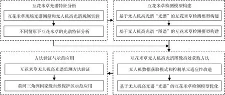
图1 总体技术路线图Fig. 1 The overall technical flowchart
2.2.1 互花米草地面光谱测量和无人机高光谱观测
在黄河三角洲互花米草分布区内开展互花米草地面光谱测量和无人机高光谱观测实验, 获得互花米草及其周边其他地物的地面光谱数据和无人机光谱数据,建立互花米草及其周边其他地物的光谱数据库, 记录光谱测量的日期、起止时间、经纬度、互花米草植株高度、叶片长度和宽度、植物间距、健康状况等信息, 并拍摄现场照片, 无人机测量时还要记录其飞行高度、观测角度、观测时刻等信息。而且, 要注意根据互花米草及其周边植被的物候差异、分布区域、生长状况等特点, 确保实验样区选择的典型性和全面性。
2.2.2 不同情形下互花米草的光谱特征分析
为使互花米草的光谱特征具有代表性, 分析互花米草的光谱特征时应考虑到各种情形, 主要有: (1)从互花米草自身考虑, 包括不同密度、不同生长状况等; (2)从无人机高光谱系统参数考虑, 包括无人机飞行高度、观测角度、观测时刻等; (3)从环境条件考虑,包括不同季节、不同潮汐状况、光照条件等。不同情形下互花米草的光谱特征都不尽相同, 应用互花米草的高光谱数据, 析取出互花米草的光谱曲线,分析互花米草的吸收位置、吸收深度、反射位置、反射高度等光谱特征。分析互花米草光谱特征随无人机飞行高度和观测角度、季节、潮汐状况、光照条件、互花米草密度和生长状况的变化规律, 对比互花米草与周边其他植被光谱特征的主要区别, 建立包含各种情形的互花米草光谱特征库。
2.3 基于无人机高光谱“光谱”和“图谱”的互花米草检测模型构建
实现互花米草无人机高光谱遥感监测的核心,是构建适用于不同观测条件和环境条件的鲁棒的互花米草检测模型。不同观测条件包括无人机飞行高度、观测角度等。不同环境条件包括光照条件、潮汐状况等。本研究拟分别构建基于无人机高光谱“光谱”和“图谱”的互花米草检测模型, 前者用于无人机飞行探测过程中的互花米草检测, 后者用于无人机高光谱图像获取后的互花米草检测, 技术路线如图2所示。
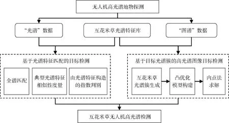
图2 基于无人机高光谱的互花米草检测模型构建技术路线图Fig. 2 The technical flowchart for constructing the Spartina alterniflora detection models based on UAV hyperspectral remote sensing
2.3.1 基于无人机高光谱“光谱”的互花米草检测模型构建
基于无人机高光谱“光谱”构建的互花米草检测模型主要是用于无人机飞行探测过程中在线检测互花米草, 要求其性能稳定、计算速度快且易于实现,因此采用领域内广泛应用的经典方法。本研究拟比较3种基于光谱特征匹配的目标检测方法: 光谱全谱匹配(将探测目标的光谱与互花米草光谱特征库中的光谱进行全谱比对, 根据二者的一致程度对探测目标进行判别)、典型光谱特征相似性度量(仅使用几个典型光谱特征进行探测目标与互花米草的特征相似性度量)、光谱特征构造指数判别(选择典型光谱特征构造一个指数, 利用数学统计方法, 确定构造指数的阈值, 以此来判别探测目标是否为互花米草), 选择最适于无人机在线实时检测的目标检测方法, 来构建基于无人机高光谱“光谱”的互花米草检测模型。
2.3.2 基于无人机高光谱“图谱”的互花米草检测
模型构建
本研究拟提出一种基于目标光谱簇的互花米草检测算法, 构建基于无人机高光谱“图谱”的互花米草检测模型, 该模型将在获取到无人机高光谱图像后使用, 用于互花米草高精度制图。首先对互花米草光谱特征库中的光谱进行去冗余、归类, 生成互花米草光谱簇; 通过自适应波束形成方法, 使用一个不等式约束来保证当目标光谱簇的光谱在一定范围内变化时, 提出的算法最小化输出能量, 这样即使目标光谱存在一定变化时, 其仍然能够被有效检测出来, 因而该方法对不同观测条件和环境条件造成的光谱变化具有鲁棒性。提出的算法将互花米草检测问题转化为一个凸优化问题, 其局部极小值就是全局极小值, 所以可以利用最优化方法来求出全局最优点, 本项目拟使用内点法来求解该最优化问题。
2.4 互花米草无人机高光谱图像高效获取方法研究
由于无人机每次飞行的续航时间有限, 且无人机高光谱图像后处理工作量大, 因此, 发展一种互花米草无人机高光谱图像高效获取方法是实现互花米草快速、准确检测的关键。互花米草无人机高光谱图像高效获取的研究思路为: 无人机高光谱进行地物探测时先仅获取地物的谱信息, 然后基于互花米草光谱特征库, 利用互花米草检测模型在线实时判定所探测地物是否为互花米草, 如果是, 再获取高光谱图像, 否则不获取, 技术路线图如图3所示。这种“先获取谱信息, 检测后再获取图像”的数据获取方式, 可使无人机每次飞行时探测更大的空间范围, 同时大大减少高光谱图像处理的工作量, 提高无人机高光谱互花米草检测效率。
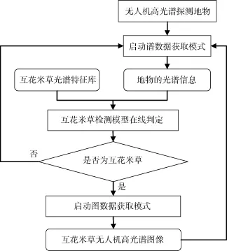
图3 互花米草无人机高光谱图像的高效获取方法研究技术路线图Fig. 3 The technical flowchart for studying an efficient acquisition method of UAV hyperspectral remote sensing images of Spartina alterniflora
实现互花米草无人机高光谱图像高效获取的核心是无人机数据获取模式和控制单元的适应性改造、所构建的基于无人机高光谱“光谱”的互花米草检测模型的优化改进。
2.4.1 无人机数据获取模式和控制单元适应性改造
目前, 无人机数据获取模式有谱模式、图模式、图谱模式, 本研究拟通过对无人机控制单元的适应性改造,实现无人机数据获取模式的自动选择与灵活切换。
2.4.2 基于无人机高光谱“光谱”的互花米草检测模型优化改进
研究无人机不同观测条件(飞行高度、观测角度等)和不同环境条件(光照条件、潮汐状况等)下互花米草检测模型的鲁棒性, 在此基础上对检测模型进行优化改进, 建立适用于无人机高光谱的互花米草在线检测模型, 应用于无人机高光谱飞行探测过程中。
2.5 互花米草无人机高光谱遥感监测方法验证与示范应用方案
本研究拟以黄河三角洲国家级自然保护区为研究区, 进行互花米草无人机高光谱遥感监测方法的验证与示范应用, 技术路线如图4所示。
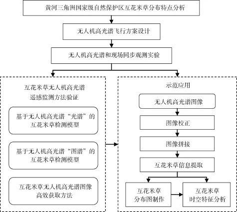
图4 互花米草无人机高光谱遥感监测方法验证与示范应用技术路线图Fig. 4 The technical flowchart for verifying and practically applying UAV hyperspectral remote sensing technology in Spartina alterniflora monitoring
2.5.1 互花米草无人机高光谱遥感监测方法验证
根据黄河三角洲国家级自然保护区互花米草的分布特点, 进行无人机高光谱飞行方案设计, 开展互花米草不同生长状况、不同观测条件、不同环境条件下的无人机高光谱和现场同步观测实验, 检验互花米草光谱特征库的完备性, 验证所构建的基于无人机高光谱“光谱”和“图谱”的互花米草检测模型的准确性和鲁棒性, 评价互花米草无人机高光谱图像高效获取方法的有效性。
2.5.2 黄河三角洲国家级自然保护区互花米草无人机高光谱遥感监测
对所获取的黄河三角洲国家级自然保护区互花米草无人机高光谱图像进行几何校正和图像拼接等影像后处理, 基于处理后的高光谱图像提取互花米草信息, 在此基础上, 制作黄河三角洲国家级自然保护区互花米草分布图, 分析黄河三角洲国家级自然保护区互花米草的时空分布特征。
3 总结与展望
外来入侵种互花米草分布在潮间带区域, 进入该区域现场困难——从陆上车下不去、从海上船上不来, 因此互花米草高效、准确监测一直是实际业务管理中的一个难题。然而, 互花米草空间分布状况和扩散动态信息却是业务管理中最需要的数据。无人机高光谱遥感是遥感技术发展的新方向和趋势, 具有可以灵活获取高空间、高光谱和高时间分辨率数据的优势, 本研究拟采用这种新型技术手段来进行互花米草遥感监测, 以期快速得到准确的互花米草信息, 为实际业务管理提供有效的技术支撑。
[1] Simenstad C A, Thom R M. Spartina alterniflora (smooth cordgrass) as an invasive halophyte in Pacific Northwest Estuaries[J]. Hortus Northwest, 1995, 6: 9-12, 38-40.
[2] Daehler C C, Strong D R. Status, prediction and prevention of introduced cordgrass Spartina spp. invasions in Pacific Estuaries, USA[J]. Biological Conservation, 1996, 78(1): 51-58.
[3] Jones C G, Lawton J H, Shachak M. Organisms as ecosystem engineers[J]. Oikos, 1994, 69(3): 373-386.
[4] Chung C H. Thirty years of ecological engineering with Spartina plantations in China[J]. Ecological Engineering, 1993, 2(3): 261-289.
[5] Chung C H, Zhuo R Z, Xu G W. Creation of Spartina plantations for reclaiming Dongtai, China, tidal flats and offshore sands[J]. Ecological Engineering, 2004, 23(3): 135-150.
[6] Mitsch W J, Lefeuvre J C, Bouchard V. Ecological engineering applied to river and wetland restoration[J]. Ecological Engineering, 2002, 18(18): 529-541.
[7] Weishar L L, Teal J M, Hinkle R. Designing large-scale wetland restoration for Delaware Bay[J]. Ecological Engineering, 2005, 25(3): 231-239.
[8] 王卿, 安树青, 马志军, 等. 入侵植物互花米草—生物学、生态学及管理[J]. 植物分类学报, 2006, 44(5): 559-588. Wang Qing, An Shuqing, Ma Zhijun, et al. Invasive Spartina alterniflora: biology, ecology and management[J]. Acta Phytotaxonomica Sinica, 2006, 44(5): 559-588.
[9] 唐廷贵, 张万钧. 论中国海岸带大米草生态工程效益与“生态入侵”[J]. 中国工程科学, 2003, 5(3): 15-20. Tang Tinggui, Zhang Wanjun. A discussion of ecological engineering benefits of Spartina spp. and its ecological invasion[J]. Engineering Science, 2003, 5(3): 15-20.
[10] 朱晓佳, 钦佩. 外来种互花米草及米草生态工程[J].海洋科学, 2003, 27(12): 14-19. Zhu Xiaojia, Qin Pei. The alien species Spartina alterniflora and Spartina ecoengineering[J]. Marine Sciences, 2003, 27(12): 14-19.
[11] 袁红伟, 李守中, 郑怀舟, 等. 外来种互花米草对中国海滨湿地生态系统的影响评价及对策[J]. 海洋通报, 2009, 28(6): 122-128. Yuan Hongwei, Li Shouzhong, Zheng Huaizhou, et al. Evaluation of the influences of foreign Spartina alterniflora on ecosystem of Chinese coastal wetland and its countermeasures[J]. Marine Science Bulletin, 2009, 28(6): 122-128.
[12] 欧健, 卢昌义. 厦门外来植物入侵风险评价指标体系的建立——以互花米草入侵风险评价为例[J]. 台湾海峡, 2006, 25(3): 437-444. Ou Jian, Lu Changyi. Establishment of risk assessment index system for alien plants in Xiamen: case study of smooth cordgrass[J]. Journal of Oceanology in Taiwan Strait, 2006, 25(3): 437-444.
[13] 中华人民共和国环境保护部.关于发布中国第一批外来入侵物种名单的通知[EB/OL]. [2003-01-10]. http: // www.zhb.gov.cn/gkml/zj/wj/200910/t20091022_17215 5.htm. Ministry of Environmental Protection of the People’s Republic of China. Notice on releasing the first batch external invasion species name list in China[EB/OL]. [2003-01-10].http: //www.zhb.gov.cn/gkml/zj/wj/200910/ t20091022_172155.htm.
[14] 张帆, 刘长安, 姜洋. 滩涂盐沼湿地退化机制研究[J].海洋开发与管理, 2008, 8: 99-101. Zhang Fan, Liu Changan, Jiang Yang. Research on degradation mechanism of tidal saltmarsh wetland[J]. Marine development and management, 2008, 8: 99-101.
[15] 李加林. 基于MODIS的沿海带状植被NDVI/EVI季节变化研究—以江苏沿海互花米草盐沼为例[J]. 海洋通报, 2006, 25(6): 91-96. Li Jialin. Research on the seasonal dynamics of zonal vegetation in the coastal area using MODIS-NDVI/EVI: A case study of Spartina alterniflora marsh on the Jiangsu coast[J]. Marine Science Bulletin, 2006, 25(6): 91-96.
[16] 李加林, 张忍顺. 互花米草海滩生态系统服务功能及其生态经济价值的评估—以江苏为例[J]. 海洋科学, 2003, 27(10): 68-72. Li Jialin, Zhang Renshun. Function of Spartina alterniflora salt marsh ecosystem services and evaluation of their ecological and economical value: a case of Jiangsu Province[J]. Marine Sciences, 2003, 27(10): 68-72.
[17] 刘春悦, 张树清, 江红星, 等. 江苏盐城滨海湿地外来种互花米草的时空动态及景观格局[J]. 应用生态学报, 2009, 20(4): 901-908. Liu Chunyue, Zhang Shuqing, Jiang Hongxing, et al. Spatiotemporal dynamics and landscape pattern of alien species Spartina alterniflora in Yancheng coastal wetlands of Jiangsu Province, China[J]. Chinese Journal of Applied Ecology, 2009, 20(4): 901-908.
[18] 刘永学, 陈君, 张忍顺, 等. 江苏海岸盐沼植被演替的遥感图像分析[J]. 农村生态环境, 2001, 17(3): 39-41. Liu Yongxue, Chen Jun, Zhang Renshun, et al. Analysis of remote sensing images for vegetation succession on tidal saltmarsh in Jiangsu[J]. Rural Eco-Environment, 2001, 17(3): 39-41.
[19] 刘永学, 李满春, 张忍顺. 江苏沿海互花米草盐沼动态变化及影响因素研究[J]. 湿地科学, 2004, 2(2): 116-121. Liu Yongxue, Li Manchun, Zhang Renshun. Approach on the dynamic change and influence factors of Spartina alterniflora Loisel saltmarsh along the coast of the Jiangsu Province[J]. Wetland Science, 2004, 2(2): 116-121.
[20] 刘永学, 张忍顺, 李满春. 江苏沿海互花米草盐沼动态变化及影响因素研究[J]. 海洋地质动态, 2004, 20(2): 18-21. Liu Yongxue, Zhang Renshun, Li Manchun. Approach on the dynamic change and influence factors of Spartina alterniflora Loisel saltmarsh along the coast of the Jiangsu Province[J]. Marine Geology Letters, 2004, 20(2): 18-21.
[21] 沈永明, 刘咏梅, 陈全站. 江苏沿海互花米草盐沼扩张过程的遥感分析[J]. 植物资源与环境学报, 2002, 11(2): 33-38. Shen Yongming, Liu Yongmei, Chen Quanzhan. Analysis of the expanding process of the Spartina alterniflora Loisel salt marsh on Jiangsu province coast by remote sensing[J]. Journal of Plant Resource and Environment, 2002, 11(2): 33-38.
[22] 姚懿函, 清华, 安树青, 等. 不同建群时间下互花米草种群生长及生物量分配[J]. 生态学报, 2010, 30(19): 5200-5208. Yao Yihan, Qing Hua, An Shuqing, et al. Growth and biomass allocation of differently-aged populations of Spartina alterniflora[J]. Acta Ecologica Sinica, 2010, 30(19): 5200-5208.
[23] 张忍顺, 沈永明, 陆丽云, 等. 江苏沿海互花米草盐沼的形成过程[J]. 海洋与湖沼, 2005, 36(4): 358-366. Zhang Renshun, Shen Yongming, Lu Liyun, et al. Formation of Spartina alterniflora salt marsh on Jiangsu coast, China[J]. Oceanologia et Limnologia Sinica, 2005, 36(4): 358-366.
[24] 张华兵, 刘红玉, 侯明行. 人工管理和自然驱动下盐城海滨湿地互花米草沼泽演变及空间差异[J]. 生态学报, 2013, 33(15): 4767-4775. Zhang Huabing, Liu Hongyu, Hou Minghang. Spatiotemporal characteristics of Spartina alterniflora marsh change in the coastal wetlands of Yancheng caused by natural processes and human activities[J]. Acta Ecologica Sinica, 2013, 33(15): 4767-4775.
[25] 黄华梅, 张利权, 高占国. 上海滩涂植被资源遥感分析[J]. 生态学报, 2005, 25(10): 2686-2693. Huang Huamei, Zhang Liquan, Gao Zhanguo. The vegetation resource at the intertidal zone in Shanghai using remote sensing[J]. Acta Ecologica Sinica, 2005, 25(10): 2686-2693.
[26] 黄华梅, 张利权. 上海九段沙互花米草种群动态遥感研究[J]. 植物生态学报, 2007, 31(1): 75-82. Huang Huamei, Zhang Liquan. Remote sensing analysis of range expansion of Spartina alterniflora at Jiuduansha shoals, Shanghai, China[J]. Journal of Plant Ecology(Chinese Version), 2007, 31(1): 75-82.
[27] Huang H, Zhang L. A study of the population dynamics of Spartina alterniflora at Jiuduansha shoals, Shanghai, China[J]. Ecological Engineering, 2007, 29(2): 164-172.
[28] 李贺鹏, 张利权, 王东辉. 上海地区外来种互花米草的分布现状[J]. 生物多样性, 2006, 14(2): 114-120. Li Hepeng, Zhang Liquan, Wang Donghui. Distribution of an exotic plant Spartina alterniflora in Shanghai[J]. Biodiversity Science, 2006, 14(2): 114-120.
[29] 刘瑜, 韩震. 基于遥感的长江口南汇潮滩植被群落时空动态变化[J]. 上海海洋大学学报, 2009, 18(5): 579-585. Liu Yu, Han Zhen. The study of spatial and temporal variations on vegetation communities in Nanhui tidal flat of Changjiang Estuary by using remote sensing[J]. Journal of Shanghai Ocean University, 2009, 18(5): 579-585.
[30] 沈芳, 周云轩, 张杰, 等. 九段沙湿地植被时空遥感监测与分析[J]. 海洋与湖沼, 2006, 37(6): 498-504. Shen Fang, Zhou Yunxuan, Zhang Jie, et al. Remote sensing analysis on spatial-temporal variation in vegetation on Jiuduansha wetland[J]. Oceanologia et Limnologia Sinica, 2006, 37(6): 498-504.
[31] 王东辉, 张利权, 管玉娟. 基于CA模型的上海九段沙互花米草和芦苇种群扩散动态[J]. 应用生态学报, 2007, 18(12): 2807-2813. Wang Donghui, Zhang Liquan, Guan Yujuan. Population expansion of Spartina alterniflora and Phragmites australis at Jiuduansha, Shanghai based on cellular automata model[J]. Chinese Journal of Applied Ecology, 2007, 18(12): 2807-2813.
[32] 张东, 杨明明, 李俊祥, 等. 崇明东滩互花米草的无性扩散能力[J]. 华东师范大学学报(自然科学版), 2006, 3(2): 130-135. Zhang Dong, Yang Mingming, Li Junxiang, et al. Vegetative dispersal ability of Spartina alterniflora in eastern end of Chongming Island[J]. Journal of East China Normal University(Natural Science), 2006, 3(2): 130-135.
[33] Zhang Wenlong, Zeng Congsheng, Tong Chuan, et al. Analysis of the expanding process of the Spartina alterniflora salt marsh in Shanyutan wetland, Minjiang River estuary by remote sensing[J]. Procedia Environmental Sciences, 2011, 10(1): 2472-2477.
[34] 方民杰. 福建沿岸海域互花米草的分布[J]. 台湾海峡, 2012, 31(1): 100-104. Fang Minjie. Distribution of Spartina alterniflora in Fujian coast waters[J]. Journal of Oceanography in Taiwan Strait, 2012, 31(1): 100-104.
[35] 潘卫华, 陈家金, 李丽纯, 等. 福建罗源湾互花米草的遥感动态监测[J]. 中国农学通报, 2009, 25(13): 216-219. Pan Weihua, Chen Jiajin, Li Lichun, et al. Dynamical monitoring of Spartina alterniflora invasion by using remote sensing data in Luoyuan Bay, Fujian[J]. Chinese Agricultural Science Bulletin, 2009, 25(13): 216-219.
[36] 潘卫华, 陈家金, 张春桂, 等. 福建沿海水域互花米草蔓延的动态监测分析[J]. 中国农学气象, 2011, 32(增1): 174-177. Pan Weihua, Chen Jiajin, Zhang Chungui, et al. Dynamic monitoring analysis of expansion of Spartina alterniflora in Fujian[J]. Chinese Journal of Agrometeorology, 2011, 32(suppl.1): 174-177.
[37] 孙飒梅. 三都湾互花米草的遥感监测[J]. 台湾海峡, 2005, 24(2): 223-227. Sun Samei. Monitoring of smooth cordgrass invasion by remote sensing in Sandu Bay, Fujian[J]. Journal of Oceanography in Taiwan Strait, 2005, 24(2): 223-227.
[38] 吴德力, 沈永明, 杜永芬, 等. 福建省罗源湾互花米草扩展过程及其特征分析[J]. 海洋学报, 2013, 35(6): 113-120. Wu Deli, Shen Yongming, Du Yongfen, et al. The expanding process and characteristics of Spartina alterniflora in Luoyuan Bay of Fujian Province, China[J]. Acta Oceanologica Sinica(in China), 2013, 35(6): 113-120.
[39] 刘海华, 李玉宝. 1993—2003年间温州沿海互花米草变迁[J]. 温州大学学报·自然科学版, 2007, 28(5): 19-24. Liu Haihua, Li Yubao. Variation of the Spartina alterniflora Loisel along coastal Wenzhou as aided by TM images[J]. Journal of Wenzhou University·Natural Sciences, 2007, 28(5): 19-24.
[40] Wang Anqi, Chen Jiadai, Jing Changwei, et al. Monitoring the invasion of Spartina alterniflora from 1993 to 2014 with Landsat TM and SPOT 6 satellite data in Yueqing Bay, China[J]. Plos One, 2015, 10(8): e0135538.
[41] 任广波, 刘艳芬, 马毅, 等. 现代黄河三角洲互花米草遥感监测与变迁分析[J]. 激光生物学报, 2014, 23(6): 515-523. Ren Guangbo, Liu Yanfen, Ma Yi, et al. Spartina alterniflora monitoring and change analysis in Yellow River delta by remote sensing technology[J]. Acta Laser Biology Sinica, 2014, 23(6): 515-523.
[42] 章莹, 卢剑波. 外来入侵物种互花米草(Spartina alterniflora)及凤眼莲(Eichhornia crassipes)的遥感监测研究进展[J]. 科技通报, 2010, 26(1): 130-137. Zhang Ying, Lu Jianbo. Progress on monitoring of two invasive species smooth cordgrass (Spartina alterniflora) and water hyacinth (Eichhornia crassipes) by remote sensing[J]. Bulletin of Science and Technology, 2010, 26(1): 130-137.
[43] 吕厚谊. 无人机发展与无人机技术[J]. 世界科技研究与发展, 1998, 6: 113-116. Lü Houyi. UAV development and UAV technology[J]. World Science and Technology Research and Development, 1998, 6: 113-116.
[44] 范承啸, 韩俊, 熊志军, 等. 无人机遥感技术现状与应用[J]. 测绘科学, 2009, 34(5): 214-215. Fan Chengxiao, Han Jun, Xiong Zhijun, et al. Application and status of unmanned aerial vehicle remotesensing technology[J]. Science of Surveying and Mapping, 2009, 34(5): 214-215.
[45] Corcoles J I, Ortega J F, Hernandez D, et al. Use of digital photography from unmanned aerial vehicles for estimation of leaf area index in onion[J]. European Journal of Agronomy, 2013, 45: 96-104.
[46] Herwitz S R, Johnson L F, Dunagan S E. Imaging from an unmanned aerial vehicle: agricultural surveillance and decision support[J]. Computers and Electronics in Agricultural, 2004, 44(1): 49-61.
[47] Mcgill P R, Reisenbichler K R, Etchemendy S A, et al. Aerial surveys and tagging of free-drifting icebergs using an unmanned aerial vehicle (UAV)[J]. Deep Sea Research Part II Topical Studies in Oceanography, 2011, 58(11): 1318-1326.
[48] 张良培, 张立福. 高光谱遥感[M]. 北京: 测绘出版社, 2011. Zhang Liangpei, Zhang Lifu. Hyperspectral Remote Sensing[M]. Beijing: Surveying and Mapping Publishing House, 2011.
[49] Pengra B W, Johnston C A, Loveland T R. Mapping an invasive plant, Phragmites australis, in coastal wetlands using the EO-1 Hyperion hyperspectral sensor[J]. Remote Sensing of Environment, 2007, 108(1): 74-81.
[50] Zomer R J, Trabucco A, Ustin S L. Building spectral libraries for wetlands land cover classification and hyperspectral remote sensing[J]. Journal of Environmental Management, 2009, 90(7): 2170-2177.
[51] Bertels L, Houthuys R, Sterckx S, et al. Large-scale mapping of the riverbanks, mud flats and salt marshes of the Scheldt basin using airborne imaging spectroscopy and LiDAR[J]. International Journal of Remote Sensing, 2011, 32(10): 2905-2918.
[52] 崔宾阁, 庄仲杰, 任广波, 等. 典型高光谱图像端元提取算法在黄河口湿地应用评价研究[J]. 海洋科学, 2015, 39(2): 104-109. Cui Bin’ge, Zhuang Zhongjie, Ren Guangbo, et al. Evaluation of the prime hyperspectral endmember extraction algorithm in Yellow River Estuarine wetland[J]. Marine Sciences, 2015, 39(2): 104-109.
[53] 李晓敏, 张杰, 马毅, 等. 基于主成分分析和决策级融合的高光谱图像分类方法研究[J]. 海洋科学, 2015, 39(2): 25-34. Li Xiaomin, Zhang Jie, Ma Yi, et al. Research on the classification method of the hyper-spectral image based on principal component analysis and decision-level fusion[J]. Marine Sciences, 2015, 39(2): 25-34.
[54] 马毅, 张杰, 任广波, 等. 基于决策级数据融合的CHRIS高光谱图像分类方法研究[J]. 海洋科学, 2015, 39(2): 8-14. Ma Yi, Zhang Jie, Ren Guangbo, et al. Research on decision-level data fusion classification method for CHRIS hyperspectral imagery[J]. Marine Sciences, 2015, 39(2): 8-14.
[55] 吴培强, 张杰, 马毅, 等. 基于地物光谱可分性的CHRIS高光谱影像波段选择及其分类应用[J]. 海洋科学, 2015, 39(2): 20-24. Wu Peiqiang, Zhang Jie, Ma Yi, et al. A CHRIS hyperspectral band selection method based on spectral separability and classification application[J]. Marine Sciences, 2015, 39(2): 20-24.
[56] Zhang Caiyun, Xie Zhixiao. Combining object-based texture measures with a neural network for vegetation mapping in the Everglades from hyperspectral imagery[J]. Remote Sensing of Environment, 2012, 124(124): 310-320.
[57] Ma Yi, Zhang Jie, Cui Tingwei, et al. A preliminary research on dominant species identification of red tide organism by airborne hyperspectral technique[J]. SPIE, 2003, 4892: 278-286.
[58] 马毅, 张杰, 崔廷伟. 基于SVM 方法的赤潮生物优势种航空高光谱识别[J]. 光谱学与光谱分析, 2006, 26(12): 2302-2305. Ma Yi, Zhang Jie, Cui Tingwei. Research in airborne hyperspectral identification of Red Tide organism dominant species based on SVM[J]. Spectroscopy and Spectral Analysis, 2006, 26(12): 2302-2305.
[59] Calderon R, Navas-Cortes J A, Lucena C, et al. High-resolution airborne hyperspectral and thermal imagery for early detection of verticillium wilt of olive using fluorescence, temperature and narrow-band spectral indices[J]. Remote Sensing of Environment, 2013, 139(139): 231-245.
[60] Zarco-Tejada P J, Gonzalez-Dugo V, Berni J A J. Fluorescence, temperature and narrow-band indices acquired from a UAV platform for water stress detection using a micro-hyperspectral imager and a thermal camera[J]. Remote Sensing of Environment, 2012, 117(1): 322-337.
[61] Zarco-Tejada P J, Guillen-Climent M L, Hernandez-Clemente R, et al. Estimating leaf carotenoid content in vineyards using high resolution hyperspectral imagery acquired from an unmanned aerial vehicle (UAV)[J]. Agricultural and Forest Meteorology, 2013, 171(8): 281-294.
[62] Zarco-Tejada P J, Morales A, Testi L, et al. Spatio-temporal patterns of chlorophyll fluorescence and physiological and structural indices acquired from hyperspectral imagery as compared with carbon fluxes measured with eddy covariance[J]. Remote Sensing of Environment, 2013, 133(12): 102-115.
[63] Zarco-Tejada P J, Catalina A, Gonzalez M R, et al.Relationships between net photosynthesis and steady-state chlorophyll fluorescence retrieved from airborne hyperspectral imagery[J]. Remote Sensing of Environment, 2013, 136(136): 247-258.
[64] Duan Sibo, Li Zhaoliang, Wu Hua, et al. Inversion of the PROSAIL model to estimate leaf area index of maize, potato and sunflower fields from unmanned aerial vehicle hyperspectral data[J]. International Journal of Applied Earth Observation and Geoinformation, 2014, 26(2): 12-20.
Study on monitoring alien invasive species Spartina alterniflora using unmanned aerial vehicle hyperspectral remote sensinga case study of the Yellow River Delta
LI Xiao-min1,2, ZHANG Jie1, MA Yi1, REN Guang-bo1
(1. First Institute of Oceanography, State Oceanic Administration, Qingdao 266061, China; 2. School of Life Sciences, Inner Mongolia University, Hohhot 010021, China)
Nov. 2, 2016
Spartina alterniflora; unmanned aerial vehicle (UAV); hyperspectral remote sensing
The invasion of Spartina alterniflora is immensely dominant, hence it has been included in the priority list of invasive species. The large-scale spread of S. alterniflora has severely influenced the growth and distribution of the native species, hence the relevant management departments are urgently required to monitor the spatial distribution and spread of S. alterniflora, but currently there are no effective ways of monitoring. Hence, we propose a new method of monitoring S. alterniflora using unmanned aerial vehicle (UAV) hyperspectral remote sensing, a new technical means of remote sensing monitoring, to analyze the spectral characteristics of S. alterniflora under different circumstances (such as growth status and environmental conditions). The technique will establish a robust S. alterniflora remote sensing detection model, to find an effective way to obtain UAV hyperspectral remote sensing images of S. alterniflora, and then to achieve efficient and accurate monitoring of S. alterniflora. The results can provide an effective technical means for the operational S. alterniflora monitoring.
TP79
A
1000-3096(2017)04-0098-10
10.11759/hykx20161102002
(本文编辑: 刘珊珊)
2016-11-02;
2016-12-26
国家自然科学基金(61601133)
[Foundation: National Natural Science Foundation of China, No. 61601133]
李晓敏(1982-), 女, 蒙古族, 内蒙古通辽人, 助理研究员,硕士, 主要从事海岸带生态遥感方面的研究, 电话: 0532-88960569, E-mail: lixiaomin@fio.org.cn
猜你喜欢
农业灾害研究(2022年7期)2022-09-08
北京航空航天大学学报(2022年8期)2022-08-31
安徽农业科学(2022年14期)2022-08-04
海洋通报(2021年5期)2021-12-21
今日农业(2021年17期)2021-11-26
空间科学学报(2021年1期)2021-05-22
能源与环境(2020年4期)2020-09-02
互联网天地(2016年2期)2016-05-04
互联网天地(2016年1期)2016-05-04
中国光学(2015年5期)2015-12-09
