
防护性景观规划—气候变暖“护盾”
2018-03-11 01:49盖伦纽曼乔紫旭
城市设计 2018年5期
盖伦·纽曼 乔紫旭
1 背 景
无论在生态、社会还是经济方面,气候变化都对建筑环境产生了巨大的影响。美国国家海洋和大气管理局(NOAA)预测,墨西哥湾沿岸地区的平均海平面每年至少要上升0.2cm,到2100年将达到1.9m。一直以来,海平面上升都对沿海生态系统产生了重大影响,包括湿地丧失、海岸侵蚀或淹没,飓风的持续时间和频率也大幅增加。例如,在2008年,飓风艾克(Hurricane Ike)对德克萨斯造成了严重的破坏,造成113人死亡和约295亿美元的经济损失,大约200个位于德克萨斯州联盟城(League City,Texas)的房屋受到了严重损害。
由于联盟城近墨西哥湾的地理位置,其城市面临着诸多自然灾害,并且非常容易受到洪水事件和海平面上升等其他问题带来的影响。该设计项目位于联盟城市内靠近河岸的一块39公顷的闲置土地。设计目标是通过“护盾工具包”的应用,使社区可以尽可能地避免受到当前和未来的洪水灾害以及由大气变暖、海平面上升所带来的影响,从而降低社区及整个联盟城的生态环境脆弱性和社会经济脆弱性(图1—图16)。
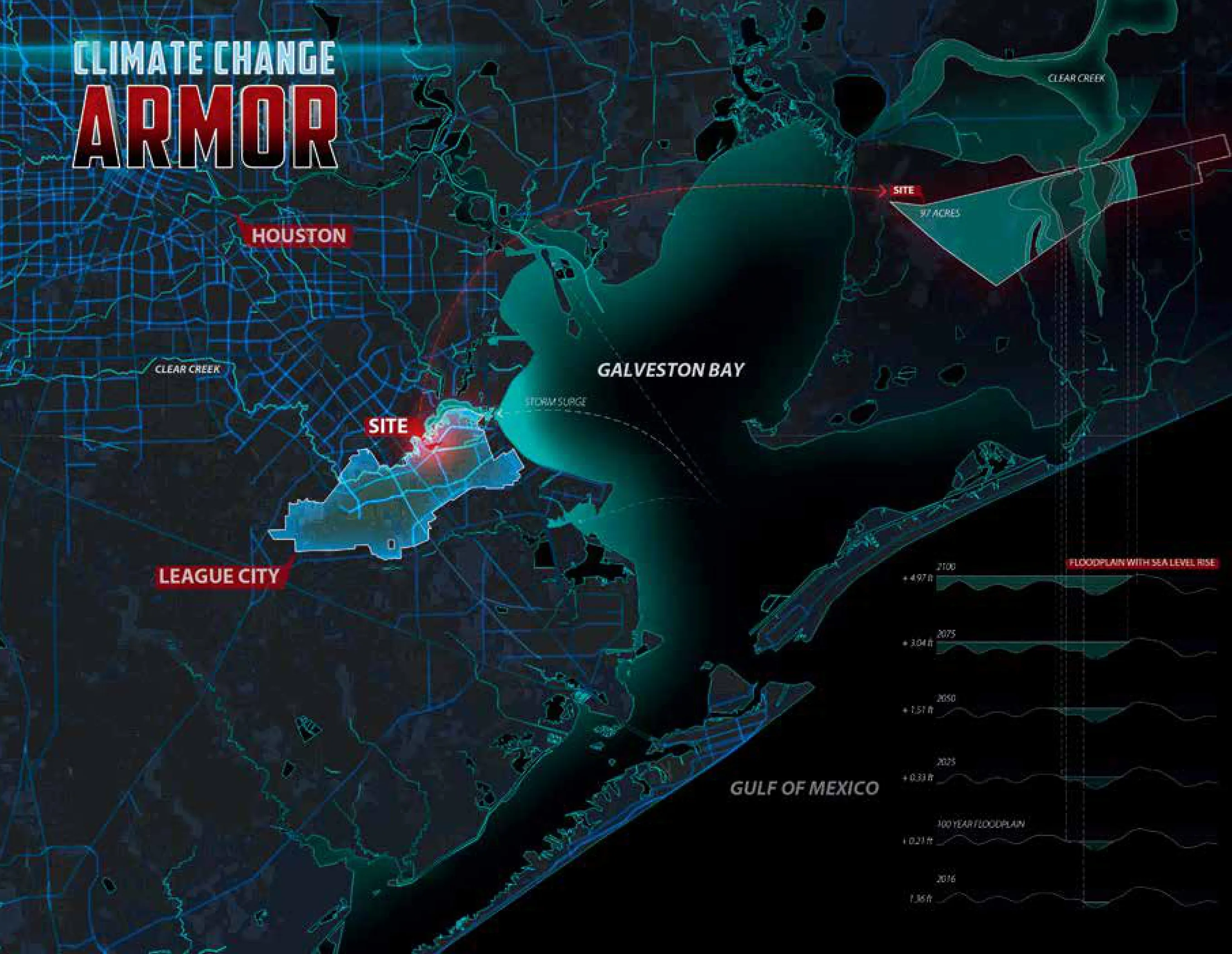
图1 / Figure 1气候变暖“护盾”/ Climate Change Armor
2 区域和场地条件
洪水和飓风一直是墨西哥湾沿岸面临的主要问题。德克萨斯州沿岸遭遇普通飓风的频率大约是每5年一次,遭遇大型飓风的频率大约为每15年一次。3级以上的飓风带来的洪水就可将设计场地大面积淹没。与此同时,海平面上升也会增加沿海社区面对洪水和飓风等灾害的社会经济脆弱性。据联邦紧急事务管理局(FEMA)预测,到2100年,近50%的联盟城用地将无法抵御百年一遇的洪水,同时1.9m的海平面上升意味着76%的项目土地将被洪水淹没,并且完全无法抵御500年一遇的大型洪水。通过在GIS中叠加社会和经济栅格数据集来绘制导致洪水脆弱性因素的地图,得到超过41%的联盟城用地处于相对高度的洪水脆弱性区域的结论,而项目场地正处于该区域。此外,鉴于以上因素对生态系统造成的灾难性破坏,在过去的20年里,该项目场地已经失去了近43%的湿地面积。
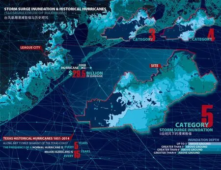
图2 / Figure 2台风暴潮漫滩数值与历史飓风 / Storm surge inundation&historical hurricanes
3 设计策略
通过借鉴国内和国际的弹性社区设计案例,该设计开发并整合了一个适应性洪水衰减机制(结构和非结构)—气候变暖“护盾工具包”。结构机制是以工程方法为基础设施,主要用于阻止和控制洪水,分为如下几种。
干线护盾:高架公路,兼作一体化防洪墙;
堤坝护盾:植被覆盖的斜坡,模仿天然堤坝;
闸门护盾:小型防洪闸门,可在上游洪水发生时关闭;
建筑护盾:建在桩柱上的高架建筑。
非结构性机制主要依靠自然系统和绿色基础设施来减少洪水、储存雨水并减轻频繁洪水事件带来的潜在影响。分为如下几种。
滨水保留带护盾:一系列保存完好的湿地和植被的滨水边缘;
疏浚护盾:在河岸挖掘沉积物来储存洪水;
生态调节沟护盾:输送雨水至渗透和过滤雨水区域的街道与市政设施。
气候变暖“护盾工具包”被适应性地应用于场地的不同区域,使场地自身变成了一个坚固的护盾,在避免当前和未来洪水问题的同时为居民提供了娱乐、住房和经济机会。与现有河畔接壤的设计绿地既保护了社区免受洪水侵袭,又被设计成一个具有露天剧场、休闲码头、河畔酒店和其他文化设施的公园。它通过生态调节沟、高架林荫小径和生态堤坝等形成相互连接的绿色基础设施系统;同时基于工程建设的住宅区、商业空间和道路交通也可作为多功能保护结构,从而减少该地区面对洪涝灾害的生态脆弱性和社会经济脆弱性(physical and social vulnerability)。
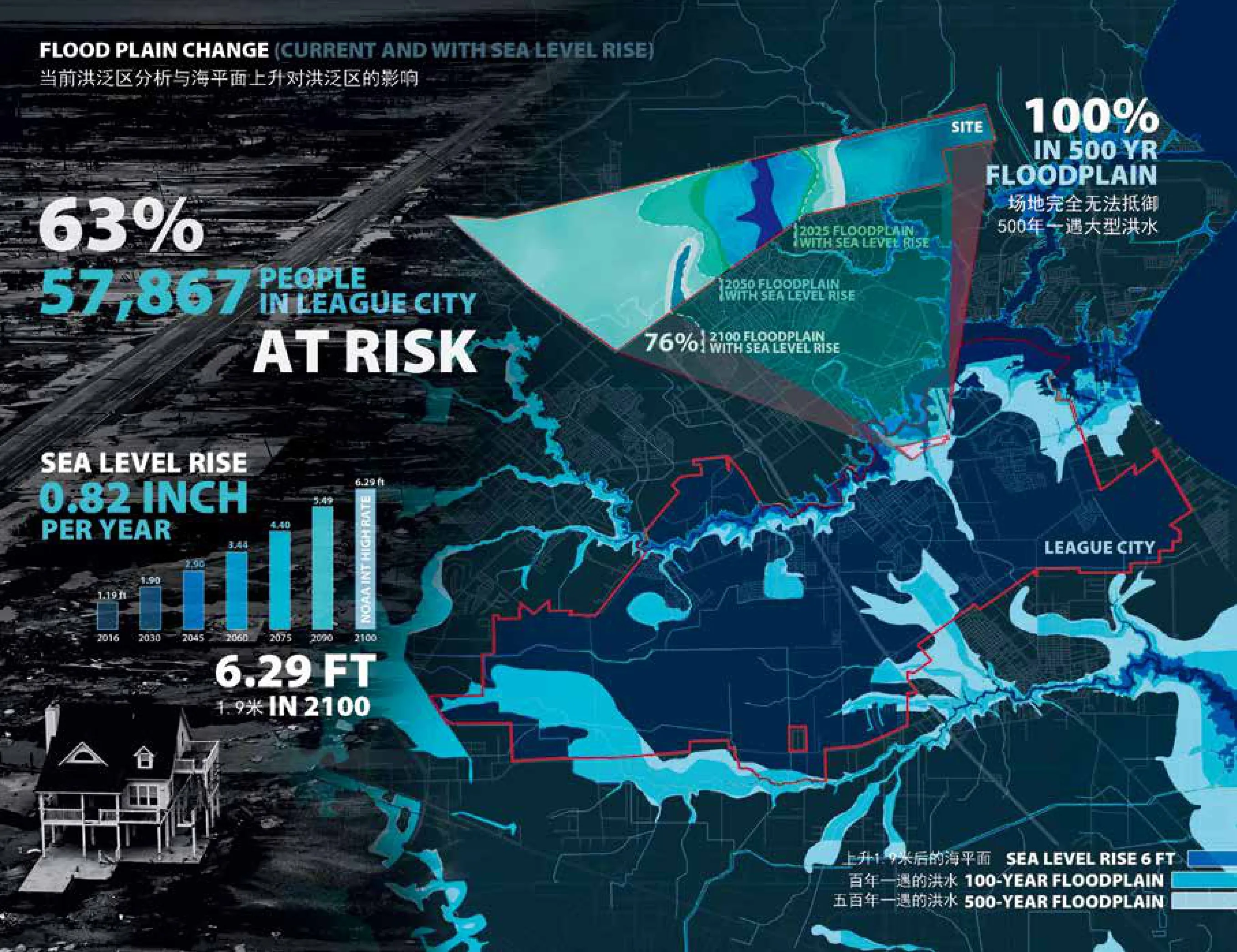
图3 / Figure 3当前洪泛区分析与海平面上升对洪泛区的影响 / Current Flood plain change with sea level rise
该设计将分3个阶段实施。
一期:远离洪水。
重点开发位于场地两侧海拔较高的地区,同时将绿色基础设施的开发和整合与之配套。一期开发的商业区和商住混用区域将与周边已有的高密度住宅商务区相连,并且有策略地放置在洪水易发区域之外,从而降低该区域面对洪涝灾害的生态脆弱性。具有景观特征和可渗透铺装的公共城市空间不仅起到了储存、渗透和过滤雨水的作用,还促进了邻里间的联系。
二期:缓解洪水。
开发低密度住宅区和公共服务设施,安置绿色基础设施,保护居民区免受频繁的暴风雨带来的灾难;同时,开启工程基础设施,以应对更大的洪水事件带来的灾害。多样的住房类型带来了不同年龄阶段和背景的居民。公共服务设施用地将建设气候变化博物馆等公共建筑,为居民提供了参与和教育机会。
三期:控制洪水。
完成全部工程基础设施建设,以创建一个完整的、多功能的“护盾”系统,可在极端洪水灾难时阻止和控制洪水并调节水文活动。同时,形成一个相互连接的交通系统(包括河滨步道、人行天桥、自行车道、河上游憩设施等),以增强居民与公园的联系、吸引游客,也制造了经济和就业机会。
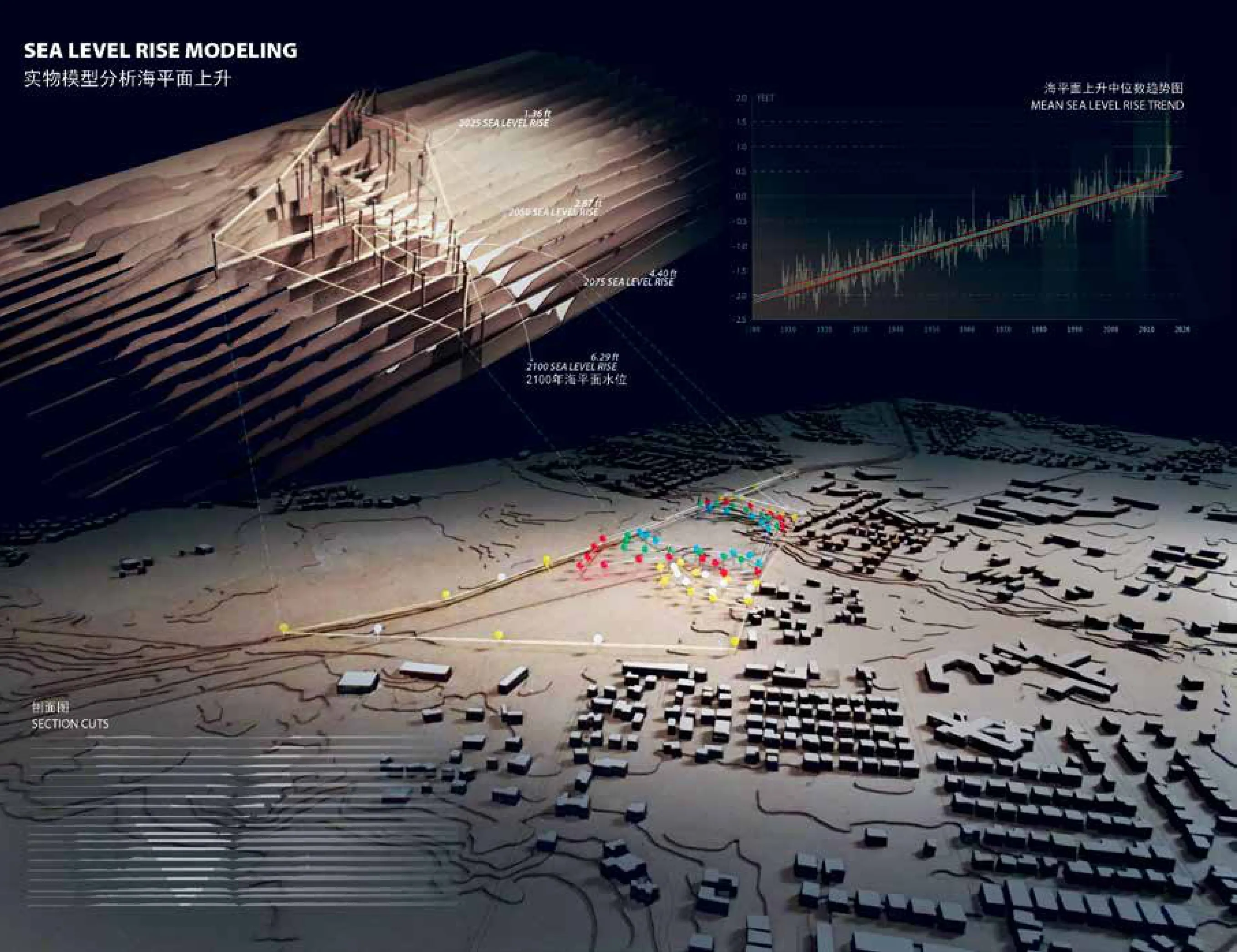
图4 / Figure 4实物模型分析海平面上升 / Sea level rise modeling
4 设计效益评估
结构与非结构“护盾”根据其功能被应用于场地的不同位置,以保护当地居民的生命与财产,并创造生态和经济效益。最后National Green Values™计算器用于评估设计中使用的绿色基础设施的性能、成本和效益。与传统方法相比,绿色基础设施将场地的不渗透面积减少了26%,占据了所需径流量的30.3%。同时,该设计可以捕获6,230m3的径流,通过减少空气污染物和能源使用、处理污染物、增加二氧化碳吸取量、提高树木的补偿价值和改善地下水补给,每年将创造42万美元的绿色效益。
气候变暖“护盾”设施不仅可以创造经济和生态效益,还可以创造巨大的文化和社会效益。通过“护盾”的应用,该设计在2100年之前将大幅减少100年的洪泛区,海平面上升造成的覆盖面积将从30公顷减少到6公顷(从76%覆盖到仅16%)。此外,近2,400名新居民受到保护,3,000多个工作岗位被创造,避免了约2,300万美元的直接损失,到2,100年场地将共创造近13亿美元的生命周期效益。
FULL TEXTS IN ENGLISH
Project Title: Climate Change Armor
Galen Newman, QIAO Zixu
1 Background / Problem Statement
Climate change effects have had observable ecological, social, and economic impacts on thebuilt environment. NOAA predicts that the mean sea level will rise at least 0.82 inches per year in the Gulf Coast region, reaching 6.29 feet by 2100. Sea level rise has had a signi ficant impact on coastal ecosystems resulting in wetland loss, increased coastal erosion/inundation, and increases in the duration and frequency offlooding from storm surge. For example, in 2008,Hurricane Ike wreaked havoc on Texas, causing 113 deaths and $29.5 billion in damage; approximately 200 of the damaged homes were located in League City, Texas.
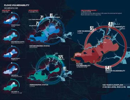
图5 / Figure 5洪水脆弱性分析 / Flood Vulnerability
Due to its location, League City is exposed to many hazards and is highly vulnerable to flood events and other issues effected by sea level rise. This project designs a resilient community within a 97-acre site surrounded by urban development in League City. The site is currently planned bythe city to grow as mixeduse and auto dominated residential urban low density development. The objective of this project is to design a community that is fully protected from current and future flood events and the eventual impacts of sea level rise,thereby reducing physical and social vulnerability.
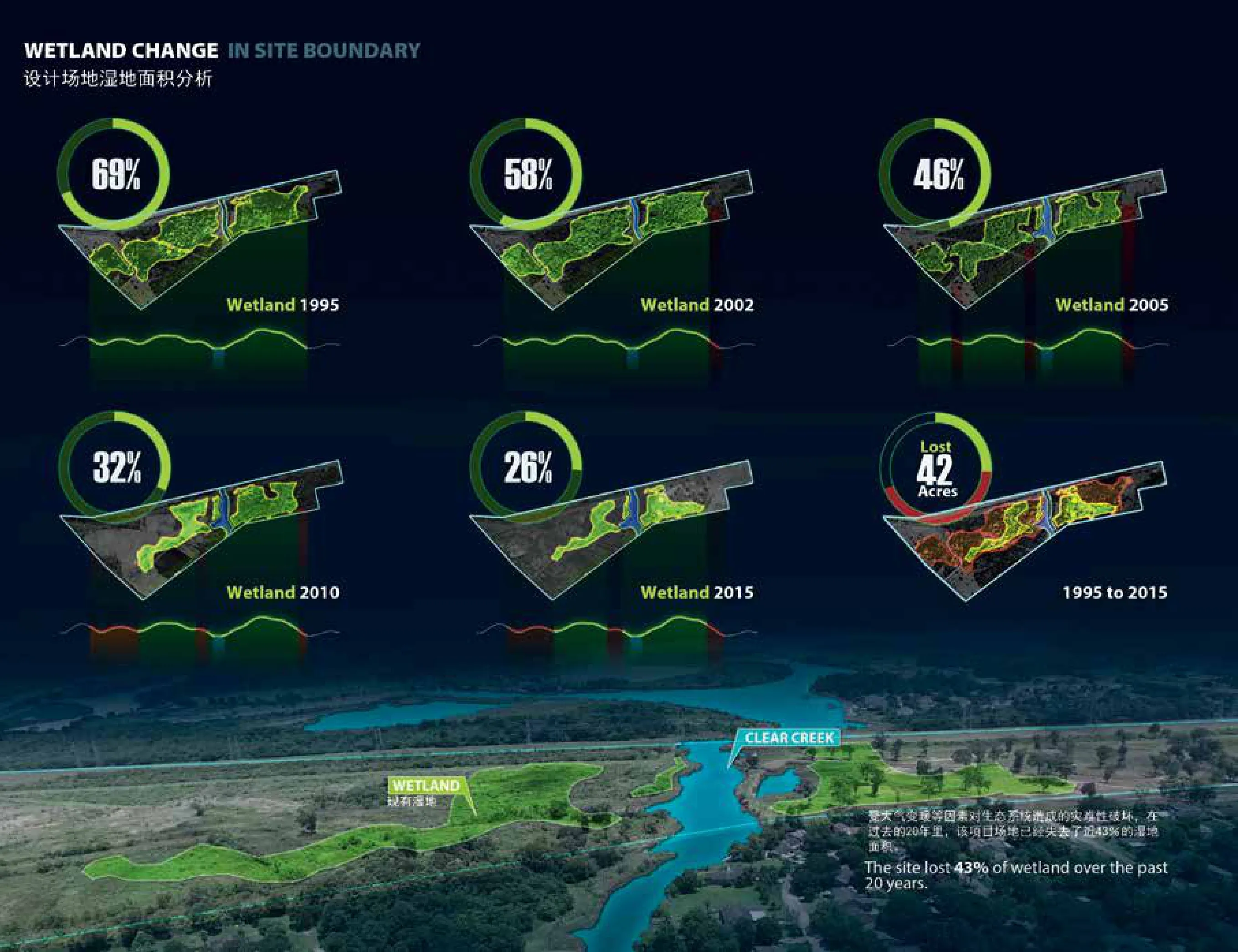
图6 / Figure 6设计场地湿地面积分析 / Wetland change in site boundary
2 Regional & Site Conditions
Flooding and hurricanes are major concerns along the Gulf Coast. The frequency of a normal hurricane along any 50 mile segment of the Texas coast is one about every 5 years,with a major hurricane occurring nearly every 15 years. The design site will be significantly inundated by storm surge from hurricanes from Category 3 and above. Relatedly, sea level rise will increase the vulnerability of coastal communities to hazards such as flooding and hurricanes. By 2100, nearly 50% of League City projects to be covered by the FEMA 100 year floodplain, should a 6 feet sea level rise occur; 76% of the land on the design site will be effected, and the entire site is covered by the 500 year floodplain. By overlaying social and economic raster data sets in GIS to map factors contributing to flood vulnerability, over 41% of League City projects to have high flood vulnerability, and the site rests as the highest flood vulnerable area in the city. In regards to the catastrophic damage these conditions have had on ecosystems, nearly 96 acres offreshwater wetlands and 154 acres of wetlands in the region have been lost since 2008. The design site has lost 43% of its wetland area in the past 20 years.
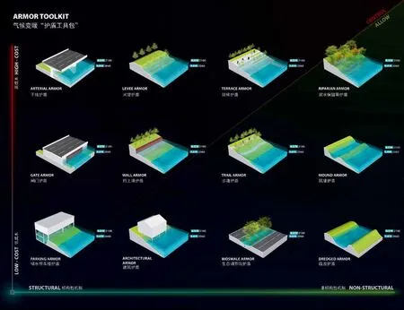
图7 / Figure 7气候变暖“护盾工具包” / Armor Toolkit
3 Design Strategy
Borrowing from a series of resilient community design cases nationally and internationally, this design develops and incorporates a series of adaptable flood attenuation mechanisms (both structural and non-structural),referred to as the Climate Change Armor Toolkit. Structural mechanisms are engineered infrastructure used primarily to block and control heavy floods. For example:
· Arterial Armor—an elevated highway which doubles as an integrated flood wall;
· Levee Armor—as gradual and vegetated slope mimicking a natural levee;
· Gate Armor—a sector style mechanism which can close when upstream floods occur;
·Architecture Armor—elevated buildings which are built on stilts.
Non-structural mechanisms primarily rely on natural systems and green infrastructure to reduce flooding, store stormwater, and soften the potential effects offrequent flooding events. For example:
· Riparian Armor—a collection of preserved and restored wetland areas and vegetated waterfront edges;
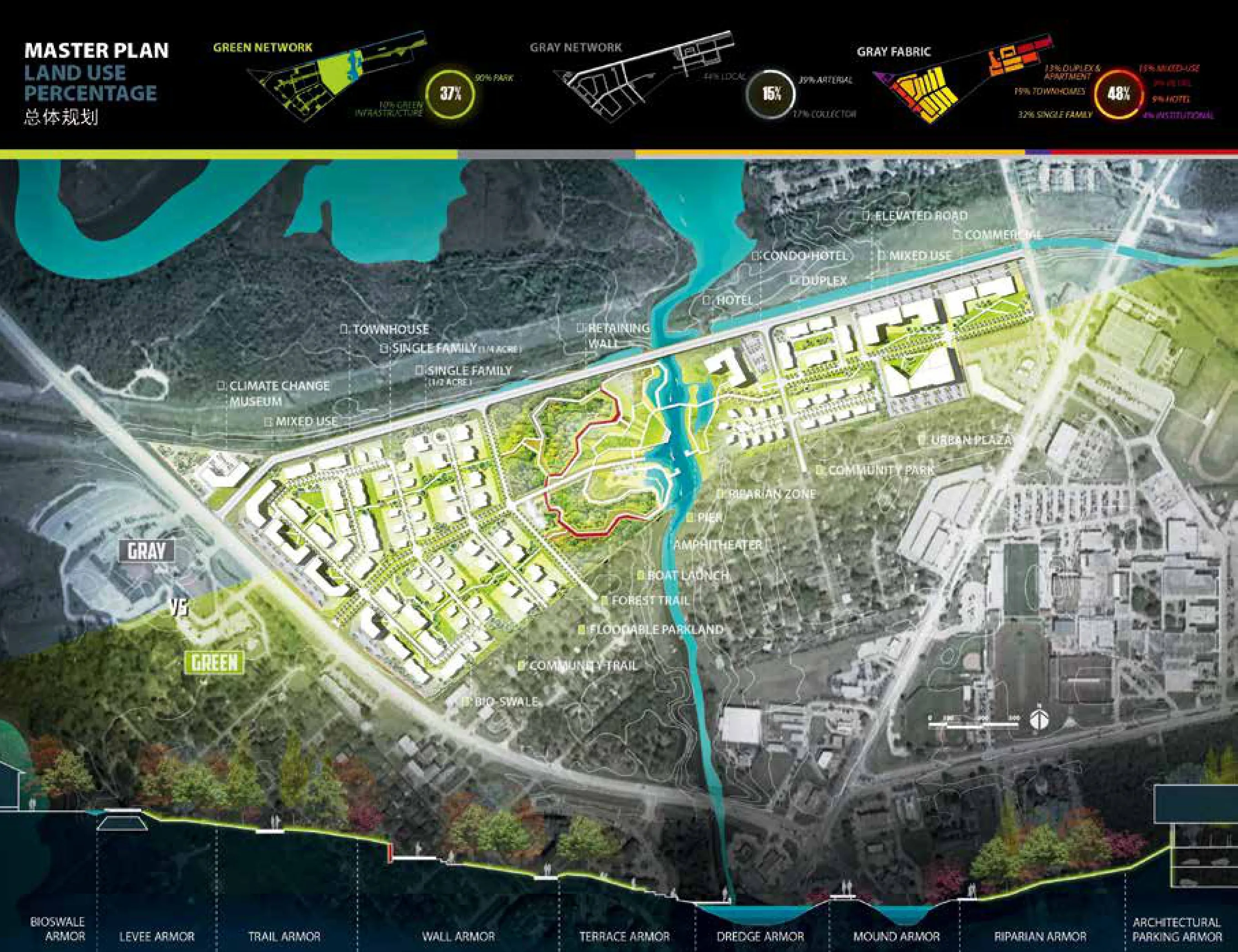
图8 / Figure 8总体规划 / Master Plan
· Dredged Armor—excavated sediment in strategic locations to store flood water which is reused to increase the elevation offuture development;
· Bio-swale Armor—streetscape and urban plaza amenities which convey floodwaters to storage areas and allow for infiltration and filtration of stormwater.
The Climate Change Armor Toolkit's mechanisms are applied throughout the site, and together compose a solid armor to defend the site from current and future flood issues while simultaneously providing recreational, housing and economic opportunities. The designed green space bordering Clear Creek both protects the community from floods and surge and is designed as a park with an amphitheater, recreational pier, riparian edge, hotel and other cultural amenities. It is connected to the designed green infrastructure system through strategically placed bio-swales, elevated trails and eco-levees; engineered based residential areas, commercial space, and transportation lines also act as multifunctional protective structures to help decrease flood vulnerability.
The design is to be implemented in three phases:
Phase (1) Retreat from flood—focuses on placing development in areas with higher elevation area and integrating green infrastructure. The designed medium density commer-cial and mixed-use spaces are connected with existing arterials integrated into the surrounding residence but are strategically placed outside offlood prone areas to limit vulnerability. Public urban spaces with landscape features and permeable paving provide connections to neighbors and promote infiltration, retention, biological treatment, and evapotranspiration processes.
Phase (2) Mitigate flood—develops lower density residences and green infrastructure to provide protection during frequent storms to and gray infrastructure to mitigate larger flood events. Diverse housing types bring in residents from different age groups and backgrounds. New institutional land uses such as a climate change museum provide engaging and educational opportunities for communities.
Phase (3) Control flood—completes major installation of structural and gray infrastructure to create a multi-funtional armor system that block and control heavy floods and regulate hydrologic activity during extreme hazard events. Simultaneously, an interconnected circulation system including pedestrian trails,boat launch points, pedestrian bridges, and bicycle paths enhance local connection to the waterfront, attract tourists, an d create economic opportunities.
4 Design Impact
The structural and non-structural armor typol-ogies are strategically applied throughout the site into the green and gray network/fabric, to protect residents and deliver valuable both ecological and economic benefits. The National Green Values™ Calculator was used to assess the performance, costs, and benefits of the green infrastructure utilized within the design. Compared with conventional approaches, the Green Stormwater BMP(s)of the design decrease the site impermeable area by 26% and capture 30.3% of the runoff volume required. Simultaneously, the design can capture 221,921 ft3 of runoff, creating$419,901 annual green benefits by reducing air pollutants and energy use, providing pollution treatment, increasing carbon dioxide sequestration, escalating the compensatory value of trees, and improving groundwater replenishment (the economic benefits of these benefits by 2100 reaches $13,305,657).
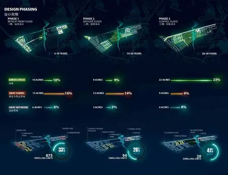
图10 / Figure 10设计周期 / Design Phas
The Climate Change Armor facilities not only create economic and ecological benefits, but also create enormous cultural and social benefits. With its application, the design decreases the 100 year flood plain by year 2100 with sea level rise from 74 acres to 15 acres (from 76% coverage to only 16%). Also, the nearly 2,400 new residents are protected, over 3,000 jobs are created, around $23 million in physical damage is avoided, and nearly $1.3 billion are generated by the life cycle benefits by 2100.
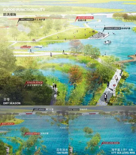
图11 / Figure 11防洪措施 / Flood Functionality
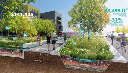
图12 / Figure 12一期:远离洪水 / Phase 1—Retreat from flood
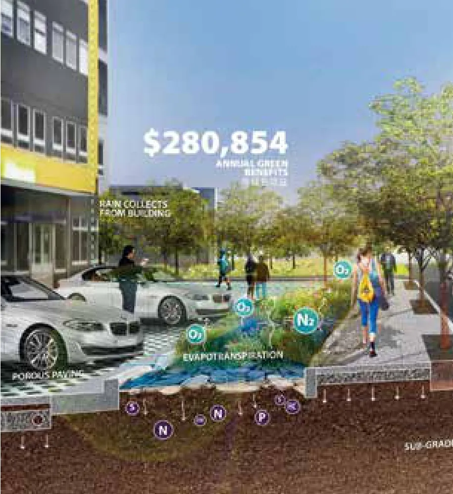
图13 / Figure 13二期:缓解洪水 / Phase 2—Mitigate flood
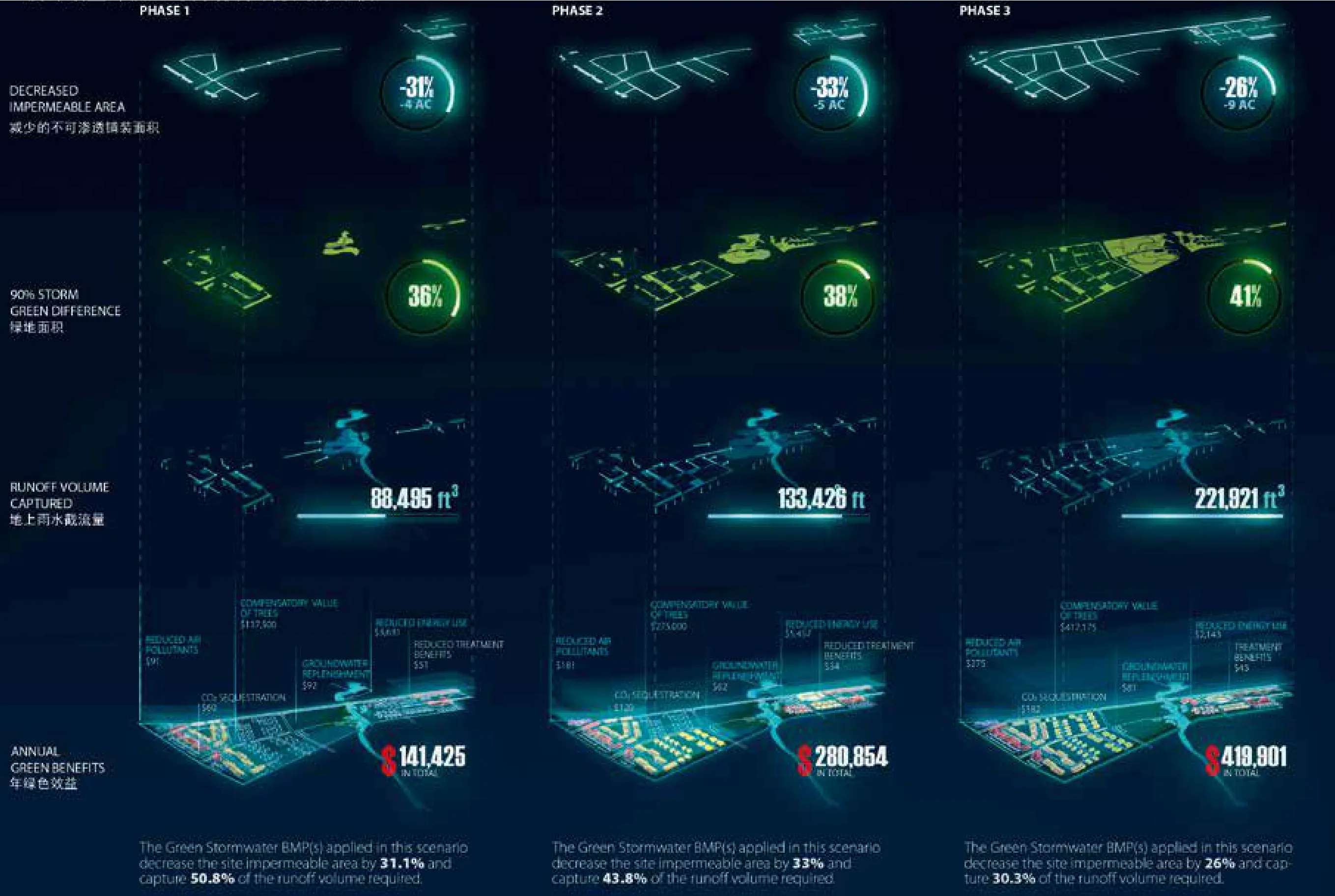
图15 / Figure 15设计效益评估(与传统设计方法的比较) / Design Impact conventional to green
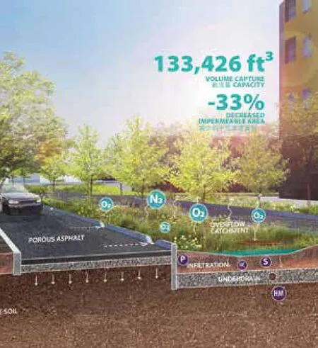
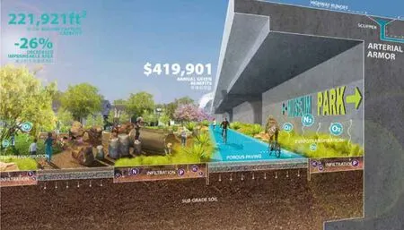
图14 / Figure 14三期:控制洪水 / Phase 3—Control flood
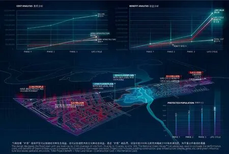
图16 / Figure 16设计效益评估 / Design Impact
猜你喜欢
环球时报(2022-09-26)2022-09-26
护理研究(2021年4期)2021-01-06
江苏安全生产(2020年8期)2020-10-27
中国计算机报(2018年29期)2018-11-01
学苑创造·A版(2017年5期)2017-05-09
科技视界(2016年21期)2016-10-17
河北环境工程学院学报(2016年2期)2016-03-15
少儿科学周刊·儿童版(2015年5期)2015-08-17
少儿科学周刊·儿童版(2015年5期)2015-08-17
党的生活·党员电教与远程教育(2015年2期)2015-04-08
