
Regional gravity survey and application in oil and gas exploration in China
2019-01-13 11:57MinghuZhngJihuQioGengxinZhoXueyiLn
China Geology 2019年3期
Ming-hu Zhng, Ji-hu Qio, Geng-xin Zho, Xue-yi Ln
a Development and Research Center, China Geological Survey, Ministry of Natural Resources, Beijing 100037, China
b Tianjin Center, China Geological Survey, Ministry of Natural Resources, Tianjin 300170, China
c Anhui Academy of Geoexploration, Hefei 230031, China
Keywords:
Concealed and deep-seated structures
Oil and gas basins
Gravity survey
Data integration
Deep oil and gas exploration engineering
China
A B S T R A C T
Ground gravity survey for regional structure unit delineation and oil and gas exploration in China is addressed in this paper with examples.Gravity survey scales, coverage, technical regulations and achievements at the national level are introduced, including data processing and anomaly interpretation techniques.Bouguer anomalies of terrestrial territories of China and classification of anomalous feature zones are also described; they are well correlated with lithotectonical boundaries, fault zones, and unexposed igneous plutons.Recent study results of petroliferous sedimentary basins are presented as well,including concealed boundaries and major structures of large basins.It is concluded that gravity survey is the most effective and economic method in unveiling unexposed and deep-seated structures, targeting and delineating oil and gas-bearing sedimentary basins, and locating main trap structures within prolific basins in early stage of exploration in China.Suggestions for improving exploration of both conventional and unconventional oil and gas reservoirs in China are also given in the paper.
1.Introduction
Among many methods applied in survey and exploration for petroleum resources, geophysical methods are the most effective and successful ones with respect to targeting prolific basins and delineating boundaries of concealed and partially concealed basins and main structures within the basins in early stage of exploration.Gravity survey is one of the most powerful geophysical survey methods.China has started gravity survey and used the survey data in exploration for oil and gas since early 1950’s.Successful examples include discoveries of Changyuan uplift in Daqing oil field in 1958(Fig.1), the buried petroliferous carbonate reefs in Bohai Bay oil field in 1980’s (Fig.2) and the prolific depressions of Jungar oil field in early 1990’s (Fig.3), as well as some new breakthroughs made in recent years.

Fig.1.Gravity anomalies of Changyuan Uplift of Daqing oil field in Heilongjiang Province.

Fig.2.Buried structures of Baohai Bay oil field (faults after Teng CY et al., 2014).

Fig.3.Buried depressions of Junggar Basin and its west thrust fault boundary.
Changyuan uplift was first delineated by 1:1000000 ground gravity survey in 1958 in Songliao Basin.Drilling was deployed at local high points of Gaotaizi and Dapingtun etc.after following electric sounding and seismic exploration around the uplift, and the discovery of Daqing oil field was then made (Xia GZ et al., 2004).The concealed uplift and depression structures and buried petroliferous carbonate reefs in Jizhong, Huanghua and Jiyang depressions was delineated by 1:50000 and 1:100000 gravity anomaly in early 1980s which marked the breakthrough of Bohai Bay oil field exploration (Suo XD et al., 2005; Zhang MH et al., 2018).Drilling results shows that oil bearing structures are correlated well with these uplifts and carbonate reefs, which indicated clearly by local gravity high anomalies (Zhao ZZ et al., 2005).In early 1990s, 1:200000 gravity anomaly revealed there exist concealed late Paleozoic and Mesozoic depressions and uplifts on top of the Precambrian bottom of Jungar Basin and the basin is surrounding with nappe structures as boundary(Ma ZJ et al., 2008; Sui FG et al., 2015; Sun SD et al., 2016;Zhang M et al, 2018).
2.Gravity survey in China
Gravity anomaly is caused by non-uniform density distribution of crustal materials, and as such, deep and regional geological structures, sedimentary basin boundaries,oil and gas trap structures, and even metallogenic belts and deposit structures can be identified and delineated with gravity measurement, i.e., gravity survey.
China has conducted nation-wide, intensive gravity survey since 1982, with an aim at nature resource exploration.For example, gravity survey at scale of 1:1000000 was primarily applied in terrestrial territories of China in 2006.The survey was mainly carried out by China Geological Survey and its predecessor, the Ministry of Geology and Mineral Resources,by technically complying with the Regional Gravity Survey Standard DZ/T0082-1993/2006 (Zhang MH et al., 2011; Sun WK et al., 2017).The gravity survey at a medium scale of 1:250000 which covered 6550000 km2of mostly eastern and some northwestern terrestrial territories of China, was conducted till 2016.The survey included 15 provinces in eastern China with 90% coverage, 5 provinces in central China with 85% coverage, and 10 provinces in western China with less than 60% coverage (less than 30% coverage in provinces of Gansu, Qinghai, Sichuan, and Xinjiang, and in Chongqing; and less than 20% coverage in Tibet).Gravity surveys at scales of 1:100000 and 1:50000 have covered less than 2000000 km2.More surveys at these scales in recent years have been implemented mostly in important petroleumprolific basins and mineral prospecting areas.Fig.4 shows gravity survey coverage in China (till 2016).Resolution of gravity survey at scales from 1:1000000 to 1:250000 or 1:200000 is at the resolution level of 1 mGal (10-5m/s2) in most regions since 2000.The resolution used to be at the level of 2 mGals.

Fig.4.Gravity survey index map of China (till 2016).
Gravity survey at medium scale of 1:250000 is very important for strategic regional targeting and prospecting of minerals and oil and gas resources due to its capability of revealing regional and concealed structures and guiding advanced explorations.However, it has not achieved the goal of 100% coverage of the country.Much work remains to be done for even larger scale gravity survey.
The gravity surveys apply China gravity basic network 1985, Beijing geodetic coordinate system 1954 and Yellow Sea vertical datum 1985.Total resolution of gravity data is about 2 mGals before year 2000 and 1 mGal after year 2000.With a combination of satellite altimetry gravity data and shipboard gravimetric data, total accuracy in offshore areas reaches a wave length of 8 km, which is roughly 3mGal data resolution (Zhang MH et al., 2005, 2007; Fairhead JD et al.,2002; Liu GD et al., 1992, 2018).
Gravity survey has played an important role in many fields of geoscience ever since it has been conducted, such as in tectonic study, delineations of terrane boundaries,concealed faults and unexposed igneous belts, exploration for petroleum and mineral resources, geodetic study, and even in military applications (Xia GZ et al., 2004; Sun WK et al.,2001).
While in gravity anomaly interpretation, data processing and map compilation for regional geological and structural study, grid spacing for national or regional dataset is often set from 10 km×10 km, 5 km×5 km to 2 km×2 km at a scale from 1:1,000,000 to 1:250,000, respectively.Gravity data source used for mineral and petroleum exploration is set at a scale of 1:250,000 and 1:50,000, and its grid spacing is commonly set at 2 km×2 km, 1 km×1 km and 500 m×500 m.
3.Petroleum basin exploration with gravity survey method in China
Exploration for petroleum resources in China in the past began with integrated study and interpretation of gravity,magnetic, and seismic data in order to discover petroleum prolific basins and delineate their boundaries (Sun WK et al.,2017; Zeng HL, 2008).With increased resolution and accuracy of gravity survey, improved data processing technology, and in-depth study of anomalies, identification and characterization of Bouguer anomalies, isostatic residual anomalies, and local residual anomalies become critical in determination, tracking, and delineation of regional and local prolific structures and trap structures within potential basins(Zhang MH et al., 2013, 2015a, 2017; Liu L et al., 2018; Qu NN et al., 2018).Characterization of total horizontal gradient anomalies and determination of basement depth help locate concealed faults and unexposed magmatic plutons, and evaluate volume of source rock sediments (Zhang MH et al.2017; Feng et al.2018).
3.1.Subdivision of gravity anomalies and structural characteristics of sedimentary basins of China
Bouguer anomaly in China generally increases from west to east.For example, the anomaly is below -500 mGal in the hinterland of Tibetan Plateau in the west, but gradually increases up to above 0 mGal along the east coast, with the maximum gradient located along Longmen Mountains of Sichuan Province where it is 1.1 mGal/km.China can be subdivided into four giant, first-order domains based on gravity anomalies, they are Tibetan Plateau, the Northwest domain, the Loess Plateau-Yungui Plateau-Mongolia Plateau Belt, and the East Coast Blocks (Zhang MH et al., 2017).Based on anomaly gradient and regional variation in gravity,there exist nine magnificent gravity-gradient belts and thirteen deep fault zones.The gravity-gradient belts include Greater Khingan Mountains-Taihang Mountains-Wuling Mountains Belt, Helan Mountains-Longmen Mountains Belt, Kunlun Mountains- Qilian Mountains-Qinling-Dabie Mountains Belt,Arkin-Dunhuang-Gansu Corridor Belt, Tianshan-Yinshan-Xilamolun Belt, Bangonghu-Nujiang Belt, South Tibetan Plateau Margin Belt, Qinzhou-Hangzhou Belt, and Tanlu-Yishu Belt (Fig.5).The deep fault zones are associated with major tectonic subdivisions.Generally, areas between the magnificent gravity-gradient belts are underlain by large-size sedimentary basins.Differences and changes in anomaly characteristics between different basins are reflection of variation in crustal thickness, basement properties and depth,and stratigraphic framework and structures of overlying cover strata.

Fig.5.Map showing Bouguer anomalies and feature zone subdivisions of China.
As shown in Fig.5, the gravity subdivisions are correspondent to major lithotectonic units.Based on the gravity gradient belts and variations in anomaly amplitude and shape, China can be further subdivided into 19 first-order anomaly blocks, 73 second-order anomaly blocks, and 91 third-order anomaly blocks (Zhang MH et al., 2017).A large number of the first-order anomaly blocks are underlain by single giant sedimentary basins or groups of sedimentary basins, such as the blocks of Tarim, Alashan, Songliao,Jiamusi, Ordos, Hebei-Shandong-Henan-Anhui, Yunnan-Guizhou-Sichuan, Lower Yangtze, Tibet Plateau, and Sanjiang (or Three Rivers).Majority of the second-order anomaly blocks are elongated orogenic belts, such as the Altay, Tianshan, Xilamulun, Xilinhot, Hailar, Eastern Liaoning-Jilin, Qilian, Kokoxili, Qinling-Dabie, Qinzhou-Hangzhou belts.Among these belts are the scattered Mesozoic-Cenozoic petroliferous basins and depressions.A large number of the third-order anomaly blocks, especially those blocks with gravity lows, are directly correspondent to sedimentary basins and depressions, as well as igneous batholiths.
As shown in Fig.5, major sedimentary basins in eastern China show significantly different gravity characteristics from the major sedimentary basins in central-western China, and in the middle there exists a giant NE-striking anomaly gradient belt along the Greater Khingan Mountains-Taihang Mountains-Wuling Mountains Belt.On the east side of the gradient belt and in eastern China, major basins show low gravity relative to the regional high gravity background.The background Bouguer anomaly values show slight variations.Their isostatic anomalies nearly resemble their Bouguer anomalies.Typical examples include Songliao, Bohai Bay,South Huabei, Subei-South Yellow Sea, Poyang, and Dongting basins.The relatively low Bouguer anomalies in the basins are caused by thick but low-density sediments deposited in the basement depressions.Their background gravity anomaly values are around 0 mGal, indicating that the crust has a thickness at about 30 km.Due to slight variation in the thickness of the crust in the basins, their isostatic anomalies approximate to their Bouguer anomalies.Sedimentary basins in eastern China are predominantly faultblock basins caused by crustal extension and rifting during the Mesozoic and Cenozoic eras.The processes of faulting,rifting, erosion, and deposition took place in the upper level of the crust without making any observable change in Moho depth.
On the west side of the gradient belt and in centralwestern China, major basins are considerably gravity high relative to the regional low gravity background.The background Bouguer anomaly values show drastic variations.Their corresponding isostatic anomalies are low in gravity but show large variations.Examples include the Sichuan, Ordos,Qaidam, and Jungar basins.In central-western China, the major basins were developed as a result of crustal shortening or strike-slip shearing due to plate convergence or intra-plate compression.As such, the crust was generally thickened with the crust underlain basins is only relatively thinner than the surrounding mountains or orogens which are rooted into the crust.The background Bouguer gravity is as low as several hundred negative mGal values due to the 40-70 km thick crust, whereas the basins are gravity high because of their relatively thinner crust.After compensating the mountain root effect in gravity, isostatic residual anomalies show gravity effect caused by considerably thick but low-density sediments in the basins.
3.2.Principles and criteria of geologic interpretation of gravity anomalies of basins
Principles and criteria should be determined and issued prior to conducting geologic interpretation of gravity anomalies in delineating boundaries of concealed basins and depressions, and identifying metamorphic basements, uplifts,and other structural domains and belts.
Basins delineated based on interpretation of gravity anomalies in China are mostly the basins formed during the Mesozoic and Cenozoic and filled with thick, low-density sediments.They are generally characterized by low gravity.Only some of them show high gravity due to uplifted basement (which caused a thicker crust) or because of highdensity sediment fill.Therefore, despite applying the same principles and criteria in interpretation of gravity anomalies,basins may show different types in respect to different characteristics of gravity anomalies due to difference in size and age of basins, variations in thickness and density of sediments, and distinction in properties and structures of their basements.
Principles and methods of gravity anomaly interpretation for basin delineation are summarized in below.The Mesozoic and Cenozoic sedimentary basins are often of gravity low due to relatively low-density clastic sediment fill.Disorderly distributed magnetic anomalies in the basins with gravity low may be caused by volcanoclastic deposits, serving as a criterion for identifying volcanic sedimentary basins.For large-scale composite basins, because they started with sedimentation during their early stage of basin development and then were superimposed by subsequent widespread depression and deposition, their gravity anomalies are characterized by combination of alternating lows and highs of gravity within a generally low-gravity background of the basins.For intermontane basins or block basins, their Bouguer anomalies are largely controlled by the properties and structures of their basements and they generally show secondary anomalies of gravity lows.Their identification and delineation need to be assisted with geological survey.
When delineating basin boundaries, one shall obtain and use residual anomalies separated from the measured gravity anomalies.If using sliding window method to separate anomalies, the size of the window is determined depending on size of a basin.One may test it with different radius and compare the results before selecting the best size.With geological information available for reference, the following quantitative methods can be applied for basin delineation(Zhang MH et al., 2017, 2010; Verduzco B et al., 2004):(1) Using zero-value contour of the residual gravity anomalies; (2) Using zero-value contour of the first-order vertical derivative of the gravity anomalies; (3) Using position of the maximum first-order horizontal derivative or the maximum position of the total horizontal gradient of the gravity anomalies; and (4) Using boundary lines of adjacent gravity anomaly blocks with reference to magnetic anomaly subdivisions.
Interpretation of basin gravity anomalies commonly includes three aspects.The first is the surface shape of basins and their boundaries determined by using Bouguer (residual)gravity anomalies.The second is the configuration, depth, and depth variation of basement through inversion method.The third is the resource potential of a basin assessed through analyses of basin stratigraphy and geological setting.For the second aspect, while performing gravity inversion method to determine basin depth, it is assumed that there exists measurable density contrast between the basement (or a target layer) and the overlying basin fill.It applies algorithms programmed by using either 2.5D cross-sectional forward and inversion modelling or 3D boundary inversion.The result is generally tested with joint gravity and magnetic inversion and interpretation (Sun WK et al., 2017; Zhang MH et al., 2011,2013; Zhang S et al., 2018).Determination of properties and structures of the basement is generally achieved based on characteristics of gravity and magnetic anomalies and available geological information.Availability of other geophysical data such as seismic and electric data, drill core data, and rock property data can help produce a better result.
Basins delineated based on interpretation of gravity anomalies include the following types (Li GY et al., 2002;Zhang et al., 2017): Non-volcanic sedimentary basins or volcanic sedimentary basins with either non-volcaniclastic fill or volcaniclastic fill; Inherited sedimentary basins or superimposed sedimentary basins with a difference in stratigraphic sequence; Fault-block basins or fault basins (also called graben basins) occurring mostly in eastern China due to intracontinental rifting during the Mesozoic-Cenozoic eras;Rifted microplate basins, continental marginal basins, and intermontane basins according to their tectonic positions; and complex basins that have been formed as temporal or spatial superimposition of multiple basins of different types.
3.3.Distribution of petroliferous sediment basins determined by gravity in China
Gravity anomaly interpretation for oil and gas exploration in China has been performed in 8 regions, including Xinjiang,Gansu-Hexi Corridor, Tibetan Plateau-Sanjiang (Three Rivers), Northeast China, North China, South China, Yangtze,and East China Sea.A total of 866 large petroliferous basins and intermontane depressions have been identified and delineated (Fig.6); most of them are aged Mesozoic or Cenozoic (Zhang MH et al., 2018).Examples include Erlian,Hailar, Genhe-Mohe, Bohai Bay, southern North China,Jianghan, Buerjin-Tacheng, Yining, Dunhuang, Sulehe,Maduo, Yushu, and Aba basins and intermontane depressions.Their boundaries are clearly delineated based on gravity anomaly data.Depths to major density-contrast boundaries, in particular, depths to basements, have been obtained through gravity forward and inversion methods for a number of large basins and groups of large basins such as Jungar, Tarim,Qaidam, Qiangtang, Ordos, and Yingen-Ejinaqi basins.Basement configuration, properties, and structures of some large basins such as the Ordos, Songliao, Erlian, and Subei -South Yellow Sea basins, have been determined, also through gravity anomaly forward and inverse modeling and interpretation.
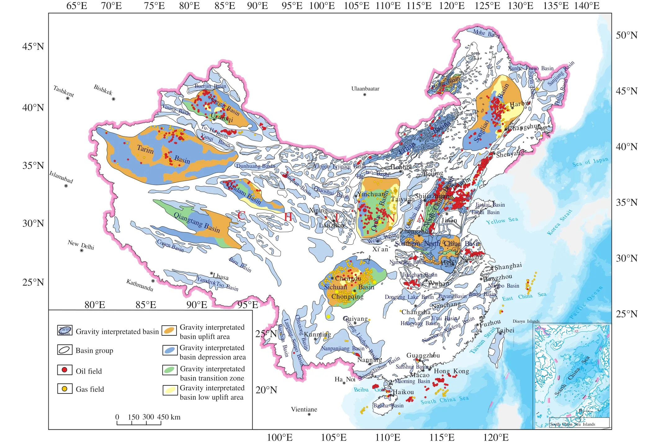
Fig.6.Sedimentary basins and major structures in China based on gravity data interpretation (modified from Zhang MH et al., 2018).
While the basins mentioned above are known basins proven and confirmed through the gravity survey, there are 8 relatively large basins and more than 10 small intermontane depressions identified and delineated for the first time from this nation-wide gravity interpretation.Examples include Fuyun Late Paleozoic basin in northern Xinjiang,Cuokanbaer, Qingshuiquan, and Dulan Mesozoic-Cenozoic basins in northern Tibetan Plateau, Wulanhot - Tuquan Late Paleozoic basin in western Greater Khingan Mountains of Northeast China, Guiyang-Liuzhou Late Paleozoic basin in lower Yangtze Block, and Linhai, Sixi, and Wencheng Mesozoic-Cenozoic basins in South China.The total surface area of the newly-identified and delineated basins and depressions is 110000 km2.Concealed boundaries of some known basins have been delineated based on the new gravity survey data at much higher precision, which involves a total surface area of 310000 km2.Examples include Biru basin and Cuoqin basins in Tibetan Plateau, Tarim basin in Xinjiang,several basins in southern Qilian Mountains in Gansu-Hexi Corridor, southern North China basin in North China, and some small basins in South China.
In general, the nation-wide gravity survey and data interpretation have helped improve our understanding of regional sedimentary basin types, regional structure framework, and geology at conjunction areas among China’s three major continental blocks (the Tarim, North China, and Yangtze blocks) and five major orogenic mountain belts (the Tianshan-Xingmeng, Qinling-Qilian-Kunlun, Qiangtang-Sanjiang (Three Rivers), Gangdise-Himalaya, Wuyi-Yunkai orogenic mountains belts) (Zhang MH et al., 2017).The gravity survey and data interpretation have also resulted in identification and localization of 13 first-order, 311 secondorder, and 3133 third-order fault belts, as well as a total of 2384 unexposed and partially exposed igneous plutons in China.
4.Suggestions
It is clear from the above that gravity survey has played an important and unique role in oil and gas exploration in China.Yet, comprehensive exploration for oil and gas using gravity anomalies to discover large petroliferous basins, has not been fully implemented in China, in particular in western China and in Chinese continent shelf areas where fundamental geophysical survey and integrated research are generally behind other areas in terms of coverage and survey scales(Zhang MH et al., 2015b).Some elongated second-order gravity anomaly zones along lithotectonic and orogenic belts such as the Aertai, Tianshan, Xilamulun, Xilinhaote, Hailaer,East Liaoning - East Jilin, Qilian, Kekexili, Qinling - Dabie,and Qinzhou - Hangzhou belts, contain numerous Mesozoic-Cenozoic petroliferous intermontane basins and depressions.However, the 1:50000 scale gravity survey has not yet been performed in these areas.
It is suggested that the gravity survey at a scale of 1:250000 and larger should be implemented in the entire western China where only 1:1000000 scale surveys have been performed.In eastern China, the 1:50000 scale gravity survey should be fully carried out in areas with known basins and their marginal areas with focus on recently targeted areas and the basins with recently-discovered proliferous rock layers.Meanwhile, comprehensive geological survey with integration of multiple disciplines should be carried out to include unconventional energy resources such as shale gas and gashydrates.For an efficient and effective exploration, it is important to integrate gravity, magnetic, electric, and seismic data, perform comprehensive 3D modeling and interpretation,and utilize available technologies and techniques of computing and analysis.
5.Conclusions
Regional gravity survey has played an important role in exploration for petroleum and mineral resources and in tectonic and geological research in China.It has become a critical and effective geophysical technology in exploration for conventional oil and gas, and in particular for unconventional oil and gas in recent years (Moore D et al.,2013; GIM International, 2016; Zhao WJ et al., 2012;Zhang MH et al., 2007).Significant achievements made through nation-wide gravity survey and gravity anomaly interpretation are summarized below:
(i) Gravity anomalies show step-wise change (with four steps) from western China to the east coast and thinning in crustal depth from 75 km to 20 km.
(ii) Gravity survey plays unique role in helping target petroliferous basins and inner basin structures patterns during early stage of exploration, especially for buried basin boundary delineation, concealed depression, uplift and carbonate reef reveals, and depths to the basement estimation as well.
(iii) Gravity survey also helps visually reveal shape,depth, and spatial distribution of igneous plutons with 3D inversion and modeling methods (Zhang MH et al., 2017; Liu L et al., 2018).It also effectively assists locating regional large fault zones.
(iv) Gravity survey technology, anomaly interpretation,and data processing techniques are much improved in China in recent years.They meet needs for practically high precision and accuracy.Meanwhile, a large number of geophysicists working for national, regional, and provincial surveys and companies have been trained through practice and become leaders in the field.China is among the leading countries in the world in gravity data collection, intergradation,processing, standardization, management, and applications.
(v) China has a vast territory and a large number of petroliferous basins.Fundamental exploration work needs to be performed in the areas with unconventional resource potential which includes shale gas, offshore and terrestrial high-altitude gas-hydrates, and in intermontane depressions of vast regions in the west.Geophysical survey is especially needed to decipher deep levels of basins and in particular in the areas without any bedrock exposed.Application of gravity and magnetic surveys in these areas can be fast and economic while also effective and productive during early stage of exploration.
Acknowledgement
This project is financially supported by China Geological Survey “National Mineral Resource Assessment Program ”(1212010633904, 1212010733805, and 212011121039) under supervision and instruction of Tian-zu Ye, Wen-ke Sun, Shiyi Liu, and Shou-min Lei.The authors thank Jie Dong, Kuanhou Liu, Zhong-ren Sun, Chun-fang Zeng, Mei-xia Su, Yin-ye Wu, Zhen-xuan Guo, Ling Liu, Xi-min Zhu and professor Chun-zeng Wang for their contributions to the project and to this paper.
- China Geology的其它文章
- A mine drainage treatment system for AMD in remediation of metal sulfide mines
- Stromatolite characteristics of Mesoproterozoic Shennongjia Group in the northern margin of Yangtze Block, China
- Zircon U-Pb ages of the two-periods magmatism from the Xiuwacu Mo-W-Cu deposit,northwest Yunnan, China
- New zircon U-Pb ages of the Xinghuadukou Group, Xing’an block and its geological implications
- Promoting high-level cooperation in geosciences and assisting high-quality development of mining: “Belt and Road” Forum for International Geoscience Cooperation and Mining Investment was held in Xi’an, China
- Deepest deep-hole integrated geophysical observation system has successfully installed