县域尺度农田深层土壤有机质的估算及空间变异特征
2019-02-21 04:10王国芳张吴平毕如田申若禹王佩浩
农业工程学报 2019年22期
王国芳,张吴平,毕如田,张 茜,任 健,乔 磊,申若禹,王佩浩
县域尺度农田深层土壤有机质的估算及空间变异特征
王国芳1,张吴平2※,毕如田1,张茜1,任健1,乔磊1,申若禹1,王佩浩1
(1. 山西农业大学资源环境学院,太谷 030801;2. 山西农业大学软件学院,太谷 030801)
县域是实施农业绿色发展的基本单元,农田土壤中不仅耕层的有机质含量会对土壤肥力产生影响,深层有机质的作用也不可忽略,精确估算基于县域尺度农田深层有机质含量具有重要意义。该研究选定位于山西省运城市的永济市农田为研究区,采用多点混合取样法,获取了8个样地剖面的18层数据,共144个混合土样的有机质含量数据,建立了表层(0~20 cm)有机质含量估算深层有机质含量的模型,并进行深层有机质含量的估算。基于半变异函数、空间自相关理论分析了0~30、>30~60、>60~90、>90~120、>120~150和>150~180 cm土层有机质含量的空间相关性和聚集特征,并进行了相关性检验,采用克里格插值方法对研究区农田各土层的有机质含量进行了预测。结果表明:1)土壤有机质含量随深度的增加呈负指数递减(2=0.80,<0.01),各土层的有机质含量变异系数介于35.89%~47.84%之间,处于中等变异程度。2)通过建立的估算模型可以通过表层有机质含量估算出任意深度的有机质含量,且拟合精度2达到了0.90(<0.01)。3)指数模型是反映该区域有机质含量空间结构特征的最佳模型(2>0.80,RSS<0.001),各土层的有机质含量均表现出了中等程度结构性特征,和空间正相关性特征(Moran’s=0.26,<0.01),并存在显著的空间聚集特征和异常值现象。4)克里格插值可以较好地进行研究区各层有机质含量的预测,预测精度较高,稳定性较好,为县域尺度深层有机质的估算,调整农艺措施、提高土壤肥力、达到土壤减肥增效、绿色增产增效提供依据。
土壤;有机质;反演;县域尺度;农田;空间变异;克里格插值
0 引 言
土壤有机质作为土壤的重要组成部分在改善土壤结构、增强土壤肥力、增产增效、促进农业可持续发展等方面都具有非常重要的意义[1-3]。一般农田耕层中有机质含量较少,耕层以下更少,但它的作用却很大,对于提高作物养分水分的吸收利用效率、促进植物对营养元素的吸收,刺激根系的生长等有着重要的作用[4-6]。为此,分析土壤耕层和深层有机质含量的空间分布规律对于探讨农业耕作措施、实现“减肥减施、增产增效”及指导土壤管理具有重要意义。
目前,对于土壤表层有机质含量的估算方法已臻成熟,包括借助地统计理论等数学模型的地表实测方法[7-9];包括借助遥感技术的直接估算法[10-11]、间接测定法[12-14]、高光谱测定法[15-17]等大面积快速获取的遥感方法,但目前遥感反演土壤有机质以表层效果较好[18-19],深层的快速大面积估算较困难。已有研究表明,土壤深层有机质含量与表层有机质含量呈极显著相关关系[20-22],为此,可以通过表层的有机质含量估算深层有机质含量,已有的研究主要通过经验法和线性回归法进行估算[23-24],本研究将通过研究农田实测数据的深层有机质含量与表层有机质含量的关系,建立表层有机质含量估算任意深度有机质含量的模型,从而定量分析不同土层土壤有机碳的空间特征。
已有研究表明,借助地统计模型的半变异函数参数变程、块基比可以定量反映有机质含量的空间变异性特征和结构性特征[25-27];借助空间自相关分析方法的全局莫兰指数和局部莫兰指数可以反映采样点的空间自相关程度和空间聚集程度[28-30];借助克里格插值可以获取整个研究区的有机质含量[31-34]。在实施农业绿色发展的空间尺度中由于县域具有规模适中、边界清晰、易操作、可评估复制,且具有示范效应等的特点,为此以县域作为基本单元。以往研究多基于县域尺度进行土壤表层有机质的空间尺度效应及空间变异特征分析[35-37],基于县域尺度下的农田土壤不同土层的有机质含量空间变异特征和聚集特征有待研究。
为此,本研究选取了地形复杂的山西省运城市永济市的农田为研究区域,通过分析0~180 cm剖面中每10 cm为一层,共18层的土壤有机质含量值关系特征,建立了表层(0~20 cm)有机质含量估算任意深度有机质含量的估算模型,利用建立的估算模型,对分布在研究区的3 519个表层(0~20 cm)有机质含量样点数据进行0~30、0~60、0~90、0~120、0~150、0~180 cm深度的有机质含量估算,从而得到0~30、>30~60、>60~90、>90~120、>120~150和>150~180 cm共6层的有机质含量数据,通过半变异函数分析各土层的有机质含量空间变异特征,通过全局莫兰指数和局部莫兰指数分析各土层有机质含量的空间自相关性特征和聚集特征,并进行相关性检验,最后通过克里格插值获取研究区农田的各土层有机质含量,为研究区深层土壤有机质含量的估算及农田土壤肥力评价和优化农业实践措施提供依据。
1 研究区概况
研究区永济市位于华北、西北、中原三大地域连接处的山西省西南端,隶属于山西省运城市,东邻山西省运城市,南依中条山,西临黄河,北接山西省临猗县,地理坐标为110°15′00″~110°45′33″E、34°44′50″~35°04′50″N(图1)。
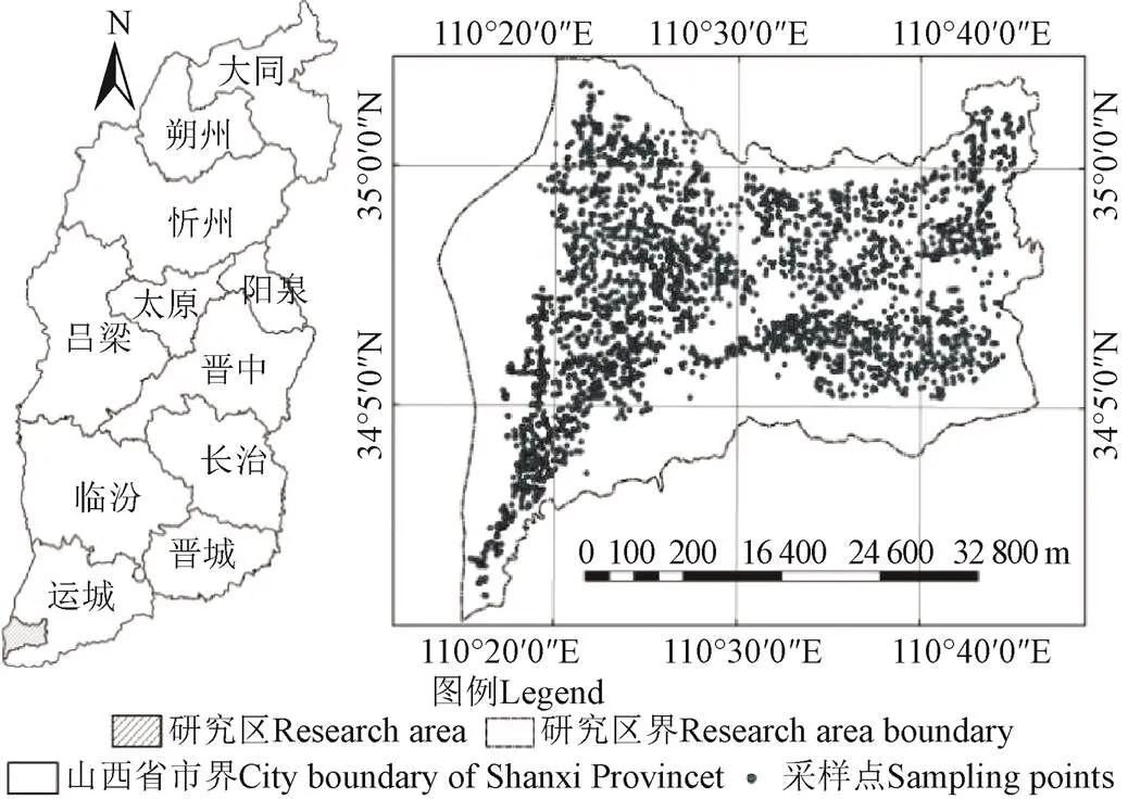
图1 研究区位置和采样点分布图
研究区属温带大陆性气候,年平均气温14.10 ℃,常年平均降水量530 mm。研究区地处山、塬、河的交汇处,地形南高北低,东西狭长,北部为平川,南部为中条山,海拔为334~1 993.9 m,差异较大。土地利用以旱地为主;土壤类型以褐土为主;土壤类型主要包括褐土、棕壤土、潮土、盐土、石质土(图2)。

图2 土壤类型图
Fig.2 Soil category
2 材料与方法
2.1 样品采集与处理
试验地点设在永济市的农田内,在10月份农作物收割之后,小麦种植之前,根据土壤类型确定了8个样地,每个样地3个垂直剖面,每个垂直剖面进行分层取样(10 cm为1层),每层随机取3个样,同层进行土样混合,形成混合样,取到180 cm深度共18层,混合样共计144个。每层土样采用重铬酸钾容量法测定有机质的含量。这些数据用来进行表层反演深层有机质含量的模型建立。
研究区农田的表层(0~20 cm)土壤有机质含量数据采用永济市耕地质量评价的研究成果,共3 519个采样点(图1)。基于山西省土类土壤系统获取了研究区土壤类型(图2),开展县域尺度下的深层土壤有机质含量估算及空间变异特征分析。
2.2 研究方法
2.2.1 深层有机质估算模型及验证
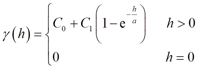
本研究根据表层有机质含量与深层有机质含量的关系,提出了通过表层有机质含量估算深层有机质含量模型。
式中为0~cm的土壤有机质含量,%;0为土壤表层0~0cm的土壤有机质含量,%;为土壤深度,cm;、、、为常数。本研究0取20 cm。采用非线性回归方法确定、、、常数的值,采用相对误差进行模型的验证,相对误差越小越好。
2.2.2 半变异函数
半变异函数是研究土壤属性在空间分布中的结构性、随机性、相关性和依赖性等的主要工具之一[38]。半变异函数通过公式(2)进行估算。
式中(x)和(x+)分别是土壤有机质含量在空间位置x和x+处的观测值;()是分隔距离为时的样本点对数。
本研究采用半变异函数模型的指数模型[39],其计算方法为公式(3)。
块基比(0/(0+1))用来表示由随机部分引起的空间异质性在系统总变异中所占的比例,块基比比值越小,空间相关性越强;块基比小于25%具有空间强相关性、介于25%~75%之间具有中等程度空间相关性、大于75%具有空间弱相关性[40]。
2.2.3 空间自相关分析
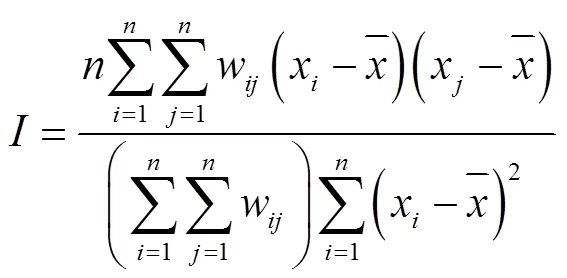
通过全局莫兰指数(Global Moran’s)(公式(4))[41],分析研究区有机质含量空间自相关分布特征。

通过95%为置信区间的检验(公式(5))对研究区有机质含量的空间自相关性分布特征进行显著性检验。
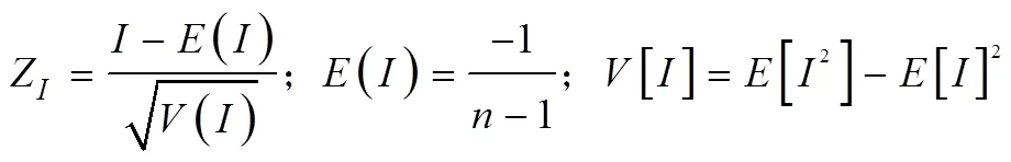
式中Z为统计量得分;为全局莫兰指数;为有机质采样点个数;[]为莫兰指数的期望值;[]为莫兰指数的方差;|Z|>2.58(<0.01)为非常显著相关,|Z|≥1.96(<0.05)为显著相关,|Z|<1.96(>0.05)为不显著相关。
以局部莫兰指数(Local Moran's)在更细粒度范围下对研究区的有机质含量进行聚类和异常值的分析,并在0.05显著性水平下进行显著性检验,具体局部莫兰指数相关理论见参考文献[43]。
2.2.4 基于克里格的空间预测与精度评价
本研究将研究区的3 519个有机质采样点数据通过ArcGIS10.0地统计分析模块的Subset Features子要素集模块按80%为训练样点,20%为验证样点,将样点数据分为两部分。基于训练样点数据,采用GS+软件求得最佳的半变异函数模型参数,并基于ArcGIS10.0克里格插值模块生成各土层有机质含量,并对预测结果采用均方根误差(root mean square error,RMSE)检验空间预测值的稳定性,值越小越稳定;采用平均绝对误差(mean absolute error,MAE)检验模型的精度,值越小精度越高;采用标准化均方根误差(root mean square standardized error,RMSSE)检验模型的拟合精度,值越接近于1,拟合精度越好。各指标的计算方法参考相关参考文献[44]。
3 结果与分析
3.1 土壤有机质的垂直分布变化规律
根据实测结果,绘制了土壤有机质含量在垂直剖面上的分布特征(图3),并基于SPSS软件,获取不同土层的有机质含量统计特征值,并采用单样本-法进行正态分布检验(表1)。土壤有机质含量随深度的增加呈减少趋势(图3、表1)并呈负指数递减变化(2=0.80,<0.01)(图3),且0~60 cm范围内土壤有机质含量的下降速率要大于>60~180 cm有机质含量下降速率。
由表1可知,0~30、>30~60、>60~90、>90~120、>120~150、>150~180 cm各层土壤有机质的质量分数分别为1.54%±0.68%、0.79%±0.30%、0.61%±0.22%、0.51%±0.23%、0.50%±0.24%、0.45%±0.21%,各层土壤有机质含量均值随着深度的增加而减少。各层土壤有机质含量变异系数存在一定的差异,介于35.89%~47.84%之间,平均为43.16%,处于中等变异程度[44],且深层有机质含量的变异程度要高于表层。正态分布检验结果表明,各土层有机质含量数据均符合正态分布(>0.05),不同土层有机质含量的数据具有一定可比性。

图3 土壤有机质含量随土壤深度的变化图
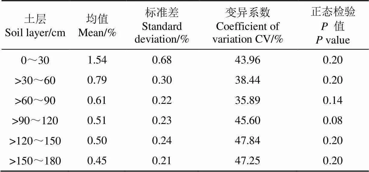
表1 不同土层土壤有机质含量基本统计参数
3.2 表层有机质估算深层有机质模型参数反演
采用公式(1)进行表层有机质含量估算深层有机质含量模型的拟合,拟合得到参数、、、的值分别为0.0421、-0.2869、0.7001、-0.005,从而可以求得任意深度的、值(2=0.90,<0.01)。基于该模型,计算得到剖面数据各层的预测值,通过计算相对误差,得到误差小于16%的占到49.6%,介于16%~40%的占到44.1%,表明该模型能够较好的用来估算深层有机质含量。
3.3 基于半变异函数的有机质含量空间特征分析
基于GS+地统计学软件,分别计算土壤6个不同土层有机质含量的半变异函数及其相关参数,根据拟合决定系数(2)最大与残差和(RSS)最小进行最佳模型的选择。结果表明,各土层的最优模型均为指数模型(2>0.80,RSS<0.001),具体模型参数见表2。
从表2可以看到,各土层的变程大小基本一致,平均为11 240 m,可以看出研究区的农田土壤有机质含量空间自相关范围较大,说明研究区各层有机质含量分布变化性较小。从块金值0和块基比(0/(0+1))分析,可以看出,研究区各土层的块基比介于61.54%~72.45%之间,为中等程度空间相关性,表现为随机因素对有机质含量空间结构变异贡献较大。
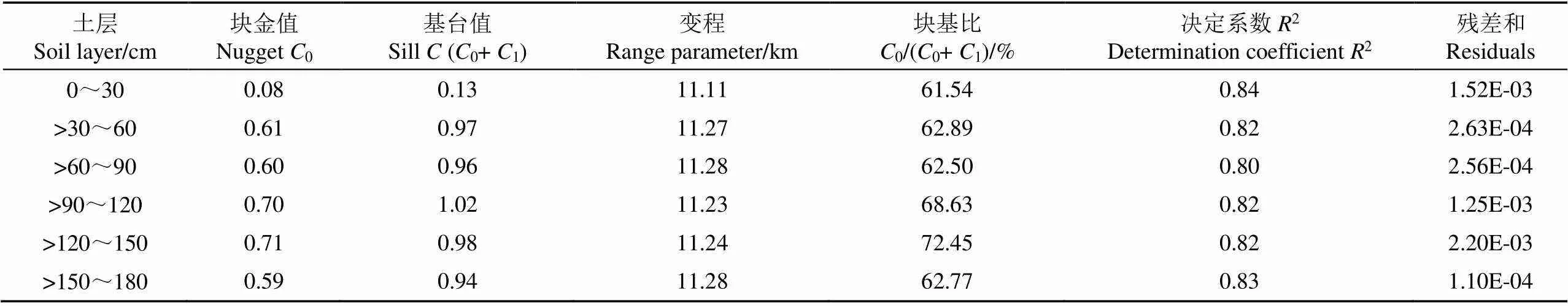
表2 不同土层有机质含量指数函数模型参数特征
3.4 基于空间自相关的有机质含量空间特征分析
基于OpenGeoDa软件和ArcGIS10.0对研究区各土层分别计算有机质含量的全局莫兰指数(Moran’s),通过全局莫兰指数进一步分析研究区各层有机质含量的空间自相关性,结果表明各层的全局莫兰指数具有相似性,各层全局莫兰指数Moran’s均值为0.26,表明该研究区的有机质含量的空间分布呈正相关特征,得分均值为59.21,大于正态分布99%置信区间双侧检验阈值2.58,且空间自相关性通过了0.01 显著性检验,表明研究区农田的有机质含量在空间分布上存在聚集现象。
以0~30 cm土层为例,通过分析间隔距离与全局莫兰指数的关系(图4),可以看出,Moran’s随着间隔距离的增大,出现先减小后增加的趋势,且由正值变为负值,这表明研究区农田的有机质含量在一定间隔距离范围内在空间上出现空间正相关性,但随着间隔距离的增加空间正相关性逐渐消失,直到Moran’s=0表现出有机质含量空间分布呈现随机性,随着间隔距离的继续增加,莫兰指数出现负值,表明研究区农田有机质含量在空间上出现高值与低值相邻的现象,当Moran’s等于0时对应的间隔距离为研究区的空间相关距,为此,本研究区的空间相关距为10 900 m,与通过半变异函数计算的变程为11 110 m有差异,与计算算法各异有关。
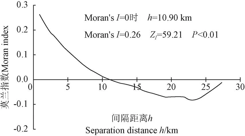
图4 土壤有机质含量莫兰指数图(0~30 cm)
为了能够在更细粒度范围下对有机质含量的空间相关性进行探索,计算了各土层有机质含量的局部莫兰指数,从而分析有机质含量的空间聚集和异常特征。各土层的局部莫兰指数特征基本一致,本文以0~30 cm土层有机质含量的空间聚集特征为例,如图5所示。
从图5可以看出,各土层均出现了有机质含量的高值聚类(High-High)、低值聚类(Low-Low)、低值被高值包围(Low-High)和高值被低值包围(High-Low)的现象。对于高值和低值聚类的样点有机质含量空间差异程度较小,存在较强的空间正相关;在高值被低值包围或低值被高值包围的样点有机质含量空间差异性较大,存在较强的空间负相关,异质性突出,这与图4的结果是一致的。
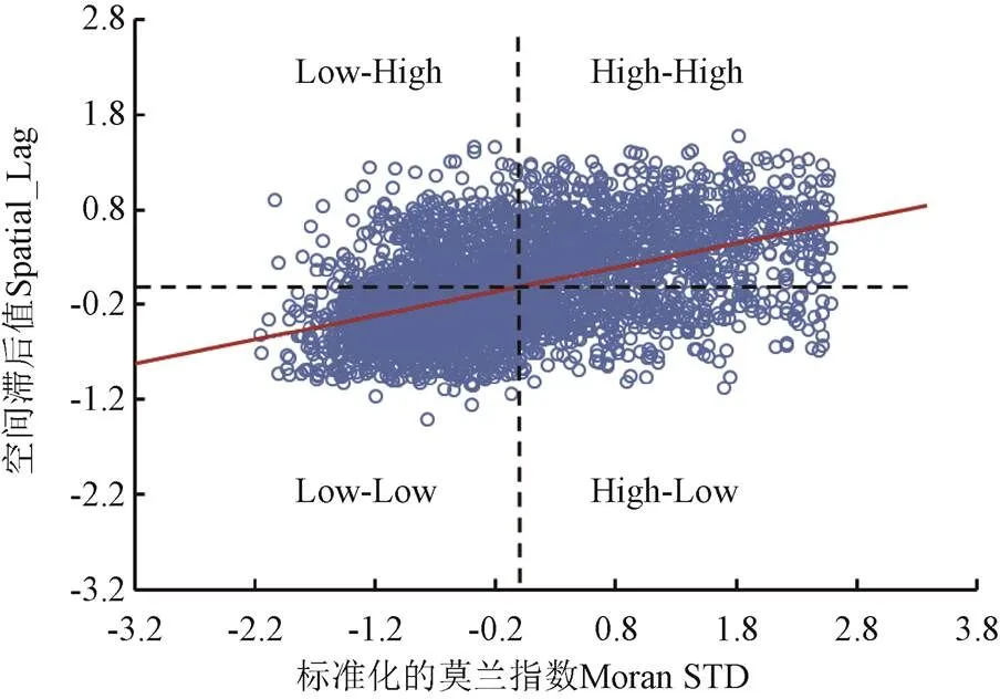
图5 土壤有机质含量空间聚类和异常值分析(0~30 cm)
进一步对各土层样点有机质含量的空间自相关性在95%置信水平下进行显著性检验,各层有机质含量的显著性水平基本类似,且分布特征基本一致。本文给出0~30 cm土层样点有机质含量显著性检验的空间分布特征和各土层的显著性样点数范围,如图6所示。
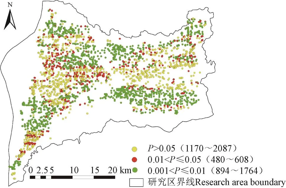
注:图例括号中的数字为各土层显著性样点数量范围。
检验结果表明,不显著的样点个数介于1 170~2 087之间,平均为1 375,占到总样点个数的39.08%;达到95%置信水平但没有达到99%置信水平的样点个数介于480~608,平均为557,占到总样点个数的15.83%;达到99%置信水平但没有达到999%置信水平的样点个数介于894~1 764,平均为1 587,占到总样点个数的45.09%;达到999%显著性水平的样点个数为0。
从图6可以看出,不显著的区域主要分布在研究区的西中部和东北部,显著性检验0.01<≤0.05的区域主要零星分布在北部,占的比例较小,显著性检验0.001<≤0.01的区域主要集中在西南部、东南部、北部大部分区域。
通过局部莫兰指数进一步分析了有机质含量各层空间聚类的空间分布特征,并在95%置信水平下进行检验。各土层的空间聚集特征基本一致。本文给出0~30 cm土层有机质含量的空间聚集分布特征和各土层的聚集特征样点数范围,如图7所示。
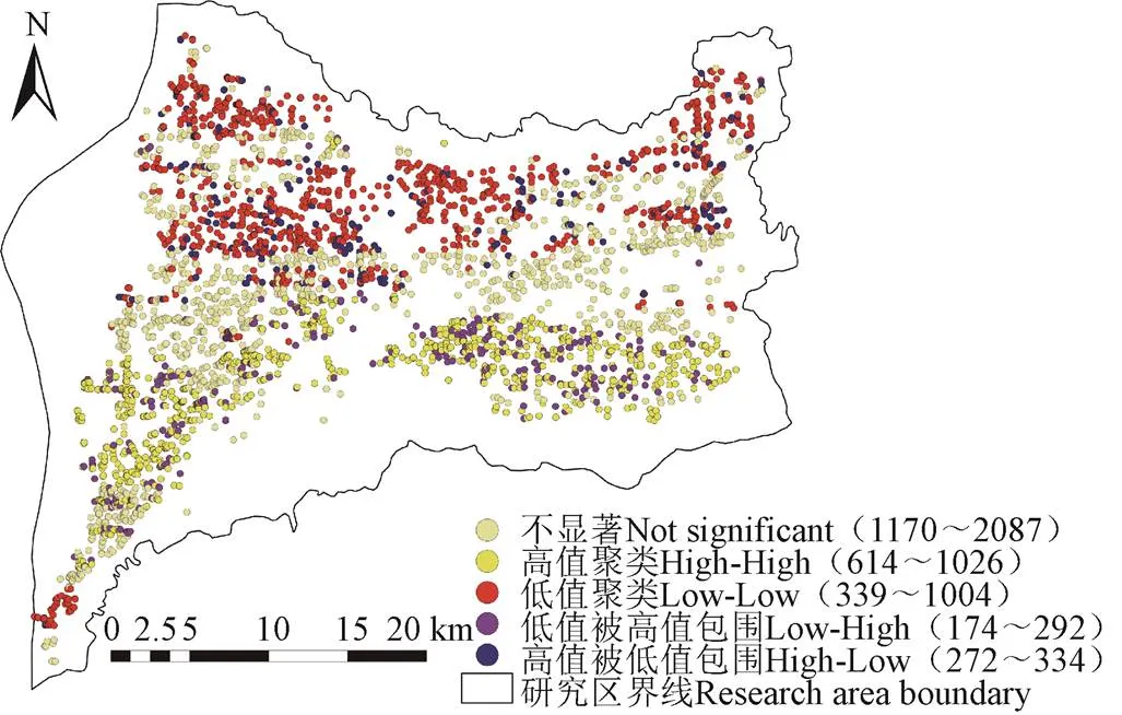
注:图例括号中的数字为各土层的聚集特征样点数量范围。
从图7可以看出,对于不显著表现出聚类特征的样点数介于1 170~2 087之间,平均为1 375,占到总样点个数的39.08%;对于显著表现出High-High特征的样点个数介于614~1 026之间,平均为850,占到总样点个数的24.15%;对于显著表现出Low-Low特征的样点个数介于339~1 004之间,平均为736,占到总样点个数的20.91%;对于显著表现出Low-High特征的样点个数介于174~292之间,平均为252,占到总样点个数的7.16%;对于显著表现出High-Low特征的样点个数介于272~334之间,平均为306,占到总样点个数的8.70%;结果表明,研究区农田土壤有机质含量呈现出空间聚类现象。
3.5 基于克里格插值的有机质含量空间预测
基于上述指数模型,采用克里格插值方法对研究区内农田土壤有机质含量进行空间预测,根据自然断点法将有机质含量分为4个等级,根据插值结果可以看到各土层的有机质含量空间分布特征相似,本文以0~30 cm为例,农田有机质含量空间分布特征如图8所示。从图8可以看到,克里格插值的结果与空间聚类分析的结果保持一致。研究区农田各土层土壤有机质含量在东西方向没有表现出明显的趋势,而在南北方向表现出明显的北低南高趋势。
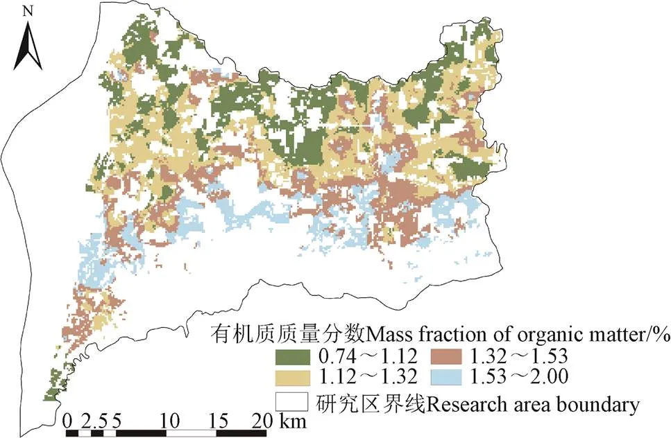
图8 土壤有机质含量空间预测分布图(0~30 cm)
通过对克里格插值的各层有机质含量的分析(表3),可以看到0~30、>30~60、>60~90 cm、>90~120、>120~150、>150~180 cm各层土壤有机质的质量分数分别为1.30%、0.77%、0.61%、0.50%、0.49%、0.43%,且各层土壤有机质含量随着深度的增加呈减少趋势(2=0.93,<0.05),这与实测剖面的分析结果一致。
对各层土壤有机质含量预测结果通过均方根误差(RMSE)、平均绝对误差(MAE)和标准化均方根误差(RMSSE)进行精度分析(表3)。
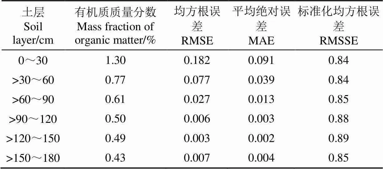
表3 不同土层克里格插值预测有机质含量精度分析
从表3可以看出,从预测结果的稳定性角度分析,0~30、>30~60、>60~90、>90~120、>120~150、>150~180 cm的均方根误差分别为0.182、0.077、0.027、0.006、0.003、0.007,表明该模型对有机质含量的预测稳定性较高,随着土层深度的增加,预测稳定性增加;从模型的精度角度分析,与稳定性结果吻合,各土层的平均绝对误差为0.025,随着土层深度的增加平均绝对误差逐渐减小;从模型的拟合程度角度分析,各土层的标准化均方根误差均达到了0.84以上,表明该模型的拟合程度较好。
4 讨 论
研究结果表明研究区土壤有机质含量随着土壤深度的增加,呈减少趋势,且深层变异程度要大于表层,这与张娜等[24]的研究结果一致。主要原因在于农作物产生的大量枯落物的分解、还田秸秆的分解,主要集中在0~30 cm土层的作物根系分泌物以及蜗牛、蚯蚓等动物的活动等都为0~30 cm土层提供了丰富的有机质。而随着深度的增加,土壤紧实度增加,作物根系分布较少,受外界环境的影响逐渐减少,故有机质含量减少。
本研究在表层有机质含量估算深层有机质含量的模型建立时,仅仅考虑了表层是(0~20 cm)的情况,今后会考虑不同深度表层数据对模型精度的影响。由于实测数据数量较少,加之有机质含量的空间变异性强,为此加大实测数据量和对模型精度的验证有待提高。通过GS+空间变异理论进行半变异函数分析时得到的半变异函数模型拟合程度最高,残差和最小的是指数模型,这与郑然等[45]的研究结果是一致的。通过半变异函数和全局莫兰指数分析,研究区不同土层的有机质含量表现出中等程度的空间正相关性,且随着深度的增加随机性因素占的比例逐渐增大,这与程先富等[46]、张娜等[47]的研究结果一致,通过局部莫兰指数分析,不同土层均表现出空间聚集现象,这与刘丽[48]的研究结果一致。
研究区不同土层的有机质含量呈破碎斑块状分布格局,整体来看,土壤有机质含量主要表现为由北向南逐渐增大的趋势、显著低值聚类区域主要分布于张营镇的大部分区域、开张镇的西部、卿头镇的北部和东南部及韩阳镇的西南部,主要的土地利用类型为旱地;显著高值聚类区域主要分布于永济市城西、蒲州镇大部分区域、虞乡镇南部区域,主要的土地利用类型为水浇地;不显著出现聚类特征主要分布在永济市城东、城北以及开张镇的大部分区域,主要受人类活动的影响。
已有研究表明,有机质含量受气候、地形、土壤类型、土壤水分、植被类型、人类活动等因素的影响[49-50]。在该研究区内由于气温和降水量的差异不是很明显,为此气候因素对有机质含量的空间分布影响较小;研究区内的地形明显表现为北低南高,北部为平川,海拔在350 m左右,由于地势较低,部分地区为盐碱下湿地,该部分区域的有机质含量较低;研究区的耕地类型主要为旱地、水浇地和河滩地3类,水浇地和旱地的有机质含量高于河滩地的有机质含量;研究区农田土壤类型主要有褐土性土、石灰性褐土、典型褐土、潮褐土、潮土、盐土,其中褐土性土和潮土分布的区域有机质含量较高,而在石灰性褐土和典型褐土区域有机质含量相对较低,研究区农田有机质含量受土壤类型的影响,人类活动包括耕作措施也会对有机质含量的分布造成影响,有待进一步定量的分析其影响因素。
本研究在分析空间变异特征时没有从各向异性的角度深入分析,且本研究是基于县域尺度进行,相关研究表明[51-52],区域尺度和采样点数目及密度都会对空间变异结果有所影响,今后在县域范围内考虑不同的乡镇或村尺度,以及采样点的数量、各向异性等方面综合考虑来更进一步分析研究区的有机质含量空间结构特征。
根据农业土壤养分分级标准[53-54]对有机质含量(%)的划分:有机质质量分数>4%为极高,3%<有机质质量分数≤4%为很高,2%<有机质质量分数≤3%为高,1%<有机质质量分数≤2%为中,0.6%<有机质质量分数≤1%为低,有机质质量分数≤0.6%为很低。耕层(0~30 cm)的有机质含量为中等级别,>30~60、>60~90 cm的有机质含量为低等级别,>90~120、>120~150、>150~180 cm深度的有机质为很低级别。可以看到研究区的有机质含量不高,土壤肥力中等,这与陈阳等[55]的研究结果一致。
5 结 论
本研究基于县域尺度分析了农田深层有机质含量与表层有机质含量的关系及有机质含量的空间变异特征,得出以下结论:
1)县域尺度土壤有机质含量随着土层深度的增加而呈负指数减少趋势(2=0.80,<0.01),研究区内各土层的有机质含量处于中等变异程度,且随着土层深度的增加变异程度呈增加趋势。通过负指数模型可以有效地估算出深层有机质含量。
2)结合变异函数、空间自相关方法可以揭示各层土壤有机质含量的空间变异性和空间相关性特征。各土层的有机质含量的块基比介于61.54%~72.45%之间,呈现出中等程度的空间正相关性,空间相关距为10 900 m,且研究区各土层存在39.08%的样点没有表现出空间聚集特征(>0.05),60.92%的样点表现出显著的空间聚集特征(≤0.05)。
3)采用克里格插值预测研究区各土层的有机质含量精度高,稳定性好,拟合效果较好,可以为县域尺度深层有机质的估算,实现土壤减肥增效、绿色增产增效提供依据。
[1]Johan Six, Keith Paustian. Aggregate-associated soil organic matter as an ecosystem property and a measurement tool[J]. Soil Biology and Biochemistry, 2014, 68(1): A4-A9.
[2]赵业婷,常庆瑞,李志鹏,等. 1983-2009年西安市郊区耕地土壤有机质空间特征与变化[J]. 农业工程学报,2013,29(2):132-140. Zhao Yeting, Chang Qingrui, Li Zhipeng, et al. Spatial characteristics and changes of soil organic matter for cultivated land in suburban area of Xi’an from 1983 to 2009[J]. Transactions of the Chinese Society of Agricultural Engineering (Transactions of the CSAE), 2013, 29(2): 132-140. (in Chinese with English abstract)
[3]刘文杰,苏永中,杨荣,等. 黑河中游临泽绿洲农田土壤有机质时空变化特征[J]. 干旱区地理,2010,33(2):170-176. Liu Wenjie, Su Yongzhong, Yang Rong, et al. Characteristics of spatio-temporal changes of soil organic matter in typical oasis croplands of Linze County at middle reaches of Heihe River[J]. Arid Land Geography, 2010, 33(2): 170-176. (in Chinese with English abstract)
[4]谭岑,窦森,靳亚双,等. 秸秆深还对黑土耕层根区养分空间分布的影响[J]. 吉林农业大学学报,2018,40(5):75-81. Tan Cen, Dou Sen, Jin Yashuang, et al. Effects of corn stover deep incorporation on spatial distribution of nutrients in root zone of black soil[J]. Journal of Jilin Agricultural University, 2018, 40(5): 75-81. (in Chinese with English abstract)
[5]杨景成,韩兴国,黄建辉,等. 土壤有机质对农田管理措施的动态响应[J]. 生态学报,2003,23(4):787-796. Yang Jingcheng, Han Xingguo, Huang Jianhui, et al. The dynamics of soil organic matter in cropland responding to agricultural practices[J]. Acta Ecologica sinica, 2003, 23(4): 787-796. (in Chinese with English abstract)
[6]江叶枫,孙凯,郭熙,等. 南方红壤区不同侵蚀程度下土壤有机质空间变异的影响因素研究[J]. 自然资源学报,2018,33(1):149-160. Jiang Yefeng, Sun Kai, Guo Xi, et al. Spatial variability of organic matter and its influencing factors in red soil with different erosion degrees in South China[J]. Journal of Natural Resources, 2018, 33(1): 149-160. (in Chinese with English abstract)
[7]张法升,刘作新,张颖,等. 农田土壤有机质空间变异的尺度效应[J]. 中国科学院研究生院学报,2009,26(3):350-356. Zhang Fasheng, Liu Zuoxin, Zhang Ying, et al. Scaling effect on spatial variability of soil organic matter in crop land[J]. Journal of the Graduate School of the Chinese Academy of Sciences, 2009, 26(3): 350-356. (in Chinese with English abstract)
[8]杨之江,陈效民,景峰,等. 基于GIS和地统计学的稻田土壤养分与重金属空间变异[J]. 应用生态学报,2018,29(6):172-180. Yang Zhijiang, Chen Xiaomin, Jing Feng, et al. Spatial variability of nutrients and heavy metals in paddy field soils based on GIS and Geostatistics[J]. Chinese Journal of Applied Ecology, 2018, 29(6): 172-180. (in Chinese with English abstract)
[9]赵明松,张甘霖,吴运金,等. 江苏省土壤有机质含量时空变异特征及驱动力研究[J]. 土壤学报,2014,51(3):448-458. Zhao Mingsong, Zhang Ganlin, Wu Yunjin, et al. Temporal and spatial variability of soil organic matter and its driving force in Jiangsu Province, China[J]. Acta Pedologica Sinica, 2014, 51(3): 448-458. (in Chinese with English abstract)
[10]王琼,陈兵,王方永,等. 基于HJ卫星的棉田土壤有机质空间分布格局反演[J]. 农业工程学报,2016,32(1):174-180. Wang Qiong, Chen Bing, Wang Fangyong, et al. Inversion for spatial distribution pattern of soil organic matter based on HJ image in oasis cotton field[J]. Transactions of the Chinese Society of Agricultural Engineering (Transactions of the CSAE), 2016, 32(1): 174-180. (in Chinese with English abstract)
[11]夏楠,塔西甫拉提·特依拜,丁建丽,等. 基于多光谱数据的荒漠矿区土壤有机质估算模型[J]. 农业工程学报,2016,32(6):263-267. Xia Nan, Tashpolat·Tiyip, Ding Jianli, et al. Estimation model of soil organic matter in desert mining area based on multispectral image data[J]. Transactions of the Chinese Society of Agricultural Engineering (Transactions of the CSAE), 2016, 32(6): 263-267. (in Chinese with English abstract)
[12]张新乐,窦欣,谢雅慧,等. 引入时相信息的耕地土壤有机质遥感反演模型[J]. 农业工程学报,2018,34(4):143-150. Zhang Xinle, Dou Xin, Xie Yahui, et al. Remote sensing inversion model of soil organic matter in farmland by introducing temporal information[J]. Transactions of the Chinese Society of Agricultural Engineering (Transactions of the CSAE), 2018, 34(4): 143-150. (in Chinese with English abstract)
[13]Levine E R, Ranson K J, Smith J A, et al. Forest ecosystem dynamics: Linking forest succession, soil process and radiation models[J]. Ecological Modelling, 1993, 65(3/4): 199-219.
[14]刘焕军,潘越,窦欣,等.黑土区田块尺度土壤有机质含量遥感反演模型[J].农业工程学报,2018,34(1):127-133 Liu Huanjun, Pan Yue, Dou Xin, et al. Soil organic matter content inversion model with remote sensing image in field scale of blacksoil area[J]. Transactions of the Chinese Society of Agricultural Engineering(Transactions of the CSAE), 2018, 34 (1): 127-133.(in Chinese with English abstract)
[15]Morellos A, Pantazi X E, Moshou D, et al. Machine learning based prediction of soil total nitrogen, organic carbon and moisture content by using VIS-NIR spectroscopy[J]. Biosystems Engineering, 2016, 152(9): 104-116.
[16]马玥,姜琦刚,孟治国,等. 基于RF—GABPSO混合选择算法的黑土有机质含量估测研究[J]. 光谱学与光谱分析,2018,38(1):181-187. Ma Yue, Jiang Qigang, Meng Zhiguo, et al. Black soil organic matter content estimation using hybrid selection method based on RF and GABPSO[J]. Spectroscopy and Spectral Analysis, 2018, 38(1): 181-187. (in Chinese with English abstract)
[17]徐夕博,吕建树,吴泉源,等. 基于PCA-MLR和PCA-BPN的莱州湾南岸滨海平原土壤有机质高光谱预测研究[J]. 光谱学与光谱分析,2018,38(8):238-244. Xu Xibo, Lü Jianshu, Wu Quanyuan, et al. Prediction of soil organic matter based PCA-MLR and PCA-BPN algorithm using field VNIR Spectroscopy in coastal soils of southern Laizhou Bay[J]. Spectroscopy and Spectral Analysis, 2018, 38(8): 238-244. (in Chinese with English abstract)
[18]王海峰,张智韬,Karnieli A,等. 基于灰度关联-岭回归的荒漠土壤有机质含量高光谱估算[J]. 农业工程学报,2018,341(14):132-139. Wang Haifeng, Zhang Zhitao, Karnieli A, et al. Hyperspectral estimation of desert soil organic matter content based on gray correlation-ridge regression model[J]. Transactions of the Chinese Society of Agricultural Engineering (Transactions of the CSAE), 2018, 341(14): 132-139. (in Chinese with English abstract)
[19]刘焕军,潘越,窦欣,等. 黑土区田块尺度土壤有机质含量遥感反演模型[J]. 农业工程学报,2018,34(1):127-133. Liu Huanjun, Pan yue, Dou Xin, et al. Soil organic matter content inversion model with remote sensing image in field scale of blacksoil area[J]. Transactions of the Chinese Society of Agricultural Engineering (Transactions of the CSAE), 2018, 34(1): 127-133. (in Chinese with English abstract)
[20]周倩倩,丁建丽,唐梦迎,等. 干旱区典型绿洲土壤有机质的反演及影响因素研究[J]. 土壤学报,2018,55(2):313-324. Zhou Qianqian, Ding Jianli, Tang Mengying, et al. Inversion of soil organic matter content in oasis typical of arid area and its influencing factors[J]. Acta Pedologica Sinica, 2018, 55(2): 313-324. (in Chinese with English abstract)
[21]景莎,田静,M Luke McCormack,等. 长白山原始阔叶红松林土壤有机质组分小尺度空间异质性[J]. 生态学报,2016,36(20):6445-6456. Jing Sha, Tian Jing, M Luke McCormack, et al. Small-scale spatial heterogeneity of soil organic matter fractions within an original broad-leaved Korean pine forest in Changbai Mountain, China[J]. Acta Ecologica Sinica, 2016, 36(20): 6445-6456. (in Chinese with English abstract)
[22]高洋,王根绪,高永恒. 长江源区高寒草地土壤有机质和氮磷含量的分布特征[J]. 草业科学,2015,32(10):1548-1554. Gao Yang, Wang Genxu, Gao Yongheng. Distribution characteristics of soil organic matter and nitrogen, phosphor content in alpine grass land ecosystem in upper Yangtze River[J]. Pratacultural Science, 2015, 32(10): 1548-1554. (in Chinese with English abstract)
[23]刘继龙,马孝义,付强,等. 不同土层土壤特性空间变异性关系的联合多重分形研究[J]. 农业机械学报,2012,43(5):37-42. Liu Jilong, Ma Xiaoyi, Fu Qiang, et al. Joint multifractal of relationship between spatial variability of soil properties in different soil layers[J]. Transactions of the Chinese Society for Agricultural Machinery, 2012, 43(5): 37-42. (in Chinese with English abstract)
[24]张娜,张红玲,屈忠义,等. 内蒙古河套灌区不同土层有机质空间变异的分形[J]. 干旱地区农业研究,2017,35(5):157-163. Zhang Na, Zhang Hongling, Qu Zhongyi, et al. Fractal study on organic matter spatial heterogeneity of different soil layers in Inner Mongolia Hetao Irrigation District[J]. Agricultural Research In The Arid Areas, 2017, 35(5): 157-163. (in Chinese with English abstract)
[25]白建军,白江涛,王磊. 2000-2010年陕北地区植被NDVI时空变化及其与区域气候的关系[J]. 地理科学,2014,34(7):882-888. Bai Jianjun, Bai Jiangtao, Wang Lei. Spatio-temporal change of vegetation NDVI and its relations with regional climate in northern Shanxi Province in 2000-2010[J]. Scientia Geographica Sinica, 2014, 34(7): 882-888. (in Chinese with English abstract)
[26]张川,张伟,陈洪松,等. 喀斯特典型坡地旱季表层土壤水分时空变异性[J]. 生态学报,2015,35(19):6326-6334. Zhang Chuan, Zhang Wei, Chen Hongsong, et al. Temporal and spatial variation in surface soil moisture content of karst slopes in the dry season[J]. Acta Ecologica Sinica, 2015, 35(19): 6326-6334. (in Chinese with English abstract)
[27]付同刚,陈洪松,张伟,等. 喀斯特小流域土壤含水率空间异质性及其影响因素[J]. 农业工程学报,2014,30(14):124-131. Fu Tonggang, Chen Hongsong, Zhang Wei, et al. Vegetation coverage and its correlation with topographic factors in upstream watershed of Minjiang River[J]. Transactions of the Chinese Society of Agricultural Engineering (Transactions of the CSAE), 2014, 30(14): 124-131. (in Chinese with English abstract)
[28]苏松锦,刘金福,马瑞丰,等. 戴云山黄山松幼苗更新与土壤有机碳空间异质性的关系[J]. 应用与环境生物学报,2014,20(6):986-991. Su Songjin, Liu Jinfu, Ma Ruifeng, et al. Relationship between the spatial heterogeneity of soil organic carbon and Pinusregeneration seedlings[J]. Chinese Journal of Applied and Environmental Biology, 2014, 20(6): 986-991. (in Chinese with English abstract)
[29]张晗,赵晓敏,欧阳真程,等. 多尺度下的南方山地丘陵区耕地质量空间自相关分析:以江西省黎川县为例[J]. 中国生态农业学报,2018,26(2):263-273. Zhang Han, Zhao Xiaomin, Ouyang Chenzhen, et al. Multi-scale spatial autocorrelation analysis of cultivated land quality in China's southern hillside areas: A case study of Lichuan County, Jiangxi Province[J]. Chinese Journal of Eco-Agriculture, 2018, 26(2): 263-273. (in Chinese with English abstract)
[30]季斌,周涛发,袁峰,等. 地球化学的空间自相关异常信息提取方法[J]. 测绘科学,2017,42(8):24-27. Ji Bin, Zhou Taofa, Yuan Feng, et al. A method for identifying geochemical anomalies based on spatial autocorrelation[J]. Science of Surveying and Mapping, 2017, 42(8): 24-27. (in Chinese with English abstract)
[31]张春梅,张小林,徐海英,等. 基于空间自相关的区域经济极化结构演化研究:以江苏省为例[J]. 地理科学,2018,38(4):557-563. Zhang Chunmei, Zhang Xiaolin, Xu Haiying, et al. Evolution of regional reconomic polarization structure based on spatial autocorrelation: A case study of Jiangsu Province[J]. Scientia Geographica Sinica, 2018, 38(4): 557-563. (in Chinese with English abstract)
[32]赵彦锋,李豪杰,陈杰,等. 基于土壤变异解释力的几种土壤制图方法的对比研究:以南阳市1m土体土壤有机碳密度制图为例[J]. 土壤学报,2018,55(1):43-53. Zhao Yanfeng, Li Haojie, Chen Jie, et al. Comparison between soil mapping approaches based on their ability explaining soil variability: A case of mapping soil organic Carbon density of soil(0-1 m)in Nanyang district[J]. Acta Pedologica Sinica, 2018, 55(1): 43-53. (in Chinese with English abstract)
[33]Wu Z H, Liu Y F, Chen Y Y, et al. Spatial interpolation model of soil organic carbon density considering land-use and spatial heterogeneity[J]. Chinese Journal of Applied Ecology, 2018, 29(1): 238-246.
[34]龙军,张黎明,周碧青,等. 复杂地貌类型区耕地土壤有机质空间插值方法研究[J]. 土壤学报,2014,51(6):1270-1281. Long Jun, Zhang Liming, Zhou Biqing, et al. Spatial interpolation of soil organic matter in farmlands in areas complex in landform[J]. Acta Pedologica Sinica, 2014, 51(6): 1270-1281. (in Chinese with English abstract)
[35]张世文,黄元仿,苑小勇,等. 县域尺度表层土壤质地空间变异与因素分析[J]. 中国农业科学,2011,44(6):1154-1164. Zhang Shiwen, Huang Yuanfang, Yuan Xiaoyong, et al. The spatial variability and factor analyses of top soil texture on a county scale[J]. Scientia Agricultura Sinica, 2011, 44(6): 1154-1164. (in Chinese with English abstract)
[36]赵越,罗志军,廖牧鑫,等. 泰和县耕地土壤养分空间分布及影响因素[J]. 水土保持学报,2018,32(5):299-306. Zhao Yue, Luo Zhijun, Liao Muxin, et al. Study on the spatial distribution of soil nutrients and its influencing factors in the cultivated land of Taihe County[J]. Journal of Soil and Water Conservation, 2018, 232(5): 299-306. (in Chinese with English abstract)
[37]于雷,魏东,王惠霞,等. 江汉平原县域尺度土壤有机质空间变异特征与合理采样数研究[J]. 自然资源学报,2016,31(5):855-863. Yu Lei, Wei Dong, Wang Huixia, et al. Spatial variability of soil organic matter and appropriate number of samples on county scale in Jianghan Plain[J]. Journal of Natural Resources, 2016, 31(5): 855-863. (in Chinese with English abstract)
[38]于洋,卫伟,陈利顶,等. 黄土高原年均降水量空间插值及其方法比较[J]. 应用生态学报,2015,26(4):999-1006. Yu Yang, Wei Wei, Chen Liding, et al. Comparison on the methods for spatial interpolation of the annual average precipitation in the Loess Plateau regions[J]. Chinese Journal of Applied Ecology, 2015, 26(4): 999-1006. (in Chinese with English abstract)
[39]李金浩,王爱慧. 基于西南地区台站降雨资料空间插值方法的比较[J]. 气候与环境研究,2019,24(1):50-60. Li Jinjie, Wang Aihui. Comparison of spatial interpolation methods based on monthly precipitation observation data of station in Southwest China[J]. Climatic and Environmental Research, 2019, 24(1): 50-60. (in Chinese with English abstract)
[40]蒋勇军,袁道先,谢世友,等. 典型岩溶流域土壤有机质空间变异:以云南小江流域为例[J]. 生态学报,2007,27(5):233-234. Jiang Yongjun, Yuan Daoxian, Xie Shiyou, et al. Spatial variability of soil organic matter content in a typical karst watershed: Case study of Xiaojiang watershed, Yunnan Province[J]. Acta Ecologica sinica, 2007, 27(5): 233-234. (in Chinese with English abstract)
[41]贺冉冉,朱兰保,周开胜. 基于时间序列模型残差的中国东部地区空气质量指数(AQI)空间自相关特征分析[J]. 环境科学学报,2017,37(7):2459-2467. He Ranran, Zhu Lanbao, Zhou Kaisheng. Spatial autocorrelation analysis of air quality index (AQI) in eastern China based on residuals of time series models[J]. Acta Scientiae Circumstantiae, 2017, 37(7): 2459-2467. (in Chinese with English abstract)
[42]张金茜,巩杰,马学成,等. 基于GeoDA的甘肃白龙江流域景观破碎化空间关联性[J]. 生态学杂志,2018,37(5):1476-1483. Zhang Jinxi, Gong Jie, Ma Xuecheng, et al. GeoDA-based spatial correlation analysis of landscape fragmentation in Bailongjiang Watershed of Gansu[J]. Chinese Journal of Ecology, 2018, 37(5): 1476-1483. (in Chinese with English abstract)
[43]杨永侠,王旭,孟丹,等. 基于空间自相关的耕地等别指数检验方法研究[J]. 农业机械学报,2016,47(5):328-335. Yang Yongxia, Wang Xu, Meng Dan, et al. Test method of cultivated land grading index based on spatial autocorrelation[J]. Transactions of the Chinese Society for Agricultural Machinery, 2016, 47(5): 328-335. (in Chinese with English abstract)
[44]胡克林,李保国,吕贻忠,等. 非平稳型区域土壤汞含量的各种估值方法比较[J]. 环境科学,2004,25(3):132-137. Hu Kelin, Li Baoguo, Lv Yizhong, et al. Comparison of various spatial interpolation methods for non-stationary regional soil mercury content[J]. Environmental Science, 2004, 25(3): 132-137. (in Chinese with English abstract)
[45]郑然,郑宝林. 冀北栗钙土区耕层土壤有机质和全氮的空间变异特征[J]. 干旱区资源与环境,2018,32(5):123-129. Zhen Ran, Zheng Baolin. Spatial variability of soil organic matter and total nitrogen in chestnut soil region of northern Hebei[J]. Journal of Arid Land Resources and Environment, 2018, 32(5): 123-129. (in Chinese with English abstract)
[46]程先富,史学正,于东升,等. 江西省兴国县土壤全氮和有机质的空间变异及其分布格局[J]. 应用与环境生物学报,2004,10(1):64-67. Cheng Xianfu, Shi Xuezheng, Yu Dongsheng, et al. Spatial variance and distribution of total nitrogen and organic matter of soil in Xingguo County of JiangXi, China[J]. Chinese Journal of Applied Environmental Biology, 2004, 10(1): 64-67. (in Chinese with English abstract)
[47]张娜,张栋良,屈忠义,等. 不同土层土壤粒径及有机质含量空间变异的相关性研究[J]. 节水灌溉,2016(12):1-7. Zhang Na, Zhang Dongliang, Qu Zhongyi, et al. Correlation of spatial variability of soil partical size and organic matter at different soil layers[J]. Water Saving Irrigation, 2016(12): 1-7. (in Chinese with English abstract)
[48]刘丽. 黑龙江省黑土有机碳的研究[D]. 哈尔滨:东北农业大学,2010. Liu Li. Study on Soil Organic Carbon of Black Soil of Heilongjiang Province[D]. Haerbin: Northeast Agricultural University, 2010. (in Chinese with English abstract)
[49]李小涵,郝明德,王朝辉,等. 农田土壤有机碳的影响因素及其研究[J]. 干旱地区农业研究,2008,26(3):176-181. Li Xiaohan, Hao Mingde, Wang Zhaohui, et al. Factors affecting soil organic carbon in cropland and their regulation[J]. Agricultural Research in the Arid Areas, 2008, 26(3): 176-181. (in Chinese with English abstract)
[50]马渝欣,李徐生,李德成,等. 安徽省皖南山区农田土壤表层有机碳空间变异及其影响因素:以宣州区为例[J]. 土壤通报,2014,45(6):1424-1429. Ma Yuxin, Li Xusheng, Li Decheng, et al. Spatial variation and influencing factors of SOC contents of surface soils in the Southern Mountains of Anhui: A case study with Xuanzhou district[J]. Chinese Journal of Soil Science, 2014, 45(6): 1424-1429. (in Chinese with English abstract)
[51]张世文,葛畅,陈晓辉,等. 区域土壤有机碳空间分布特征与尺度效应[J]. 农业工程学报,2018,34(2):159-168. Zhang Shiwen, Ge Chang, Chen Xiaohui, et al. Spatial distribution characteristics and scale effects of regional soil organic carbon[J]. Transactions of the Chinese Society of Agricultural Engineering (Transactions of the CSAE), 2018, 34(2): 159-168. (in Chinese with English abstract)
[52]程道全,巫振富,刘晓冰,等. 样点密度对土壤有机质空间预测结果的影响:以河南封丘县土壤为例[J]. 土壤通报,2013,44(4):844-850. Chen Daoquan, Wu Zhenfu, Liu Xiaobing, et al. Influences of sample density on spatial prediction of soil organic matter content: A case study from Fengqiu county, Henan Province[J]. Chinese Journal of Soil Science, 2013, 44(4): 844-850. (in Chinese with English abstract)
[53]范文杰. 冀东平原地区土壤肥力及其分异特性研究:以河北省吴桥县为例[D]. 北京:北京林业大学,2014. Fan Wenjie. A Study on Soil Fertility and Its Spatial Variation Distribution in Eastern Hebei Plain: Taking Wuqiao County of Hebei Province as a Case[D]. Beijing: Beijing Forestry University, 2014. (in Chinese with English abstract)
[54]孙建波. 山东省高密市农田土壤养分时空变异规律及可持续利用对策研究[D]. 泰安:山东农业大学,2009. Sun Jianbo. Spatial and Temporal Changes of Soil Nutrient and Sustainable Utilization Evaluation in Gaomi County of Shandong Province[D]. Taian: Shandong Agricultural University, 2009. (in Chinese with English abstract)
[55]陈阳,褚清河,董联春,等. 山西永济耕地土壤类型与土壤养分监测[J]. 山西农业大学学报,1993,13(2):158-162. Chen Yang, Chu Qinghe, Dong Lianchun, et al. Soil type and soil nutrient monitoring in cultivated land of Yongji, Shanxi[J]. Journal of Shanxi Agricultural University, 1993, 13(2): 158-162. (in Chinese with English abstract)
Estimation and spatial variability of organic matter in deep soil of farmland at county scale
Wang Guofang1, Zhang Wuping2※, Bi Rutian1, Zhang Qian1, Ren Jian1, Qiao Lei1, Shen Ruoyu1, Wang Peihao1
(1.,,030801,; 2.,,030801,)
The county area is the basic unit for implementing green development of agriculture. In the farmland soil, not only the organic matter of the plough layer will affect the soil fertility, but also the role of deep organic matter can be neglected. Therefore, it is of great significance to accurately estimate the deep organic matter content of the farmland based on the county scale. This study selected the farmland in Yongji City, Yuncheng City, Shanxi Province as the research area. According to the soil types, 8 plots were determined, 3 vertical sections for each plot, and each vertical section was sampled by layer (10 cm for 1 layer). Three samples were randomly selected from each layer, and soil samples were mixed in the same layer. A mixed sample was formed, and a total of 18 layers of 180 cm depth were obtained, and a total of 144 samples were mixed. The organic matter content of each layer of soil was determined by the potassium dichromate volumetric method. A model for estimating the content of deep organic matter in the surface layer (0-20 cm) was established. Based on variogram and spatial autocorrelation, a total of 6 soil organic matters were analyzed from 0 to 30 cm, 30 to 60 cm, 60 to 90 cm, 90 to 120 cm, 120 to 150 cm and 150 to 180 cm. The spatial variability and clustering characteristics were tested and the correlation test was carried out. The Kriging interpolation method was used to predict the organic matter content of the farmland in the study area. The results showed that: 1) The content of soil organic matter decreased with the increase of depth and decreased with negative index (2=0.80,<0.01), and the rate of decline of soil organic matter content in the range of 0-60 cm was greater than that of 60-180 cm. The organic matter content data of each soil layer accorded with the normal distribution (>0.05), which was moderately mutated. The degree of variation of organic matter in each layer was different, ranging from 35.89% to 47.84 %. 2) The organic matter content at any depth could be estimated by the surface organic matter content, and the fitting accuracy2=0.90 (<0.01) , the error was less than 16%, accounting for 49.6%, and between 16% and 40%, accounting for 44.1%. 3) The index model was the best model to reflect the spatial structure of organic matter in this region (2>0.80, RSS<0.001). The sill (0/(0+1)) of each soil layer in the study area was between 61.54% and 72.45%, which was moderately spatially correlated. The random factor contributed a lot to the spatial structure variation of organic matter content. 4) The global Moran index of Moran'swas 0.26, and the spatial distribution of organic matter content was positively correlated, and passed the 0.01 significance test. The organic matter content of farmland in the study area had high value clustering (High-High), low-valued aggregate (Low-Low), high value surrounded by low-valued (High-Low), and low-value surrounded by low-valued (Low-High). In space, it was characterized by low concentration of organic matter in the north and high concentration in the south. 5) Kriging interpolation could better predict the organic matter content of each layer in the study area, with high prediction accuracy and good stability. The prediction results showed that the organic matter content of the farmland layer (0-30 cm) in the study area was medium; and the organic matter contents of 30-60 and 60-90 cm were lower; the organic matters at a depth of 90-120, 120-150, 150 to 180 cm were very low. It could be seen that the organic matter content of the study area was not high and the soil fertility was moderate. It was an estimation of deep organic matter at the county scale, adjusting agronomic measures, improving soil fertility, and achieving soil weight loss and efficiency. The study provides a basis for green production and efficiency.
soils; organic matter; inversion; county scale; farmland; spatial variability; Kriging interpolation
王国芳,张吴平,毕如田,张茜,任健,乔磊,申若禹,王佩浩. 县域尺度农田深层土壤有机质的估算及空间变异特征[J]. 农业工程学报,2019,35(22):122-131. doi:10.11975/j.issn.1002-6819.2019.22.014 http://www.tcsae.org
Wang Guofang, Zhang Wuping, Bi Rutian, Zhang Qian, Ren Jian, Qiao Lei, Shen Ruoyu, Wang Peihao. Estimation and spatial variability of organic matter in deep soil of farmland at county scale[J]. Transactions of the Chinese Society of Agricultural Engineering (Transactions of the CSAE), 2019, 35(22): 122-131. (in Chinese with English abstract) doi:10.11975/j.issn.1002-6819.2019.22.014 http://www.tcsae.org
2019-04-22
2019-10-18
山西省重点研发计划项目(201703D211002-2-1)
王国芳,讲师,主要从事植物-土壤信息技术与3S技术研究。Email:guofang19800104@126.com
张吴平,博士,教授,主要从事植物-土壤系统模拟研究和资源环境信息技术研究方向。Email:zwping@126.com
10.11975/j.issn.1002-6819.2019.22.014
S153.6
A
1002-6819(2019)-22-0122-10
猜你喜欢
湖北植保(2022年4期)2022-08-23
建材发展导向(2022年10期)2022-07-28
土壤(2021年1期)2021-03-23
中国农村水利水电(2020年4期)2020-06-12
当代陕西(2020年24期)2020-02-01
当代陕西(2020年24期)2020-02-01
当代陕西(2020年24期)2020-02-01
中国校外教育(下旬)(2018年3期)2018-05-23
花火A(2018年3期)2018-04-28
福建农业学报(2016年6期)2016-11-01