基于移动激光扫描数据的建筑物精细化建模研究
2019-10-08 11:55李小梅李国柱
软件 2019年8期
李小梅 李国柱

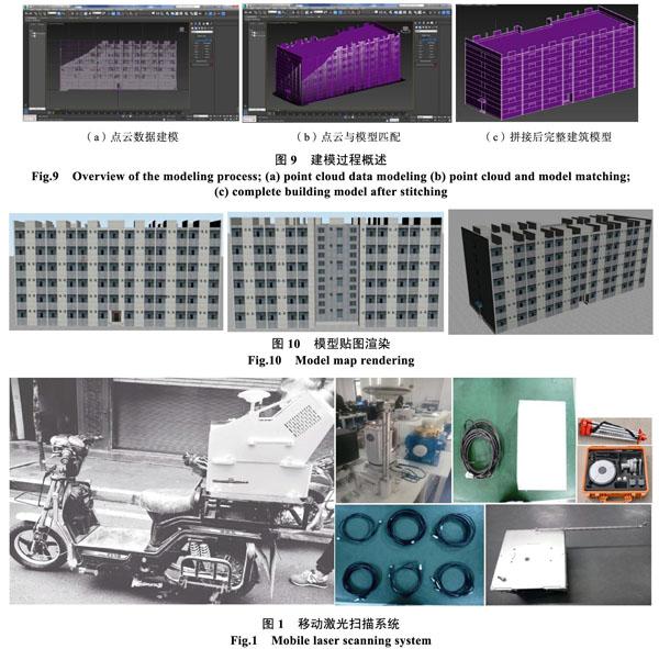

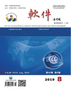
摘 要: 随着“数字城市”的发展,各行各业对空间数据需求不断增高,三维建模是“数字城市”的重要组成部分,传统的建筑物三维建模方法耗时耗力、精度低、采用接触式测量,这种采集方法和数据处理方式已不能满足数字化的需要。移动激光扫描技术的出现,改变了传统的的数据采集方式,为空间三维信息的获取提供了全新的技术手段。通过移动激光扫描技术获取的空间点云数据,可以建立结构错综和不规则场景的建筑物模型。鉴于传统方法的不足和移动激光扫描技术的特点,提出移动扫描技术三维建模的方法,以云南师范大学商学院的激光扫描为例,首先通过将获取的点云数据的配准、拼接、降噪、POS解算、IE解算和点云数据融合,然后进行精细三维建模。
关键词: 移动激光扫描技术;点云数据;三维建模
中图分类号: TP 3 文献标识码: A DOI:10.3969/j.issn.1003-6970.2019.08.038
本文著录格式:李小梅,李国柱. 基于移动激光扫描数据的建筑物精细化建模研究[J]. 软件,2019,40(8):163167+180
【Abstract】: With the construction of spatial data requirements in all walks of life in the digital city information era, urban 3D modeling is an important part of “digital city”. Traditional data acquisition methods and data processing modes can no longer meet the needs of digital informationization. The traditional building 3D modeling method is time-consuming and labor-intensive, has low precision, uses contact measurement, and can only obtain a small number of feature points and linear data of the building. The emergence of Mobile Laser Scanning (MLS) technology has changed the way of data collection and provided a new technical means for the acquisition of spatial three-dimensional information. Using the spatial point cloud data acquired by the mobile laser scanning technology, a three-dimensional model of a complex and irregular scene can be quickly established, and any distance, area, and volume measurement results can be quickly obtained. This paper proposes a method for 3D modeling using MLS data. Taking the laser scanning of the Business School of Yunnan Normal University as an example, through the registration, splicing, noise reduction, POS solution, IE solution and point cloud of point cloud data. Research on data processing technologies such as data fusion to solve the fine modeling using laser scanning technology. Building modeling accuracy using mobile laser scanning measurement methods to collect point cloud data is superior to traditional measurement methods. The research results can be applied to the restoration of cultural relics such as ancient buildings, deformation monitoring, virtual reproduction and so on.
【Key words】: MLS; Point cloud data; 3D modeling
0 引言
在全球數字化的时代,建筑物三维模型[1]在城市规划、城市管理以及重现等领域发挥着重要作用。建筑物三维建模的传统做法是采用人工测量技术,通过全站仪测量二维地形,并采集建筑物特征点高
程数据,根据CAD底图和高程数据在3ds Max中进行建模和贴图来制作三维模型。费时费力,对建筑模型数量多且结构复杂的数字城市工程并不适用。激光扫描(Laser Scanning)[2]是获取空间信息的全新手段,相比传统测量技术而言,激光测量技术算是一种新时势的测量技术。就光源的特性来讲,激光具有方向强、高亮度与良好的相干性等特点。就测量本身而言,激光扫描技术不受天气和雾霾能以非接触的方式釆集物体的空间信息。
猜你喜欢
科技创新与应用(2017年3期)2017-02-18
中小企业管理与科技·上旬刊(2016年12期)2017-01-05
科学与财富(2016年15期)2016-11-24
科技与创新(2015年15期)2015-08-04
科技与创新(2015年12期)2015-07-21