
Land surface roughness impacted by typical vegetation restoration projects on aeolian sandy lands in the Yarlung Zangbo River valley,southern Tibetan plateau
2022-09-26 05:10BojunZhngDonghongXiongYongfTngLinLiu
Bojun Zhng ,Donghong Xiong ,*,Yongf Tng ,Lin Liu
a Key Laboratory of Mountain Hazards and Earth Surface Process,Institute of Mountain Hazards and Environment,Chinese Academy of Sciences,Chengdu,610041,China
b College of Water Conservancy and Hydropower Engineering,Sichuan Agricultural University,Ya′an,625014,China
Keywords:Aeolian desertification Surface microtopographic variation Near soil surface characteristics Plant communities Yarlung Zangbo River valley
A B S T R A C T Aeolian sandy lands are widespread and desertification is recognized as one of the main environmental issues in the Yarlung Zangbo River valley,southern Tibetan plateau.The surface microtopographic variations induced by the near soil surface characteristics of plant communities are important compositions of land surface roughness,which likely influence wind erosion.This study was conducted to quantify the effects of typical vegetation restoration on land surface roughness on the aeolian sandy lands,and to identify the main influencing factors of land surface roughness in the Yarlung Zangbo River valley.Two bare sandy lands(as controls)and eight vegetated sandy lands with different restoration communities and ages were selected,and land surface roughness(LSR),as represented by surface microtopographic variations in this study,was measured by photogrammetric surveys.The results showed that LSR significantly increased by 7.9—16.8 times after vegetation restoration on the aeolian sandy lands,and varied among different restoration communities and ages.The mostly restored communities of Sophora moorcroftiana and Populus L.had greater LSR as compared to Artemisia wellbyi and Hedysarum scoparium.With succession from 6 to over 30 years,LSR gradually increased in the Sophora moorcroftiana restored sandy lands,but decreased in the Populus L.restored sandy lands.The variations of LSR were mainly attributed to the differences in near soil surface characteristics of vegetation(plant stem diameter and coverage,and plant residue density)and biological soil crusts(coverage and thickness).Mixed plantation of Populus L.and Sophora moorcroftiana was considered as the best restoration communities because of their effectiveness in increasing land surface roughness on the aeolian sandy lands in the Yarlung Zangbo River valley.The results would facilitate the understanding of the benefits of vegetation restoration in controlling wind erosion on the aeolian sandy lands.
1.Introduction
Aeolian desertification is one of the most serious ecological problems associated with land degradation through wind erosion on the Tibetan Plateau(Shen et al.,2012;Zhang et al.,2018).Aeolian desertified lands account for approximately 15%of the total area of the Tibetan Plateau(Zhang et al.,2018).In particular,aeolian sandy lands are widely distributed in the wide valleys of the Yarlung Zangbo River,where are densely populated and act as the Tibet's socioeconomic center(Shen et al.,2012).In the river valley,controlled by the westerly jet and mountain-valley topography,strong near-surface winds are frequent during winter and spring(Li et al.,1999;Zhang et al.,2019).Thus the wide river valleys have favorable environmental conditions for the development of aeolian sandy landforms,including the abundant sand material sources,strong near-surface winds,and wide development beds(Li et al.,1999).In recent decades,to control aeolian desertification,many vegetation restoration projects have been implemented on the sandy lands in these river valleys.Consequently,the ecological landscape has improved notably and the aeolian sandy land area has decreased greatly.For example,the area of sandy land in the middle part of the river valley decreased by 106.8 km2from 2015 to 2019(Zhan et al.,2021).A better understanding of the benefits of different vegetation restoration practices is critical for controlling aeolian desertification in the river valley.
The susceptibility of land to wind erosion is greatly controlled by the ground conditions.Vegetation cover and land surface roughness(LSR)are two main surface characteristics influencing wind erosion,and also are key input parameters in various types of wind erosion prediction models(Fryrear et al.,2000;Borrelli et al.,2016;Fenta et al.,2020;Jarrah et al.,2020).Generally,the effects of vegetation cover on threefold,that are reducing wind speed near the ground,providing an efficient shelter effect,and trapping transported sediment(Leenders et al.,2007;Fenta et al.,2020).Many previous studies have assessed the great reduction effect of vegetation cover on wind erosion intensity(Leenders et al.,2007;Meng et al.,2018;Chi et al.,2019;Liu et al.,2021).The roughness of land surface can enhance the frictional effects and is another important parameter to control wind velocity near the surface(Fryrear et al.,2000;Borrelli et al.,2016).For aerodynamic processes,roughness length(z0)has been widely used to describe the effective roughness of land surface to wind erosion,which is defined as the theoretical height above the surface at which the average wind velocity is extrapolated to zero(Zhang et al.,2004;Leenders et al.,2007;Kouchami-Sardoo et al.,2020).This roughness length cannot be directly measured but commonly extrapolated from the wind profiling(Zhang et al.,2004).
Vegetation is known as an importantLSRelement(MacKinnon et al.,2004;Leenders et al.,2007;Liu et al.,2021).Many studies have indicated that vegetation cover can significantly increase the aerodynamic roughness length.The increasing effects are closely related to the geometric shape,coverage,spatial arrangement,and canopy density of plants.However,aerodynamic roughness length may not be a reliable measure of the effects ofLSRon wind erosion under all vegetated conditions.Previous studies have shown that aerodynamic roughness length was generally low for the surface with sparse vegetation(MacKinnon et al.,2004;Fenta et al.,2020;Liu et al.,2021).In such cases,wind still can pass through the porous canopies and contact the ground surface.Moreover,the sparse plants may produce the“funnel effects”,which could speed up wind and increase erosion near the surface(Leenders et al.,2007;Chi et al.,2019).Therefore,using aerodynamic roughness length alone is insufficient to accurately quantify the effects ofLSRcaused by vegetation cover on wind erosion in sparsely vegetated lands.When analyzing the effect of surface roughness on water erosion,numerous studies have definedLSRas the variation of surface microtopography across an area(Rodríguez-Caballero et al.,2012;Ding&Huang,2017;Li et al.,2020;Zhu et al.,2020a,2020b).This type of microtopographic roughness has also been previously applied to describe the response of ground surface to airflow(Fick et al.,2020;He et al.,2018;Wu et al.,2020).Therefore,under the sparsely vegetated conditions,it is necessary to simultaneously quantify the changes ofLSRas represented by surface microtopographic variations due to the vegetation growth.
Vegetation growth can stimulate the changes of near soil surface characteristics,such as the plant stem and residue,biological soil crusts,and soil properties(Wang et al.,2018,2019;Zhu et al.,2020a,2020b).Plant stems and residues are important nearsurface covering in the vegetated areas,which can directly induce the significant variations in near surface elevation and thus lead to highLSR(He et al.,2018;Pierre et al.,2018;Zhu et al.,2020a,2020b).In arid and semiarid regions,biological soil crusts are extensively developed in the interspaces between the sparse vegetation(Wang et al.,2018,2019),and they play an important role in generating microtopography and enhancing effectiveLSR(Marticoren et al.,1997;Rodríguez-Caballero et al.,2012;Wang et al.,2017;Fick et al.,2020;Wu et al.,2020).The effects of biological crusts onLSRmainly depend on their developmental stage,coverage,and thickness.Soil properties(e.g.,soil texture,aggregates,and organic matter content)may change greatly with the growth of vegetation and biological crusts(Wang et al.,2018,2019),and hence greatly affectLSR.In general,large soil particles,such as the macroaggregates,are effective to increaseLSRand reduce wind erosion rate(Marticoren et al.,1997;Zamani & Mahmoodabadi,2013;Kouchami-Sardoo et al.,2020).Different vegetation species may lead to the differences in the above mentioned near soil surface characteristics,and thus induce the variations ofLSR(Zhu et al.,2020a,2020b).
In the Yarlung Zangbo River valley,the implementation of vegetation restoration projects on the aeolian sandy lands can alter the near soil surface characteristics considerably,which certainly have great effects onLSR.However,to date,the quantitative influences of vegetation restoration onLSRon the aeolian sandy lands in the river valleys are not fully understood.In terms of the special aeolian environments of strong near-surface valley winds and relatively sparse vegetation cover,LSRplays an important role in aeolian desertification process in the river valleys.Therefore,the specific objectives of this study were to quantify the variations ofLSRas reflected by surface microtopographic variations under different vegetation restoration projects on the aeolian sandy lands and to determine the dominant factors inducing these changes.The results are helpful for providing ideas for evaluating the control benefits of vegetation restoration on wind erosion and providing a scientific basis for policy makers to choose the suitable vegetation communities for vegetation restoration on the sandy landforms in the Yarlung Zangbo River valley.
2.Materials and methods
2.1.Study region
This study was conducted in the Shannan wide valley of the Yarlung Zangbo River,which represents the socioeconomic center of Tibet and has been seriously suffering from aeolian sand activity(Shen et al.,2012;Li et al.,2013).This valley is approximately 144 km long from east to west and generally 3—5 km wide,with an average elevation of 3600 m(Fig.1).The aeolian sandy lands in this wide valley account for approximately 20% of the total area of aeolian landforms in the Yarlung Zangbo River basin,which mainly distribute on river terraces,alluvial fans,piedmont alluvial-diluvial plains,and mountain slopes(Shen et al.,2012;Zhou et al.,2021).The wide valley has a temperate and semi-arid monsoon climate,with a mean annual rainfall of 300—450 mm and a mean annual daily temperature of 6.3—8.7°C(Li et al.,2013).Approximately 90%of precipitation falls in the rainy season from June to September.Controlled by the westerly jet circulation and mountain—valley topography,strong near-surface valley winds are frequent during winter and spring,with the annual mean wind velocity of 2.6 m s-1(Zhou et al.,2021).The dominant soils are sandy gravel soil and aeolian sandy soil with extremely coarse texture(Li et al.,2013).The dominant native shrub and grass species areSophora moorcroftiana,Artemisia wellbyi,andOrinus thoroldii,while the artificial forests are mainlyPopulusL.andSalix xizangensis(Li et al.,2013).
2.2.Testing sites selection
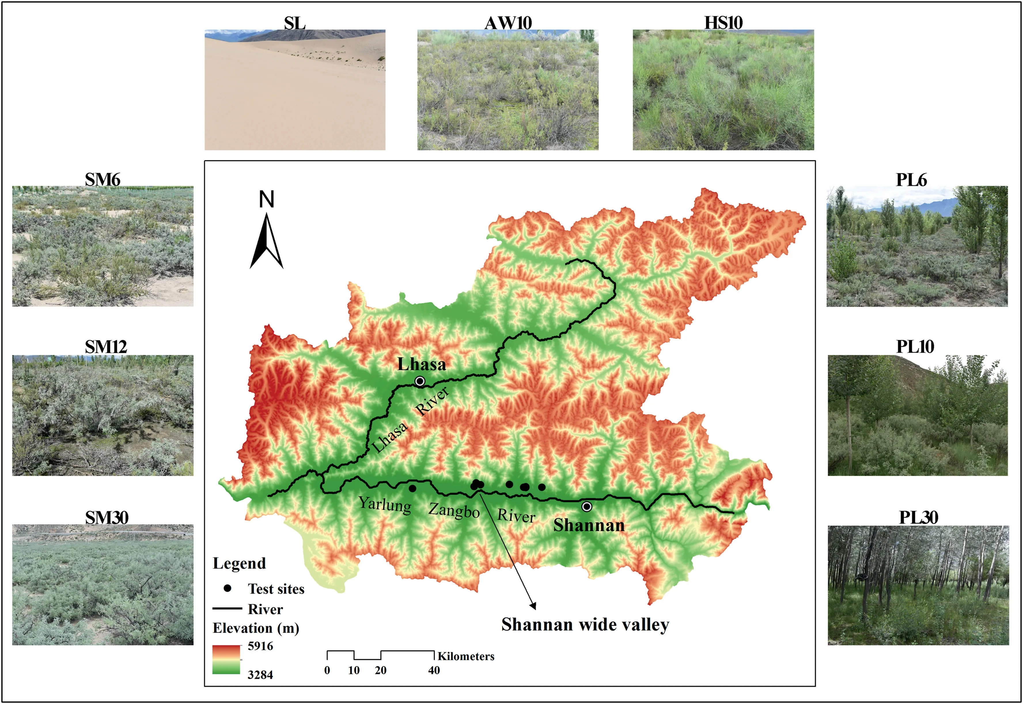
Fig.1.Locations of the study area and testing sites.SL-sandy land,AW-Artemisia wellbyi,HS-Hedysarum scoparium,SM-Sophora moorcroftiana,PL-Populus L.,respectively,and the suffix number is the restoration age in years.
Wind-deposited sandy lands on the valley floor account for the largest portion in the study region(Li et al.,1999;Shen et al.,2012;Zhou et al.,2021),and a series of vegetation restoration projects have been implemented to control this type of sandy landform since 1980s.After a detailed field survey,four vegetated sandy lands with different restoration communities(i.e.,Artemisia wellbyi,Hedysarum scoparium,Sophora moorcroftiana,andPopulusL.)were selected,and their restoration ages were approximately 10 years.For theSophora moorcroftianaandPopulusL.communities,two sandy lands with different restoration ages(i.e.,6 and over 30 years old)were also selected.Totally,eight vegetation-restored sandy lands were chosen as the test sites(Fig.1).In thePopulusL.lands restored for 6 and 10 years,Sophora moorcroftianadominates the understory cover,which can also be viewed as the mixed forest of these two species.The restoration ages of the testing sites were ascertained by consulting rangers or signboards.For comparison,two bare sandy lands were selected as controls,and their mean values were used for further analysis.These sites were selected as close as possible to minimize the potential effects of land form,elevation and soil on the interpretation of experimental results.In particular,all the selected sites are located on flat ground,where wind erosion is dominant.The basic information of each testing site is presented in Table 1.

Table 1Basic information of each testing site.
2.3.Land surface roughness measurement
LSRas reflected by surface microtopographic variations was measured by photogrammetric surveys in the field conditions in this study(Ding & Huang,2017;Zhu et al.,2020a,2020b).When collecting the topographical data,this method has a much higher accuracy than the conventional pin and chain methods(He et al.,2018;Wu et al.,2020),and is much easier to perform than the terrestrial laser scanning(Rodríguez-Caballero et al.,2012;Li et al.,2020).In general,the photogrammetry procedure mainly includes three steps of imaging acquisition,image-based 3D modelling,and roughness index calculation.This study mainly aims to quantify the changes ofLSRinduced by the near soil surface characteristics of plant communities on the aeolian sandy lands.Therefore,a 50 cm×50 cm rectangular aluminum frame was chosen and placed around the dominant vegetation species at three random positions for each test site(Fig.2a).The eight corners along the frame border were considered as the ground control points(GCPs)(Fig.2a).Considering the point 1 as the coordinate origin,the threedimensional coordinates of seven other GCPs were determined using their relative distances to the point 1(Zhu et al.,2020a,2020b).Prior to the photographic recording,plant residues and biological soil crusts covering on land surface within the frame remained undisturbed,while the plant stems were clipped to a uniform height of approximately 3 cm in this study.This treatment of stem height was mainly according to the measurements of previous studies that the aerodynamic roughness length(z0)of a surface with sparse vegetation cover was generally at millimeter to centimeter scales(MacKinnon et al.,2004;Fenta et al.,2020;Liu et al.,2021).

Fig.2.Image of the measuring frame(a)and example of a generated DEM(b).
A reflex Nikon D750 camera(50 mm fixed focal length,3752×2504 pixels)was used for collecting land surface images from a height of approximately 1.5 m and from different viewpoints around the frame,when there was no direct irradiance from the sunlight.Based on the images and GCPs coordinates,the dense point clouds in 3D coordinates of all testing plots were automatically produced by the Agisoft PhotoScan 1.2.5 professional software,with no special camera calibration required.The numbers of selected photographs were approximately 30 for each testing plot,which could fully cover the testing area and have a minimum overlap of 50% between each other.When generating dense point clouds,the root mean square errors of the GCPs were approximately 0.002 m for all testing plots,which were satisfactory for the production of highly accurate 3D models.Then,digital elevation models(DEMs)were automatically built for all testing plots in the Agisoft PhotoScan software,with a uniform cell size of approximately 0.4 mm.Finally,the generated DEMs were clipped to the exact size of 50 cm×50 cm based on interior borders of the frame in the ArcGIS 10.2 software(Fig.2b).LSRwas determined by calculating the standard deviation of the mean elevation of all grids after removing the effect of slope.This roughness index was widely used to describe the microtopographic changes due to the presence of variations in height like the near soil surface characteristics of plants(Rodríguez-Caballero et al.,2012;Zhu et al.,2020a,2020b).

whereLSRis land surface roughness as represented by surface microtopographic variations(mm),u(xi)is the mean elevation of the gridxi(mm),uis the average grid elevation of DEM(mm),andNis the grid numbers.
2.4.Measurements of near soil surface characteristics
After the measurements ofLSR,near soil surface characteristics were simultaneously measured within the same testing plots at each site.For each testing plot,the coverages of plant residues and biological crusts were estimated by a quadrat method with two replicates,and the biological crust thicknesses were measured using a caliper with an accuracy of 0.01 mm for fifteen replicates(Wang et al.,2018,2019).All plant residues were collected,washed and oven-dried to calculate the plant residue density(kg m-2).All plant stems were counted and measured the diameter with the caliper,and then the stem coverage was estimated through dividing the quadrat area(50 cm×50 cm).Furthermore,for each testing plot,the bulk density was measured for two replicates using steel rings(5 cm in height,5 cm in diameter)and oven-drying method,and a mixed topsoil sample was collected,air-dried and sieved to determine the particle size distribution(PSD,smaller than 2 mm in diameter,Malvern Mastersizer 2000)and organic matter content(potassium dichromate volumetric method).ThePSDwas classified into fractions of<2 μm,2—50 μm,50—100 μm,100—250 μm,250—500 μm,and 500—2000 μm.
2.5.Statistical analysis
The differences inLSRand near soil surface characteristics between control and vegetation-restored sandy lands and among different vegetation projects were detected by the one-way analysis of variance(ANOVA)followed by the least significant difference method(P<0.05).The relationships betweenLSRand near soil surface characteristics were analyzed by the Pearson correlation analysis and simple regression method.The analysis results were evaluated by the coefficient of determination(R2),Pearson correlation coefficient,and Nash—Sutcliffe model efficiency coefficient(NSE).All statistical analyses were carried out by the SPSS 20.0 software(SPSS Inc.,Chicago,IL,USA)and Origin Pro 2015 software(OriginLab Corp.,Northampton,MA,USA).
3.Results
3.1.Near soil surface characteristics under different vegetation projects
Vegetation restoration on the aeolian sandy lands induced great changes of near soil surface characteristics(Tables 2 and 3).For the vegetation-restored sandy lands,the silt and very fine sand contents were 24.5—143.8 and 3.3—6.6 times greater,while the medium and coarse sand contents were 55.5%—91.6% and 39.7%—100.0%lower than those of control,respectively(P<0.05)(Table 2).These results indicated that vegetation restoration on the aeolian sandy lands caused the surface sediments gradually become finer.Compared to the control,the bulk density of vegetation-restored sandy lands significantly decreased by 8.4%—39.3%,while the organic matter contents significantly increased by 8.3—149.4 times(P<0.05)(Table 2).
Compared to the control,vegetation restoration also caused the biological crusts,plant stems and residues widely covering on the ground surface(Table 3).The plant stems and residues are essential parts of near soil surface characteristics with vegetation growth.In this study,the plant stem diameter and coverage ranged from 4.70 to 12.07 mm and 0.14%—0.98%,while the plant residue coverage and density ranged from 20.50% to 98.50% and 0.09—0.48 kg m-2,for different vegetated sandy lands,respectively.With the vegetation restoration,the biological crusts developed in most restored sandy lands,with its coverage and thickness ranging from 6.33%to 57.50% and 6.72—30.62 mm,respectively.
Among four different restoration communities,near soil surface characteristics showed intricately statistical differences(Tables 2 and 3).For theSophora moorcroftianaandPopulusL.communities,near soil surface characteristics also differed greatly with the increase of restoration age,but no distinguishable trend was observed for most near soil surface characteristics(Tables 2 and 3).The differences in near soil surface characteristics between control and vegetation-restored sandy lands and among different vegetation projects likely have great effects onLSR.
3.2.Land surface roughness under different vegetation projects
LSRsignificantly changed after vegetation restoration on the aeolian sandy lands(Figs.3 and 4).The measuredLSRof the control plots ranged from 0.89 to 1.14 mm,with a mean of 1.02 mm.For the different vegetation projects,the minimumLSRranged from 8.40 to 15.46 mm,whereas the maximumLSRranged from 9.47 to 20.59 mm,and the means ranged from 9.02 to 18.12 mm.The meanLSRvalues of all vegetation-restored sandy lands were almost an order of magnitude greater than that of control.These results indicated that vegetation restoration is effective to enhance land surface roughness on the aeolian sandy lands in the Yarlung Zangbo River valley.
After approximately 10 years restoration,the meanLSRvaried among different communities(Fig.3).LSRnumerically decreased in the order ofSophora moorcroftiana(13.04 mm),PopulusL.(12.36 mm),Hedysarum scoparium(11.33 mm),andArtemisia wellbyi(11.00 mm),respectively.The meanLSRof the different restoration communities was 9.80—11.80 times significantly greater than that of control(P<0.05).With vegetation succession from 6 to over 30 years,LSRalso showed great differences(Fig.4).In theSophora moorcroftianarestored sandy lands,the meanLSRgradually increased from 11.70 to 18.12 mm,while it gradually decreased from 13.70 to 9.02 mm in thePopulusL.restored sandy lands.Compared to the control,theLSRmeasured in theSophoramoorcroftianaandPopulusL.restored sandy lands increased by 7.9—16.8 times.For thePopulusL.lands restored for 6 and 10 years,Sophora moorcroftianadominates the understory cover(Table 1).These results indicated that the growth ofSophora moorcroftiana,acted as the native shrub species,is likely more effective to enhanceLSRthan other grass and shrub species on the aeolian sandy lands.

Table 2Soil properties of each testing site.
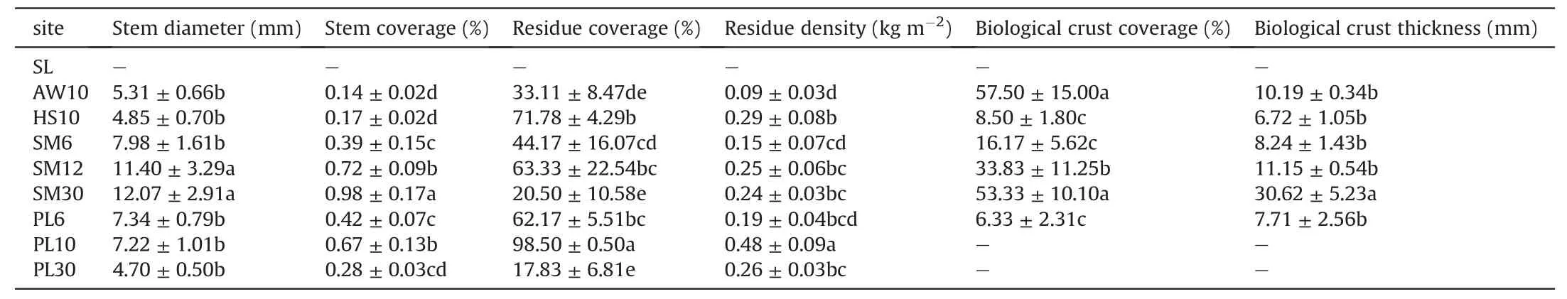
Table 3Characteristics of vegetation and biological crusts of each testing site.

Fig.3.Land surface roughness under different vegetation restoration communities.SLsandy land,AW-Artemisia wellbyi,HS-Hedysarum scoparium,SM-Sophora moorcroftiana,PL-Populus L.,respectively,and the suffix number is the restoration age in years.Error bars represent the standard deviation.Different letters indicate that the differences are significant at P<0.05.
4.Discussion
4.1.Land surface roughness impacted by vegetation restoration
Vegetation is commonly used as the dominant measure for protecting soil surfaces from wind erosion.Vegetation cover can significantly increase aerodynamic roughness length and reduce wind speed near the ground(Leenders et al.,2007;Meng et al.,2018;Liu et al.,2021).In current study,the implementation of vegetation restoration projects on the aeolian sandy lands certainly increased the aerodynamic roughness length as compared to the bare sandy surface.However,vegetation cover in most restored sandy lands were relatively sparse,as evidenced by the high porosity(Table 1).According to the previous studies,aerodynamic roughness length was usually at the millimeter to centimeter scales in the sparsely vegetated lands(MacKinnon et al.,2004;Liu et al.,2021).Therefore,the increases of aerodynamic roughness length caused by vegetation restoration may be limited in most vegetated sandy lands in this study.In the Yarlung Zangbo River valley,aeolian process is mainly driven by the strong near-surface valley winds(Li et al.,1999).In such aeolian environments,wind can still pass through the porous vegetation and contact the ground surface.
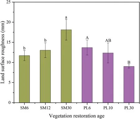
Fig.4.Variations in land surface roughness with vegetation restoration age.SMSophora moorcroftiana,PL-Populus L.,respectively,and the suffix number is the restoration age in years.Error bars represent the standard deviation.Different letters in the same community indicate that the differences are significant at P<0.05.
For the sparsely vegetated surface,studies have indicated that the microtopographic irregularities due to the presence of plants are also essential to protect the surface against wind erosion(MacKinnon et al.,2004).In this study,the measuredLSRreflected by surface microtopographic variations was of the order of 1 mm in the bare sandy land.With vegetation restoration,LSRsignificantly enhanced on the aeolian sandy lands,and the measuredLSRunder different vegetation projects varied from 8.40 to 20.59 mm(Figs.3 and 4).The measuredLSRvalues in this study are the same order of magnitude with those aerodynamic roughness lengths reported in the sparsely vegetated lands(MacKinnon et al.,2004;Liu et al.,2021).This result confirmed thatLSRas reflected by surface microtopographic variations was also important to quantify the effectiveness of vegetation cover in controlling wind erosion on the aeolian sandy lands.AllLSRmeasured in this study belonged to the range of random roughness.Previous studies have proven that this type of land surface roughness was an important indicator of wind erosion rate(Fryrear et al.,2000;He et al.,2018;Jarrah et al.,2020).LSRof vegetation-restored lands were significantly greater than that of control.This result is also consistent with previous studies,thatLSRcould significantly improve with vegetation growth(Richards et al.,2013;Zhu et al.,2020a,2020b).
LSRvaried among different vegetation restoration communities and ages in this study(Figs.3 and 4).This result is consistent with the findings of Zhu et al.(2020a,2020b)that reported on abandoned farmland.For different restoration communities,theSophora moorcroftianaandPopulusL.had relatively higherLSR,and then followed byHedysarum scopariumandArtemisia wellbyi(Fig.3).With the increase of restoration age,LSRincreased in theSophora moorcroftianarestored sandy lands,but decreased in thePopulusL.restored sandy lands(Fig.4).These differences were most likely attributed to the differences in near soil surface characteristics caused by the different vegetation growth and their succession(Richards et al.,2013;Wang et al.,2018,2019;Zhu et al.,2020a,2020b).In thePopulusL.lands restored for 6 and 10 years,Sophora moorcroftianadominates the understory vegetation,while in thePopulusL.land restored over 30 years,the near surface is mainly covered by annual or perennial herbs(Table 1).Therefore,in this study,we can conclude that the growth ofSophora moorcroftianaseems to be more effective in increasingLSRthan other grass and shrub species on the aeolian sandy lands.However,trees are generally large objects and are expected to be more effective in extracting momentum from the air(Leenders et al.,2007).Thus in thePopulusL.restored sandy lands,the high canopy likely promotes greater aerodynamic roughness than other vegetation restoration projects.Especially,the height and width of the canopy ofPopulusL.will gradually increase with restoration age,which certainly lead to the progressively increasing in aerodynamic roughness.Therefore,althoughLSRdecreased with restoration age in thePopulusL.restored sandy lands,the gradual increase of aerodynamic roughness can effectively dissipate the wind erosivity near the ground and reduce wind erosion.
As discussed above,vegetation restoration is effective to increase land surface roughness on the aeolian sandy lands in the Yarlung Zangbo River valley.BothPopulusL.andSophora moorcroftianaare crucial roughness elements,and thus their combination can be considered as the best restoration communities on the aeolian sandy lands.However,their optimal arrangement in the field needs further studies.Previous studies have also demonstrated that the mixed forest of trees and shrubs can be effective to protect the surface from wind erosion in drylands(Leenders et al.,2007;Chi et al.,2019).Furthermore,more studies are needed to quantify the relationship between land surface roughness and restoration age during the natural ecological succession process in the Yarlung Zangbo River valley,which can provide more scientific suggestions for managing vegetation restoration projects,such as the enclosing time.Intensive human disturbance(e.g.grazing)could decrease the vegetation cover and thus the land surface roughness(Pierre et al.,2018;Wu et al.,2020).
4.2.Main factors influencing land surface roughness
With vegetation restoration on the aeolian sandy lands,the vegetation characteristics(i.e.,plant stem and residue)greatly changed(Table 3).Previous studies have demonstrated that the presence of plant stems and residues can cause great spatial variability of surface elevation,and thus directly increaseLSR(He et al.,2018;Pierre et al.,2018;Zhu et al.,2020a,2020b).In this study,plant stems and residues obviously covered on the sandy surface following vegetation growth,and their diameter,coverage or density varied greatly due to the differences in plant species and restoration ages(Table 3).The correlation analysis showed thatLSRwas significantly positively correlated to plant stem diameter,stem coverage and residue density in this study(Table 4).LSRincreased exponentially with plant stem diameter,and increased linearly with plant stem coverage and plant residue density,with the coefficients of determination of 0.55,0.54,and 0.27,respectively(Fig.5).These results agree with the findings of some previous studies.He et al.(2018)and Pierre et al.(2018)both reported that the maintaining of crop residue could effectively increaseLSRand decrease wind erosion,and the increasing effects are related to the residue stubble height,amount and coverage.Zhu et al.(2020a,2020b)found that vegetation restoration markedly promoted the accumulation of plant residues and stems,andLSRsignificantly increased with plant stem diameter,residue coverage,residue thickness,and residue density.However,the plant residue and stem traits(i.e.type,composition,and decomposition rates)are actually quite different among different plant communities and succession stages,which likely have different effects onLSR.Further studies are needed to quantify the effects of plant residue-stems onLSRincluding additional residue-stem traits on the aeolian sandy lands.
Biological soil crusts are common ground cover in the interplant areas in most arid and semiarid ecosystems(Wang et al.,2018,2019;Wu et al.,2020).In this study,with the vegetation restoration,biocrusts were widely developed on the aeolian sandy lands,and their coverage can reach approximately 60%(Table 3).Many studies have shown that the formation and development of biocrusts can roughen land surface,which could effectively promote not only the aerodynamic roughness length(Marticorena et al.,1997;Fick et al.,2020)but also the surface microtopographic variations(Rodríguez-Caballero et al.,2012;Wang et al.,2017;Wu et al.,2020).The increasing effects are closely related to their type,coverage and developmental stage.In this study,LSRwas significantly positively correlated to the biological crust coverage and thickness(Table 4,Fig.6).It is well known that the thickness of biocrusts closely depends on their dominant type or developmental stage(Wang et al.,2018,2019).Generally,later successional moss crusts have much greater thicknesses than the early successional cyanobacteria crusts.Thus,the moss crusts could confer greaterLSRthan those cyanobacteria crusts(Rodríguez-Caballero et al.,2012;Wang et al.,2017).Besides increasingLSRdirectly,biocrusts can also bind and bond fine soil particles together to create a relatively thin layer at the land surface,and the covered areas suffer less erosion(Wang et al.,2017;Fenta et al.,2020).This spatial heterogeneity in biocrusts also has a great increasing effect onLSRin this study.
With the growth of vegetation and biological crusts,soil properties altered greatly on the aeolian sandy lands(Table 2).In this study,clay particles were almost absent and sand grains were the dominant particles in the surface sediments of aeolian sandy lands.This result confirms the findings of previous studies conducted in the same study region(Zhang et al.,2019;Zhou et al.,2021).However,compared to the control,in the vegetation-restored sandy lands,the silt and very fine sand contents significantly increased,while the medium and coarse sand contents significantly decreased(Table 2).This result also implied that vegetation restoration on the aeolian sandy lands has effectively increased the contents of fine particles and gradually transformed the soil texture from sandy to loamy.Furthermore,the soil bulk density significantly decreased and organic matter content significantly increased with vegetation restoration on the aeolian sandy lands(Table 2).The correlation analysis revealed thatLSRsignificantly correlated with very fine,medium and coarse sand contents(Table 4).Previous studies have indicated that large soil particles,such as macroaggregates,led to a great spatial variation in land surface elevation,and thus contributed to increaseLSR(Marticorena et al.,1997;Zamani & Mahmoodabadi,2013;Zhu et al.,2020a,2020b).However,in this study,large sand grains are adverse to the formation of aggregates on the aeolian sandy lands.Therefore,although the significant correlations presented,the changes of soil properties likely have limited effects on the increase ofLSR.

Table 4Correlation coefficients between land surface roughness and near soil surface characteristics.
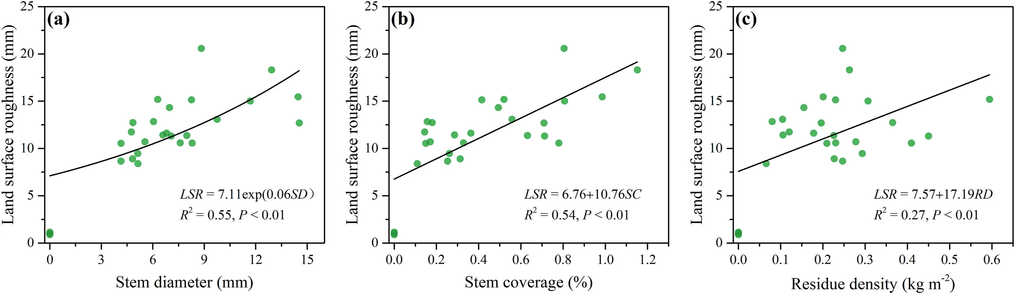
Fig.5.Relationships between land surface roughness and plant stem diameter(a),stem coverage(b),and residue density(c).

Fig.6.Relationships between land surface roughness and biological crust coverage(a)and thickness(b).
4.3.The impact of vegetation on land surface roughness estimation
Given the time-consuming nature of field measurements,it is necessary to estimateLSRfrom easily measurable near soil surface characteristics of plant communities after vegetation restoration on the aeolian sandy lands.As discussed above,vegetation properties(i.e.,plant stem and residue)and biological soil crusts had great effects on the increase ofLSRon the aeolian sandy lands after vegetation restoration.Therefore,these near soil surface characteristics were mainly considered to estimateLSR.Plant stem coverage showed more apparent differences among different vegetated lands as compared to the stem diameter(Table 3).The changes of the thickness of biological soil crusts can well reflect their successional stage(Wang et al.,2018,2019),and showed more significant correlation withLSRthan the biological crust coverage(Table 4).Hence plant stem coverage and biological crust thickness were selected for further analysis.In addition,plant residue density was employed in the estimation.The results demonstrated that the changes ofLSRon the aeolian sandy lands could be effectively estimated by using the plant stem coverage,plant residue density,and biological crust thickness(Fig.7).The performance of the developed model was satisfactory(R2=0.77 andNSE=0.76).However,some scatter points still existed far from 1:1 line.Further studies are needed to develop the applicability of this equation for land surface roughness estimation under more different vegetation restoration projects on the aeolian sandy lands.
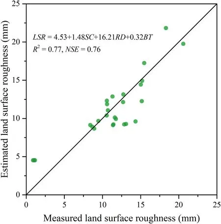
Fig.7.Measured land surface roughness vs.estimated ones using plant stem coverage,plant residue density and biological crust thickness.
5.Conclusions
This study was carried out to quantify the effects of typical vegetation restoration on land surface roughness as reflected by surface microtopographic variations on the aeolian sandy lands and to identify the main influential factors of land surface roughness in the Yarlung Zangbo River valley,southern Tibetan plateau.
(1)Vegetation restoration significantly enhanced land surface roughness on the aeolian sandy lands,and the increasing effectiveness varied among different restoration communities and ages.The meanLSRof vegetation-restored sandy lands ranged from 9.02 to 18.12 mm and significantly increased by 7.9—16.8 times compared to the control.TheSophora moorcroftianaandPopulusL.communities had relatively higherLSR.With succession from 6 to over 30 years,LSRincreased in theSophora moorcroftianarestored sandy lands,but decreased in thePopulusL.restored sandy lands.
(2)The variations ofLSRwere mainly attributed to the changes of vegetation properties(i.e.,plant stem and residue)and biological soil crusts induced by different vegetation growth and their succession.LSRsignificantly increased with plant stem diameter,stem coverage,residue density,biological crust coverage and thickness.The changes ofLSRafter vegetation restoration could be well estimated by plant stem coverage,plant residue density,and biological crust thickness(NSE=0.76).
(3)The mixed forest ofPopulusL.andSophora moorcroftianacan be considered as the best restoration communities to improve land surface roughness on the aeolian sandy lands.PopulusL.trees are effective at increasing aerodynamic roughness,while the native shrubs ofSophora moorcroftianaare effective at increasing surface microtopographic variations.These results are helpful for deeply understanding the benefits of vegetation restoration in controlling wind erosion on the aeolian sandy lands in the Yarlung Zangbo River valley.
Declaration of competing interest
The authors declare that they have no known competing financial interests or personal relationships that could have appeared to influence the work reported in this paper.
Acknowledgements
This work was supported by the Second Tibetan Plateau Scientific Expedition and Research Program(2019QZKK0404),the Strategic Priority Research Program of the Chinese Academy of Sciences(XDA20020401),and the“Light of West China”Program of the Chinese Academy of Sciences(E0R2180).The authors also greatly appreciate the invaluable comments from the reviewers and editors.
 International Soil and Water Conservation Research2022年1期
- International Soil and Water Conservation Research的其它文章
- An updated isoerodent map of the conterminous United States
- Monitoring gully erosion in the European Union:A novel approach based on the Land Use/Cover Area frame survey(LUCAS)
- Unpaved road erosion after heavy storms in mountain areas of northern China
- Determination of rill erodibility and critical shear stress of saturated purple soil slopes
- Erosion risk assessment:A contribution for conservation priority area identification in the sub-basin of Lake Tana,north-western Ethiopia
- Mapping soil erodibility in southeast China at 250 m resolution:Using environmental variables and random forest regression with limited samples