
Characteristics and evaluation of Mesozoic source rocks in the southeastern East China Sea continental shelf
2019-01-12 05:55MingjianWangGuolinXiaoChangqingYangYanqiuYangXiChenLongHuang
China Geology 2019年2期
Ming-jian Wang , Guo-lin Xiao , Chang-qing Yang , Yan-qiu Yang , Xi Chen, Long Huang
a Qingdao Institute of Marine Geology, China Geological Survey, Ministry of Natural Resources, Qingdao 266071, China
b Laboratory for Marine Mineral Resources, Qingdao National Laboratory for Marine Science and Technology, Qingdao 266071, China
c North China Sea Air-borne Detachment of China Marine Surveillance, Qingdao 266000, China
Keywords:
East China Sea continental shelf
Southeastern part
Mesozoic
Source rocks
Evaluation
A B S T R A C T
Source rocks are the material basis of oil and gas generation and determine the potential resources of exploration blocks and have important research value. This paper studies the lithology, thickness, and geochemistry of Mesozoic source rocks in the southeastern East China Sea continental shelf. The results show that the Mesozoic source rocks are mainly dark mudstone and coal-bearing strata. The total thickness of Lower-Middle Jurassic source rocks ranges from 100 m to 700 m, and that of Lower Cretaceous source rocks ranges from 50 m to 350 m. The overall thickness of Mesozoic source rocks is distributed in the NE direction and their thickness center is located in the Jilong Depression. The Lower-Middle Jurassic source rocks are mainly developed shallow marine dark mudstone and transitional coal measure strata. Those of the Lower Cretaceous are mainly mudstone of a fan delta front. Lower-Middle Jurassic and Lower Cretaceous hydrocarbon source rocks are dominated by type III kerogen, with Lower-Middle Jurassic hydrocarbon source rocks having high organic matter abundance and being medium-good hydrocarbon source rocks, while Lower Cretaceous hydrocarbon source rocks have relatively poor quality. From northwest to southeast, the vitrinite reflectance Ro of Mesozoic source rocks increases gradually. Source rocks in the study area are divided into three types. The first hydrocarbon-generating area is mainly located in the southeastern region of the study area, and the Jilong Depression is the hydrocarbongenerating center. The results of this study can provide a basis for exploration of Mesozoic oil and gas resources in the southeastern East China Sea continental shelf.
1. Introduction
The East China Sea Shelf Basin is a large Mesozoic-Cenozoic superimposed petroleum basin. Since the Mesozoic, it has undergone multistage tectonic movement,resulting in complicated geological conditions (Li G et al.,2012; Zhang GH and Zhang JP, 2015; Yang YQ et al., 2016;Jiang DH et al., 2017; Yang CQ et al., 2017; Yang CS et al.,2018). Oil and gas exploration of this basin can be divided into two stages. Before 2005, exploration mainly focused on the Cenozoic. With the improvement of seismic acquisition and processing technology, the Mesozoic has now been well revealed, and oil and gas exploration has been gradually shifted to the deep layer (Yang CQ et al., 2017). Considerable research has been conducted in the East China Sea Shelf Basin and many achievements have been made in understanding the basin’s structure and evolution, the Mesozoic prototype basin, the dynamic mechanism of basin formation, trap development, and reservoir characteristics(Feng XJ et al., 2003; Liu JH et al., 2007; Jiang XY and Fu ZF, 2010; Yang CQ et al., 2012, 2017; Gong JM et al., 2013;Zhao HQ et al., 2014; Zhang JP et al., 2014; Zhang GH and Zhang JP, 2015; Zhang T et al., 2015; Guo Z et al., 2015; Li DY et al., 2015; Jin CS et al., 2015; Su Ao et al., 2015; Liang J et al., 2016; Cong Y et al., 2016; Jiang DH et al., 2017; Yao G et al., 2018; Yang CS et al., 2018; Zhong K et al., 2018;Wang MJ et al., 2018). The Mesozoic basin in the East China Sea shelf area is considered to offer good oil and gas geological conditions and is one of the important strategic succession areas for oil and gas exploration in China (Gong JM et al., 2013; Liang RB, 2017; Yang CS et al., 2018; Duan XY et al., 2018; Geng YS et al., 2018; Wang GL et al., 2018;Zhai GY et al., 2018a, b). Source rocks are the material basis of hydrocarbon generation and determine the potential resources of an area, the basis for hydrocarbon resource evaluation (Wang MJ et al., 2011, 2016, 2018). However, up to now, no systematic studies or evaluations of the Mesozoic source rocks in the southeastern East China Sea continental shelf have been conducted, which restricts our understanding of the hydrocarbon resource potential in the study area. On the basis of previous research, in this paper we analyze Mesozoic source rock characteristics in the study area, including source rock lithology, thickness, organic matter abundance, type, and maturity, and set criteria for source rock evaluation.According to the criteria, we evaluated the Mesozoic source rocks in the study area and analyzed their horizontal distribution law, which provides a basis for the evaluation of oil and gas resources in the study area.
2. Regional geological background
The East China Sea Shelf Basin is located at the eastern edge of the Eurasian plate. Its formation and evolution are controlled by the interaction of the Eurasian plate, the Pacific-Philippine plate, and the Indian plate. The Mesozoic is the most important period for tectonic change in eastern China. It has evolved from an Indosinian tectonic domain in the Triassic to a coastal Pacific tectonic domain since the Jurassic. The tectonic stress field has been transformed many times, and the tectonic characteristics and basin evolution process are very complex. The eastern side of the East China Sea Shelf Basin is the Diaoyu Island magma belt, the southern side is adjacent to the Taixi basin, the western side is close to the Zhemin uplift area, and the northern side is separated with the South Yellow Sea basin by the uplift.
The East China Sea Shelf Basin is controlled by NE-NNE trending faults with NE belt and NW zone characteristics.There are three secondary tectonic units from west to east: the western sag, the central uplift zone, and the eastern sag. The secondary tectonic units can be divided into eight tertiary tectonic units, such as the Changjiang Depression and the Hupijiao Lift (Fig. 1), which constitute the typical basin-mountain system of the western pacific. This study covers the southeastern part of the East China Sea Shelf Basin, including the Oujiang Depression, Yandang Low Lift,Minjiang Depression, Taipei Low Lift, and Jilong Depression.

Fig. 1. Tectonic map of the East China Sea Shelf Basin.
3. Characteristics of Mesozoic source rocks
As a Mesozoic subsidence zone in the continental shelf of the East China Sea, both Jurassic and Cretaceous source rocks have been drilled in the study area (wells FZ13-2-1 and FZ10-1-1). These two wells are located at the junction of the Yandang Low Lift and the Minjiang slope zone. Through drilling sampling analysis of these two wells, the Lower-Middle Jurassic is found to be the main source rock development interval in the area, followed by the Lower Cretaceous.
3.1. Lower-Middle Jurassic source rocks
At present, drilling and seismic data reveal that Jurassic source rocks are mainly developed in the Minjiang Depression. Although no drilling has been conducted,interpretation of seismic data shows that the Jurassic source rocks are also well developed in the Jilong Depression. The Minjiang Depression has two sedimentary centers located in the north and south. The sedimentary thickness in the south ranges from 1500 m to 4500 m with burial depths of 5000-10000 m while the sedimentary thickness in the north ranges from 1000 m to 3500 m with burial depths of 3000-8000 m. The thickness center is located in the Jilong Depression, which is distributed in the NE direction. The sedimentary thickness ranges from 1500 m to 4000 m with depths being more than 5000-13000 m. The Upper Jurassic rocks comprise a set of variegated and red clastic rocks,belonging to fluvial facies deposited in an oxidized environment, with low organic matter abundance and total organic carbon (TOC) content generally <0.5%. The Upper Jurassic rock is not subject to hydrocarbon-generation conditions and is comprehensively evaluated as nonhydrocarbon source rock. The Fuzhou Formation of the Lower-Middle Jurassic is a set of dark clastic rocks with several layers of coal seams or carbonaceous mudstones,which are mainly fluvial-lacustrine deposits and partly shallow-marine clastic rocks with several coal seams or coal lines.
Wells FZ13-2-1 and FZ10-1-1 reveal that the Lower-Middle Jurassic source rocks in the East China Sea shelf basin are mainly developed in the Fuzhou Formation,and the lithology is dark mudstone of littoral-shallow marine facies and coal measures of transitional marine-continental facies. The results of test analysis indicate that the organic matter content of dark mudstone in the Fuzhou Formation of the Lower-Middle Jurassic varies greatly. The average TOC value of mudstone in the Fuzhou Formation (well FZ13-2-1)is 0.36% with average rock pyrolysis parameter values(S1+S2) being 0.34 mg/g. The mudstone in the Fuzhou Formation (well FZ13-2-1) is evaluated as poor source rock.Gray-black mudstone and black mudstone were drilled in the Lower-Middle Jurassic Fuzhou Formation at depths of 3378-3382 m of well FZ10-1-1. Cracks were well developed and filled with bitumen (Fig. 2). Through the analysis of core samples in well FZ10-1-1, we found that the organic carbon content of dark mudstone in the Fuzhou Formation (well FZ10-1-1) of the Lower-Middle Jurassic generally ranged from 0.69% to 0.98% with a maximum of 1.24%. The pyrolysis (S1+S2) pyrolysis parameter values ranged from 0.63 mg/g to 1.97 mg/g. The dark mudstone of the Lower-Middle Jurassic in this well is moderate abundant source rocks. However, the organic matter content of the coal measures source rocks in well FZ10-1-1-1 can reach 75%, and the pyrolysis (S1+S2) parameter values range from 155 mg/g to 169.6 mg/g. The coal measures source rocks belong to high abundance source rocks.

Fig. 2. Cores from the Fuzhou Formation in the Lower-Middle Jurassic (well FZ10-1-1; 3378-3382 m).
The organic matter types of dark mudstones in the Fuzhou Formation of the Middle Jurassic (wells FZ10-1-1 and FZ13-2-1) are mostly type III and a few of them are type II2 (Fig. 3),generally belonging to humic gas source rocks. The source rock vitrinite reflectance (Ro) is >0.80% and the rock has entered the mature stage.

Fig. 3. TOC content and pyrolysis S1+S2 numerical scatter plot of mudstones in the Fuzhou Formation of the Lower-Middle Jurassic drilled in the southern East China Sea.
3.2. Lower Cretaceous source rocks
Cretaceous rocks are widely distributed, as has been revealed by wells FZ13-2-1 and FZ10-1-1 in the Minjiang Depression in the southeastern part of the East China Sea shelf basin. Cretaceous strata are mainly red continental clastic rock deposits. Fan delta facies deposits are developed in the Yushan Formation of the Cretaceous (well FZ13-2-1)with TOC values of mudstone samples ranging from 0.07% to 0.89% (with an average value of 0.25%). The pyrolysis(S1+S2) parameter values mainly range from 0.04 mg/g to 1.09 mg/g, with an average of 0.24 mg/g. The organic matter abundance of mudstone is relatively low. The Yushan Formation of the Cretaceous in well FZ10-1-1 mainly developed lacustrine facies. The TOC values of mudstone ranged from 0.01% to 0.08%, averaging 0.04%, and pyrolysis(S1+S2) parameter values ranged from 0.03 mg/g to 0.08 mg/g, averaging 0.05 mg/g. These two indicators reveal that the organic matter abundance of the Lower Cretaceous in the well location is low.
From theTmax-hydrogen index diagrams of the mudstones in the Yushan Formation of the Cretaceous (wells FZ13-2-1 and FZ10-1-1), it can be seen (Fig. 3) that the hydrogen index ranges from 57.00 mg/g to 113 mg/g, with an average of 75.0 mg/g, and that the peak temperature of pyrolysis is 444°C.The organic matter of the mudstone is type III, which belongs to humic kerogen and has entered the mature stage.
It should be pointed out that, during the Jurassic and Early Cretaceous sedimentary periods, wells FZ13-2-1 and FZ10-1-1 were located in relatively high topography, shallow-water bodies and developed shore-shallow lake facies with low organic matter abundance. Therefore, the organic geochemical data of these two wells cannot represent the quality of Mesozoic source rocks in other locations of the study area. From the interpretation of seismic profiles, it can be seen that the study area generally slopes from the Yandang Low Lift to the Jilong Depression in the Mesozoic. The Jurassic to Early Cretaceous strata overlapped and pinched out from east to west. The Jilong Depression is the depositional center in these periods. According to the above analysis, the sedimentary water in other locations of the study area was deeper than those of the two wells in the Mesozoic period, and the thickness and quality of source rocks should be better. According to the interpretation of seismic profiles,with its sedimentary center in the Mesozoic, the Jilong Depression developed bay facies during the Jurassic and Early Cretaceous periods and the sedimentary environment would be very conducive to the formation and preservation of organic matter. However, the Jilong Depression is located in a sensitive sea area, and no drilling has been conducted in this area yet. At present, it can only be studied by analogy to land(Zhejiang and Fujian) strata with similar palaeogeography and sedimentary environment. By comparing with the strata of the same period in the continental area (Zhejiang and Fujian), it is found that the average organic carbon content of the dark mudstone and shale in the Zhangping Formation of the Middle Jurassic is 1.50% and 11.46%, respectively, in the continental area, which are good-quality source rocks. The TOC content of dark mudstone samples in the Majian Formation of the Middle Jurassic is also high in western Zhejiang, with an average of 1.14%, which are good source rocks. The TOC content of dark mudstone in the Lishan Formation of the Lower Jurassic in Gaomingkeng (belonging to Zhangping) is 1.80% on average, belonging to good-quality source rock. Therefore, it is inferred that, as the center of Mesozoic sedimentation, the Jilong Depression should have better hydrocarbon-generating material conditions than those in the continental areas.
4. Evaluation of Mesozoic source rocks
Based on drilling datastatistics, combined with the thickness maps of Lower-Middle Jurassic strata, the distribution maps of sedimentary facies, and the ratio of mudstone to total formation thickness in the same facies zone in adjacent continental areas, we inferred the thickness of mudstone developed in the Lower-Middle Jurassic and Lower Cretaceous in the study area.
4.1. Evaluation of Lower-Middle Jurassic source rocks
The Mesozoic dark mudstone is distributed in the NE direction with total thickness of between 100 m and 700 m.The thickness center is mainly located in the middle-southern part of the Minjiang slope and the middle part of the Jilong Depression, with a thickness of 600-800 m (Fig. 4). Based on many parameters of hydrocarbon source rock evaluation, we classified and established evaluation criteria for the Lower-Middle Jurassic source rocks (Table 1).

Fig. 4. Thickness map for Lower-Middle Jurassic source rocks in the southeastern East China Sea continental shelf (with the base map being the Mesozoic tectonic regionalization map).

Table 1. Classification and evaluation criteria for Lower-Middle Jurassic source rocks in the southeastern East China Sea continental shelf.
As can be seen from Fig. 5, the type I hydrocarbongenerating area is the hydrocarbon-generating center in the study area and the accumulative thickness of dark mudstone is>500 m withRo being >1.0%. The corresponding lithology is coastal dark mudstone, coal seam, and deep-sea dark mudstone. These rocks are mainly distributed in the southeast and middle of the Minjiang slope and southeast of the Taipei transmission belt. The type II hydrocarbon-generating area has a good hydrocarbon-generating capacity and the accumulative thickness of dark mudstone ranges from 300 m to 500 m withRo being >0.8%. The source rock in these areas has entered a mature stage. Dark mudstone developed in coastal facies and transitional marine facies and is mainly distributed in the southwestern and middle to northern Minjiang slope and middle to northern Taipei transmission belt. The type III hydrocarbon-generating area has the worst hydrocarbon-generating capacity and the accumulative thickness of dark mudstone is <300 m withRo being generally >0.5%. Generally, the source rock in these areas has entered or exceeded the early mature stage. Dark mudstone and coal seam developed in marine-continental transitional facies and fluvial facies and are mainly distributed in the Yandang Low Lift, the Minjiang slope belt, and the northern part of the Taipei transmission belt.

Fig. 5. Classification and evaluation map for Jurassic source rocks in the southeastern East China Sea continental shelf (with the base map being the Mesozoic tectonic regionalization map).
4.2. Evaluation of Lower Cretaceous source rocks
The Lower Cretaceous dark mudstone is distributed in the NE direction, and its distribution scope is slightly smaller than that of the previous period. The thickness of the dark mudstone generally ranges from 50 m to 350 m. It gradually thickens from the middle part of the Minjiang slope belt to the southeastern part of the study area. The thickness center is supposed to be located in the Jilong Depression and controlled by sedimentary facies, being distributed in the NE direction as a whole (Fig. 6). Based on many evaluation parameters of hydrocarbon source rock, we classified and established evaluation criteria for the Lower Cretaceous source rocks(Table 2).
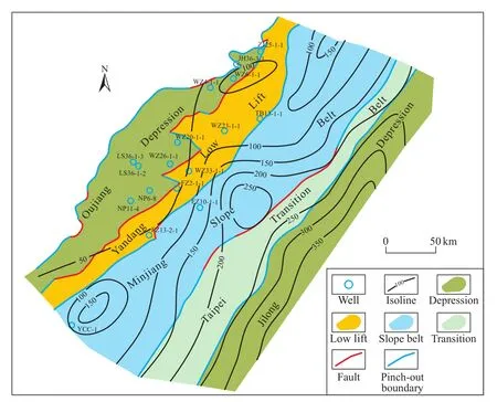
Fig. 6. Thickness map for Lower Cretaceous source rocks in the southeastern East China Sea continental shelf (with the base map being the Mesozoic tectonic regionalization map).
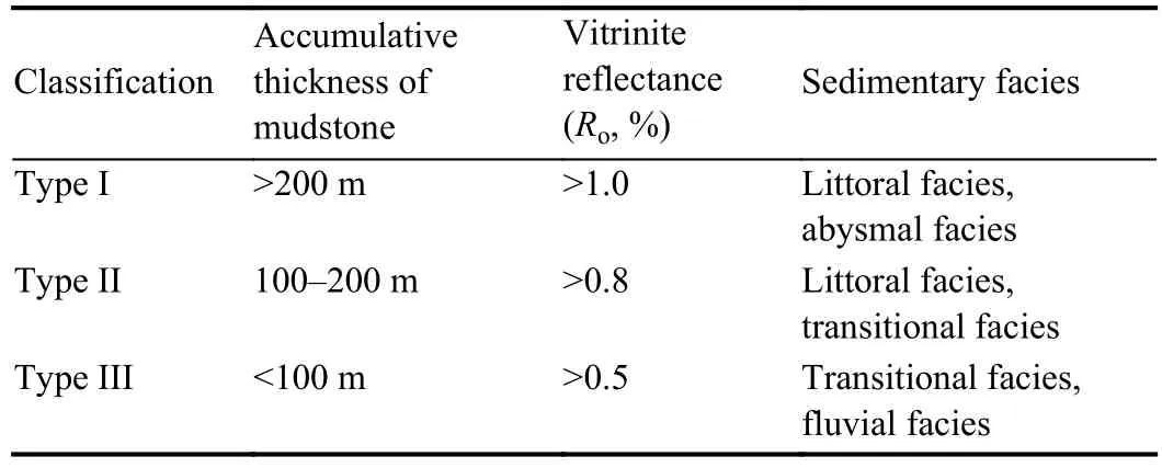
Table 2. Classification and evaluation criteria for Lower Cretaceous source rocks in the southeastern East China Sea continental shelf.
As can be seen from Fig. 7, the type I hydrocarbongenerating area is the hydrocarbon-generating center in the study area and the accumulative thickness of dark mudstone is>200 m withRo being >1.0%. The corresponding lithology is littoral dark mudstone, coal seam, and deep-sea dark mudstone, which are mainly distributed in the middle to southern part of the Minjiang slope belt, the middle to southern part of the Taipei transmission belt, and the middle to southern part of the Jilong Depression.

Fig. 7. Classification and evaluation map for Lower Cretaceous source rocks in the southeastern East China Sea continental shelf (with the base map being the Mesozoic tectonic regionalization map).
The type II hydrocarbon-generating area has good hydrocarbon-generating capacity with an accumulative thickness of dark mudstone ranging from 100 m to 200 m andRo being >0.8%. The corresponding lithology types are coastal facies and transitional marine facies dark mudstone and coal seam, which are mainly distributed in the northeastern part of the Minjiang slope belt, locally in the northern part, and in the northern part of the Taipei transmission belt. This type is relatively scattered in the study area.
The type III hydrocarbon-generating area has the worst hydrocarbon-generating capacity with an accumulative thickness of dark mudstone of <100 m andRo > 0.5%, which generally enterred or exceeded the early maturation stage. The corresponding lithology is marine-continental transitional facies and fluvial facies dark mudstone and coal seam, mainly distributed in the southern and northeastern Oujiang Depression, the Yandang Low Lift, and the northern Minjiang slope belt.
5. Conclusions
(i) The lithology of Mesozoic source rocks in the southeastern East China Sea continental shelf is mainly mudstone and coal measures. The Middle-Lower Jurassic source rocks are mainly shallow marine dark mudstone and transitional marine coal measures with the highest organic matter abundance, and these are the most important source rocks in the study area.
(ii) The kerogen type of Mesozoic source rocks in the southeastern East China Sea continental shelf is mainly type III, and the organic matter type is mainly humic. The source rocks have generally entered a mature stage.
(iii) The Mesozoic source rocks in the southeastern East China Sea continental shelf can be divided into three types.From northwest to southeast, the total thickness of the source rocks becomes thicker gradually, and the quality of the source rocks improves. The Jilong Depression in the southeastern part of the study area is the hydrocarbon-generation center of the Mesozoic source rocks.
Acknowledgement
This study was financially supported by Geological Survey Program of China Geological Survey (DD20160137,DD20190205, DD20190208), and the National Natural Science Foundation of China (41606079). The authors thank anonymous reviewers and Dr. Hao Ziguo and Dr. Yang Yan,who gave many constructive suggestions on the manuscript.

- China Geology的其它文章
- A sand-production control system for gas production from clayey silt hydrate reservoirs
- Two types of uranium mineralization in Gulcheru quartzite: Fracture-controlled in Ambakapalle area and litho-controlled in Tummalapalle area, Cuddapah Basin, Andhra Pradesh, India
- Redefinition of Early Mesoproterozoic (1800-1600 Ma) stratigraphy in the northern Kongling area, China: The nucleus of Yangtze Craton and its tectonic significance
- Comparison of detrital mineral compositions between stream sediments of the Yangtze River (Changjiang) and the Yellow River (Huanghe) and their provenance implication
- Stretching correction for amplitude-preserving vector wavefield reverse-time migration
- Analysis of formation and slope stability in Caofeidian Channel in Bohai Bay