城市的间隙建筑
——基础设施下方弃置空间的再利用
2021-04-27 08:07古斯塔夫安布罗西尼GustavoAmbrosini
世界建筑 2021年4期
古斯塔夫·安布罗西尼/Gustavo Ambrosini
黄华青 译/Translated by HUANG Huaqing
“高速公路可能会切断重要的视觉及符号联系:破坏优美的景观,或是切断区域之间的心理可达性,如同在观感上打断一条习惯性线路或是某种连续性活动……我们可以采用多种策略将其破环程度降至最低:控制高架桥的高度,或是重新链接从路面上方或下方穿过的结构、活动以及通道”[1]。
重型交通基础设施叠加在城市形态之上,形成了一种最容易被忽视的城市空间类型:即城镇的高架高速公路、地铁及铁路线路下方未被充分利用或被浪费的区域。这些空间对城市使用者很不友好。它们代表了两种尺度之间的转变:一边是人的尺度,另一边是“空降”在场地上的大型混凝土或钢铁构筑物的尺度。这些空间常被认为是衰败之地,突如其来的黑暗和不间断的噪音令人感到不安、压抑乃至焦虑。它们是城市肌理中将街区或景观分割的切口。
因此,当今城市面临的挑战之一即为如何利用和管理基础设施下方的公共空间。换言之,即如何真正修复这些空间——不仅是从美学角度,还要将其转化为有价值的社区资产。
1 分离/互动
如今,交通基础设施与城市之间的关系似乎受到一种分离逻辑的统摄:基础设施基于工程和道路系统的效能准则,建立并传达其作为自治空间的属性。道路功能维度从整个城市设计范畴中的分离可追溯至20 世纪初,当时运输和交通被作为“独立”科学学科而设立。
从这个意义上说,高架道路或铁路仅被视为一种依赖自持的原则、由极为有限的建筑语汇库所规约的技术性构筑物。大多数情况下,其形式来自于交通流理论、横纵面校准、横截面和交叉道口的几何构型。但也关乎弯矩与挠度—跨度关系、预制与预应力技术、施工与维护理念等。因此,在对交通网络进行改造干预时,它们往往被认为是一种无异于水力学原理的简单更新,从而失去了自身的表现性、象征性和典型性力量。
此外,现代主义运动形成的城市规划理念恰恰也遵循了这种分离原则,表现在对工作、居住、休闲和交通四大关键职能的定义中:根据功能主义城市规划原则,交通系统的自治性反映了都市机体的抽象功能性理念,这种功能性基于车辆交通、建筑朝向以及土地的自由使用。众所周知,这条路径受到了极大的重视。正如勒·柯布西耶曾写到的,传统的城市街道——通路——是难以忍受的:他曾公开争辩卡米洛·西特在1889 年出版的《城市设计》一书中提出的关于“中世纪城市中异规且曲折的街道的空间及表现潜力”的观点,嘲讽地将其定义为“驮驴之路”[2-3]。
值得一提的是,在勒·柯布西耶的作品中,道路的意义呈现出一种矛盾特征。在巴黎瓦赞规划中,道路的形式存在消隐了,而削弱为一种交通流:人们可以在“宽敞的路面上行驶,道路表面恰当地划分为机动车道和步行道”,也可以在“宽敞的公园里散步,远离公路的嘈杂声”[4]。相反,在他为一些南美城市和阿尔及尔所做的规划中,道路的意义发生了转变:作为在更大范围内出现的一种形态,道路在城市的秩序系统中被重新定位。类高架桥结构支撑起几公里长的连续高架路,契合城市的地理尺度,同时也是可满足居住及办公功能的巨构物。勒·柯布西耶在1929 年蒙得维的亚和圣保罗方案中勾勒出的中轴线结构,及1932 年里约热内卢方案和1933 年阿尔及尔方案中穿越景观的蜿蜒巨构,均是从鸟瞰视角规划项目的结果。这些构筑物相互交叠,同时又从所在环境抽离。现存的城市肌理被削弱为一个抽象的背景。几乎成为悖论的是,在他重塑可居住的高架桥这样一个强有力形态时,竟没有考虑人们如何真正使用基础设施下方的空间。即使是在最广为人知的“炮弹计划”草图中,尽管他近距离描绘了基础设施下方的可居住空间,却也没有刻意呈现该空间与地面的关系,只见一些仿佛悬浮在景观之上的阳台。
1960 年代,诸多项目在这样的“高架桥”式城市愿景下孕育而生,构想着通过建造超级巨构以塑造大都市的尺度。但在同一时期,多个研究领域中均出现了反对将道路分离的声音,他们希望强化道路是连接人类活动的途径这一理念,关注人对基础设施景观的感知。
诸多研究中的方向之一,是源于英国杂志《建筑评论》所呈现的文化途径。其中,西尔维娅·克洛所作的《道路的景观》(1960 年)一文,表明景观设计师的工作范围已从传统的公园和花园扩展到了流动性空间的尺度:这一趋势不仅关注如何在不破坏环境的情况下置入基础设施,也注重如何塑造基础设施自身的形象及造型特征[5-7]。另一发展趋势来自麻省理工学院和哈佛大学的城市研究联合中心,他们重点研究交通基础设施使用过程中的视觉及感知层面:旨在理解基础设施的规模和技术如何重塑环境中的象征性及表征性结构。出于将观察者所接收的新视觉材料重新组织的意图,他们利用视觉形式感知的理论,建立了与运动相关的感知性导则[8-10]。
2 图像
除学术文献之外,或许有必要分析几个现实案例,帮助我们更好地理解与基础设施“之下”和“之中”的空间相关的形象化潜能,并指出几个关键话题。

1 墨西哥城起义者广场,萨尔瓦多·奥特加,1969(摄影:古斯塔夫·安布罗西尼)/Plaza de los Insurgentes, Mexico City,Salvador Ortega, 1969 (Photo: Gustavo Ambrosini)
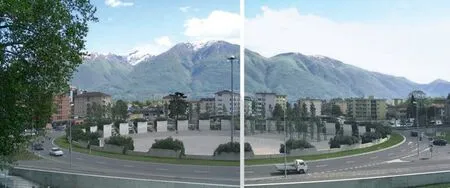
2 洛迦诺公路环岛,奥雷里奥·加尔菲蒂,2001(摄影:古斯塔夫·安布罗西尼)/Locarno roundabout, Aurelio Galfetti,2001 (Photo: Gustavo Ambrosini)
2.1 宜居性:墨西哥城起义者广场
1969 年,随着地铁线路的建造,城市近中心区的一个主要道路枢纽经历了彻底的改造和转型,成为一组立交桥,解放了大面积步行空间(图1)。由建筑师萨尔瓦多·奥特加设计的这个项目使得在基础设施下安置商店、酒吧、餐厅和公共服务成为可能,这些设施将朝向内部的步行区域开放:这是一片生机勃勃的现实绿洲,密布着休息座椅、街边摊贩和树木。地铁站位于并不中心的位置,外围环绕一道曲墙,墙上点缀镂空的混凝土砌块,每个空隙间皆镶嵌着来自玛雅文化象形刻版中的图样。地铁站是人流汇聚之处,但所有活动都被安置于立交环岛之下,因此道路才是真正的空间塑造者;然而,车辆交通并未干扰这里的活动,因为它完全被隐藏在一道清水混凝土护墙背后,墙上装饰了彩绘的护栏。这道护墙持续彰显着道路环岛的存在,同时也扮演着广场“立面”的对应角色。最引人注目的形象并不来自周遭建筑,而是由脚手架结构高高悬挂起来的巨型广告牌,形成一道由层层叠叠的彩色亮板构筑的风景。
2.2 标志性:洛迦诺公路环岛
这座由建筑师奥雷里奥·加尔菲蒂设计的环岛,建于2001 年,标志了这座城市的高速出口(图2)。设计意图是将一处严格意义上的技术设施转变为一处水平性的地标——它应契合基础设施的尺度,能够长期作为这座城市的“门户”。同时,地段下挖4m 以承载公共及休闲活动(国际电影节亦在众多活动之列),并提供不同城市区域之间的步行连接。内部墙体是由清水混凝土曲面隔断组成的,按照高低错落的交替韵律布置。这些要素不仅起到隔音作用,同时也作为绿植的生长地:这一混凝土边界由此成为一个具有厚度的空间元素,由规律的虚实序列构成,其中的绿植面向场地内部盛放倾展。这座新“广场”的极少主义立面构筑起一座垂直花园,它表征了基础设施的人工性,同时从中建立起一种独特的表现性语言。这道混凝土环墙就像是内侧环岛边缘道路的褶皱。这一道锯齿形的环墙让公路上的车行者亦可半遮半掩地瞥见内部空间;同时,它也增强了混凝土这种道路建设典型材料的柔性。该项目强化了这一场所作为高速出口的价值,提出了一种利用基础设施素材来生成新建筑语言的形象逻辑。
2.3 再自然化:巴塞罗那特立尼塔公园
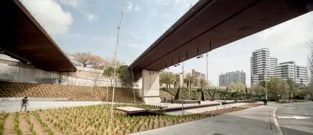
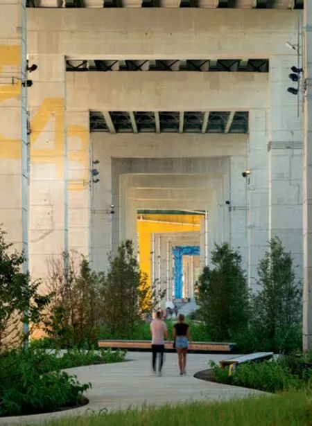
这座公园于1992 年由恩里克·巴特和胡安·洛瓦设计,位于一个大型交通枢纽——两条高速路、城市环路、铁路和地铁线在此交汇(图3)。公园设计为一个同质化的整体,植栽、水体、地形、公共空间和设施都是其整体的一部分。项目从将高速公路部分遮蔽起来开始——通过一个新建停车场和大型架空平台将周边社区连接起来——一系列退台将不同要素组织起来,其中亦容纳了体育设施;这条坡道通往公园的核心区,紧靠一片半圆形水池。在这个案例中,基础设施的环形结构并未被隐藏,而是成为场所地形塑造的基础;公园中的所有元素都顺着这一曲线形式来安排。大片树丛和水体随之强化了这一基本形式,同时又消解了公路的重量感。场所的尺度由植物韵律界定,提升了本地植物种类(柏树、白杨、悬铃木或果树),并由高度接近公路的山体所强调出来:在此,视线被成排的白杨引导上升,白杨树丛围合而成的柔和曲面也可作为高速公路的屏障。由此,基础设施成为塑造场所、为新型社会空间赋形的元素,重新将自然和地形引入城市。
这些案例展现了基础设施的建设如何强烈地与一种城市空间使用观念相关联;但它们也可以为当下某些情境提供诠释——即除了关注基础设施的新建,更主要的问题似乎是寻求现存基础设施再利用的策略。
城市转型的现象早在1980 年代的欧洲就已浮现在学术讨论中——大片工业用地遭到闲置、土地消耗亟需限制、基础设施老化废弃,这极大吸引了人们对于城市边缘或冗余区域的再利用问题的关注。诸如再利用、再开发、回收利用这样的词汇,证实了一个如今已在欧洲文化语境下完成的范式转型,即从基于“新”的概念,转而认可一个持续更新现有材料的过程。由此,即便是在土地开发过程中通常被视为废料之物——无论是基础设施还是弃用区域——都可以成为更新项目的契机:它们借助特定的行动,通常是自下而上的路径操作,能够激活城市或区域中的废弃机体[11]。
分离和冲突——体现在基础设施尺度与人体尺度的关系中——证实了城市作为一个由碎片组成的整体的理念,需要一种间隙式的介入过程。“间隙”这一概念源于马丁·布伯的哲学话语,最早于1950年代由阿尔多·凡·艾克引入,用来定义在社区空间和概念领域之间互动作用的中间区域[12]。对凡·艾克而言,对间隙的关注意味着调动两个相邻的元素,由此达到一种互惠的成效:并不是常见的非此即彼,而是借助其彼此间的张力来创造一个作为第三空间的缝隙。这便是赫曼·赫兹伯格定义为“限阈”之物:“具有不同领域特征的区域之间的过渡和连接,一个自持之所,它在本质上构建了不同秩序的区域之间会面和对话的特定情境”[13]。
3 加密/开放:案例研究和策略
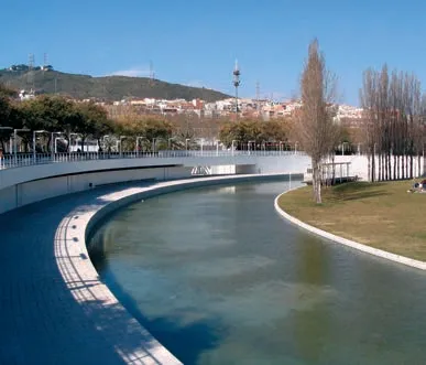
3 特立尼塔公园,巴塞罗那,恩里克·巴特,胡安·洛瓦,1990-1993(摄影:古斯塔夫·安布罗西尼)/Trinitat Park, Barcelona, Enric Battle, Joan Roig, 1990-1993 (Photo:Gustavo Ambrosini)
"An expressway may break off important visual and symbolic connections: destroy a fine view, or shut off psychological access between one section and another, as by visually disrupting a customary line of approach, or a continuous linkage of activity…Various devices may be used to minimise the damage:manipulating the elevation of the roadway, or reconnecting structures, activities, and pathways over or under the roadway"[1].
The superimposition of heavy transportation infrastructures on the form of cities produces one of the most common types of neglected urban space:the underutilised or wasted areas below elevated freeways, subways and railway lines inside towns.These spaces are quite unwelcoming for city users.They represent a shift between the human scale and the scale of the large concrete or iron structures"landing" on the ground.They are often perceived as places of decay, where sudden darkness and incessant noise cause feelings of unease and oppressiveness,when not anxiety.They are cuts in the city's pattern dividing neighbourhoods or landscapes.
Therefore, one of the challenges today facing cities is to take charge of public spaces at ground level below infrastructures.In other words, how to really recover them, not only from the aesthetic point of view, in order to transform them into valuable community assets.
1 Separate/Interact
Nowadays the relationship between the transport infrastructure and the city seems to be dominated by the logic of separateness: the infrastructure establishes and communicates its own nature as an autonomous space, derived by engineering and road system efficiency criteria.The isolation of the functional dimension of the road from the overall design of the city dates back to the beginning of the 20th century, when "autonomous"scientific disciplines regarding transport and traffic arose.
In this sense, an elevated road or a railway is intended as mere technical structure that depends on self-referential discipline, regulated by a limited syntax coming from building repertoires.The form derives in most cases from traffic flow theories,horizontal and vertical alignments, cross-section and intersections geometries.But also from bending moment and deflection-span relationship, precast and pre-stressed techniques, construction and maintenance concepts.Hence, when modifying interventions of the transport networks occur, they are often supposed to be a simple update, assimilated to the principles of hydraulics and consequently deprived of their own expressive, symbolic and representative capacity.
Furthermore, it is precisely the conception of urban planning developed within the Modern Movement that follows a logic of separateness, when defining the four key functions – work, residence,recreation and transport: the autonomy of the transport system, as established in the Functional City principles, reflects the idea of an abstract functionality of the metropolitan body, based on vehicular traffic, on the orientation of buildings and on the free land use.As it is well known, this approach had a great emphasis, for example, in the writings of Le Corbusier, in which the traditional city street – the rue corridor – was considered no longer tolerable: he openly argued with the approach that Camillo Sitte proposed in his 1889 book Der Städtebau, about the spatial and expressive potential of irregular and curving streets in Medieval cities, mockingly defining them as pack donkey's way (the "chemin des âne")[2-3].
It is interesting to remark that in the works of Le Corbusier the meaning of the road takes on an ambivalent character.In Plan Voisin it disappears as a form itself and is reduced to a traffic flow canal:people were intended to drive along "roadways of ample dimensions and a proper division of their surface as between motor-transport and footpassengers" and walk "among spacious parks remote from the busy hum of the highway"[4].On the contrary in the plans for some South American towns and for Algiers it undergoes a shift in its meaning:it appears as being repositioned in the ordering system of the city by acting as a form at a larger scale.Viaduct-like structures perform as continuous elevated roads several kilometres long, in relation to the geographical dimension of the city, and in the meantime as giant buildings that host housing and offices.The straight axes sketched in the proposals for Montevideo and São Paulo in 1929 as well as the serpentine mega-structures winding through the landscape of the plans for Rio de Janeiro (1932) and Algiers (1933) are the result of a project conducted from a bird's eye view, which overlaps them and at the same time detaches them from the context.The existing city's patterns are relegated to an abstract background.It almost seems a paradox that the reinvention of such a powerful image, the inhabited viaduct, does not take into account how people would really use the space underneath the infrastructure.Even the most famous sketch of the Plan Obus that closely represents the inhabited spaces below the infrastructure does not intentionally represent the relationship with the ground, leaving the balconies as if suspended above the landscape.
In the 1960s many projects came up from that"viaduct" city vision, envisaging the construction of large mega-structural forms as a generating element of the metropolitan scale.But in the same period,a reaction against that condition of separateness of the road emerged in several fields of study, aiming at enhancing the idea of a road as a mean of connection of human activities, which therefore focused on the human perception of the infrastructural landscapes.
One of these lines of research arose in the context of the cultural approach expressed by the British magazine Architectural Review.There were several contributions, such as The Landscape of Roads by Sylvia Crowe (1960), which showed a widening of the landscape architect's traditional field of work – the park and the garden – to the scale of mobility spaces: this approach focused on how to insert the infrastructure without damage in the environment, but also how to give it its own physiognomy and figurative personality[5-7].Another trend developed from the studies of the Joint Centre for Urban Studies of the Massachusetts Institute of Technology and Harvard, focusing on the study of the visual and perceptive aspects in the use of traffic infrastructures: the purpose was to understand how the scale and the technologies of the infrastructures modify the symbolic and expressive structures of the environment.The intention of re-organising the new visual materials that are offered to an observer led to building an inventory of perceptual principles related to movement, making use of the theories on the perception of visual form[8-10].
2 Figures
Alongside the disciplinary literature, it may be useful to analyse some real cases that help us to better understand the figurative potential linked to the spaces "below" and "inside" the infrastructures,pointing out some key topics.
2.1 Liveability

4 铁路桥更新项目,苏黎世,2004-2010(摄影:拉尔夫·胡特)/Im Viadukt, Zurich, 2004-2010 (Photo: Ralph Hut)

5 黄金町中心,横滨,2012(摄影:工作站)/Koganecho Centre, Yokohama, 2012 (Photo: Workstation)

6 生活方式百货商店,福尔堡,1998-2002(摄影:汉斯·帕提斯)/Life Style Department Store, Voorburg, 1998-2002(Photo: Hans Pattist)
以下几个案例的综述将纵览多种路径和策略——从室外休闲空间到容纳服务设施及文化活动的新体量。在某些案例中,这些策略的目的是提升空间密度,嵌入功能和体量,提出与基础设施相抗衡的形式和材质,在完善与地面的连接的同时,将它们从抬高的道路及视线中脱离开来,以确认其自身的材料自治性。相反,其他的案例则呈现了一个清空和重塑场地的过程,将自然重新带回城市,开辟了顺沿或穿越基础设施的路径以作为城市的慢行空间,加强它们作为带顶的室外空间的独特属性。
加密的路径可以借助多种表达性策略来实现。
2004 年,EM2N 建 筑 事 务 所 与Zulauf Seippel Schweingruber 景观建筑事务所赢得了一项建筑竞赛,是针对瑞士苏黎世一座19 世纪铁路桥遗产的修复更新(图4),这座桥曾割裂了一片成熟的住宅区和一片老工业区。设计挑战是如何将一座受保护的遗产重新纳入城市系统的一部分来使用。它由两条交汇轨道组成:较低的一条轨道被改造为一条自行车及人行道,较高的一条则继续用作铁路。在两条轨道之间的三角区域建造了一座新建筑,以容纳大约30 间商店、小餐馆和一家杂货市场。这座建筑建于2010 年,它是一组由三元乙丙橡胶覆盖的体量,分成一系列上下起伏、拥有圆形天窗的单体建筑;支撑体系采用预制木架结构,一体化的胶合板木格架体系固定在两层钢格栅构件之间。屋顶翻折的韵律顺应桥梁拱券的节奏,视觉上仿佛连接了两座高架桥:新建筑就像是拱券之间的带状商店,刻意的形式约束凸显出宏伟的石柱结构。这样的建筑选择表达出高架桥模棱两可的属性:既是一座超大尺度的连接器,又是一座线性的公共建筑。
日本横滨的黄金町历史上曾是非法犯罪活动的集聚地,在21 世纪最初10 年的一项城市更新计划中经历了深度转型(图5)。2008 年以来,黄金町区域管理中心、一家当地非营利性组织、横滨市政府以及九州岛铁路公司开启了一项合作,试图以公共事件及艺术活动为契机,推动社会的再发展。2012 年,一片大约100m 长的铁路桥下土地被彻底更新,容纳了一家画廊、一间咖啡厅、一座图书馆、一间艺术家工作室、一处会面场所,还有一块拥有阶梯座位的带顶广场。设计工作委托了7 家建筑事务所共同完成,包括Contemporaries, Studio 2A, SALHAUS, Workstation, Koizumi Atelier,Sogabe Laboratory-Matidesign, Nishikura Architectural Design Office:每家都借助不同的形式语言以及木材、玻璃和素混凝土等简单材料,与现存的厚重混凝土柱建立了各自的对话。最终的设计结果呈现出一种折衷的多样性,当人们漫步其间,能够激发一种充满活力的感受;同时,洗练的建筑体量维持了整体上的感知一致性,吸引社区居民来使用这些失而复得的空间。
在荷兰沃尔堡,NIO 建筑事务所为“生活方式”百货商店设计了一座新建筑,建筑位于一座公路铁路双线高架桥的下方(图6)。建筑体量占据了高架桥下约50m 的全部进深空间,并在端部悬挑至室外。建筑侧面采用大跨度的不规则拱结构,表面覆盖小块玻璃马赛克:在南端,建筑结构凸出至高架桥外,悬挑在公园前的一块步行区域上,形成了巨大的入口雨棚。建筑室内是一个大空间,采用白色天花和黑杂色混凝土地面,其中陈列着五彩斑斓的各品牌服装、鞋履、配饰和化妆品。这是一个弯曲的、近似动物形态的形式,与它并置的是高架桥的笔直线形:厚重的拱形体量几乎是纪念性的,它也在体量上与上方桥梁的巨大尺度形成对比。同时,圆润的外形和绿色瓷砖的多种细腻色差——配合橱窗的垂直木分隔——使它成为一个“柔软”的客体,具有极大的触觉表现力,陪伴着路过的行人。

7 斯坦尼加S2剧场,日利纳市,2009(图片来源:斯坦尼加档案馆)/S2 Theatre Truc Spherique, Stanica Zilina, 2009(Source: Stanica archive)
Plaza de los Insurgentes, Mexico City.In 1969,during the construction of the metro line, one of the intersection of the main avenues in a semi-central area of the city was completely remodelled and transformed into an elevated road junction that freed up a large space for the pedestrians.The project by architect Salvador Ortega made it possible to locate shops, bars, restaurants and public services under the infrastructure, open towards the inner pedestrian area: this is a real oasis of liveliness, with crowded benches, street vendors and some trees.The subway station is located in a non-central position and is characterised by a curved wall lined with concrete hollowed-out blocks, each one containing pictograms inspired by the stone carved glyph boards of the Maya culture.The station is a hub of pedestrian flows,but the activities are all placed under the avenue ring,so it is the road here that really shapes the space;however, the vehicular traffic does not disturb its activities, as it is almost completely hidden by the exposed concrete parapet crowned by a painted guard rail.That parapet is the continuous mark revealing the presence of the road ring and acts as a counterpoint to the "façades" of the square.The prevailing image is not given by the architecture of the surrounding buildings, but by the giant advertising signs hanging on them with their structures, that form a scenery of overlapping coloured and shining surfaces.
2.2 Iconicity
Locarno highway roundabout.The roundabout designed by architect Aurelio Galfetti, completed in 2001, marks the arrival point of the motorway in the city.The intent was to transform a strictly technical element into a horizontal landmark – related to the scale of the infrastructure – capable of perceptually acting as a "door" to the city.At the same time, the site is excavated 4 metres lower than the road level to host public and entertainment activities (among various events, the International Film Festival) and provides a pedestrian connection between different urban areas.The internal walls are made up of curved partitions in exposed reinforced concrete, arranged according to an alternate sequence of high and low walls.These elements constitute a noise protection wall but at the same time they act as a support for the vegetation: the concrete edge becomes a thick element, consisting of a regular sequence of solids and voids, which incorporates the plants, shows them outwards and pours them out into the inner space.The minimal language of the façade of this new "square" constitutes a vertical garden which expresses the artificiality of the infrastructure and builds a specific expressive language from this.It is as if this concrete profile constituted a corrugation of the road along the edge of the inner ring.A builtup crenellated wall protects but allows motorists to glimpse the interior space; at the same time, it enhances the plasticity of concrete, a material typical of road construction.The project emphasises the value of the place as the arrival point of the highway,proposing a figurative logic that uses the materials of the infrastructure to generate a new syntax.
2.3 Re-naturalisation
Trinitat Park, Barcelona.The park was built in 1992 on a project by Enric Battle and Joan Roig and is located within a large circular interchange where two motorways, the city's ring road, the railway and the subway converge.The park is designed as a homogeneous entity, in which vegetation,water, orography, public spaces and facilities are part of a whole.Starting from the covering of a part of motorway – which allows to connect the neighbouring district through a new parking lot and a large terrace-bridge – a series of terraces arranges the various essences, hosting sports services; this sloping course leads to the heart of the park, bordered by a semi-circular water basin.In this case, the circular sign of the infrastructure is not hidden, but rather constitutes the foundation trace that establishes the topography of the place; all the elements of the park are put in place following this curvilinear pattern.The large plant masses and the water system consequently underline this foundation mark, counterbalancing at the same time the visual weight of the roads.The scale of the place is marked by vegetation rhythms,enhancing local plant species (cypress, poplar, plane,or fruit trees) and emphasised by the hill that reaches the level of the highways: here the view is directed upwards by the rows of poplar trees creating gentle arching lines and acting as screen for the freeway.Infrastructure can thus be the element that shapes the place and gives form to new social spaces,reintroducing nature and orography into the city.
These are examples in which the construction of the infrastructure was strongly connected to a concept regarding the use of urban space; but they can offer some interpretations in present time when,rather than the construction of new infrastructures,the main question seems to be the setting up of strategies for recycling the existing ones.
The phenomena of urban transformation that were already emerging in the debate of the eighties in Europe – the dismissing of vast industrial areas, the need to limit land consumption, the obsolescence of infrastructures – had progressively drawn attention to rehabilitation issues envisaged for marginal or residual areas of the city.Terms such as reuse, redevelopment, recycling testify to the now completed paradigm mutation, in the context of European culture, from a concept based on the idea of the "new", to an awareness of the process of continuously remodelling existing materials.In this sense, even what is commonly considered the waste of a territorial development process – whether they are infrastructures or abandoned areas – could become an opportunity for regeneration projects: by means of specific actions, often carried out according to bottom-up interventions, able to innervate the obsolete body of cities and territories[11].
Separateness and conflict, expressed by the relationship between the infrastructure scale and the human scale, certify the idea of the city as a complex made up of fragments that requires an in-betweening process.The "in-between" concept, taken from Martin Buber's philosophy of dialogue, was introduced by Aldo van Eyck in the 1950s, to define intermediate zones that interact between communicating spatial and conceptual areas[12].For Van Eyck, to drive attention to the in-between means employing two elements in conjunction so that to obtain a reciprocal effect: it is not the prevalence of one over the other,but their mutual tensioning to create a gap as a third space.It is what Herman Hertzberger defined with the term "threshold": "the transition and connection between areas with divergent territorial claims and,as a place in its own right, it constitutes, essentially,the special condition for the meeting and dialogue between areas of different orders"[13].
3 Densify / Open: Case Studies and Strategies
A review of several projects offers an overlook of several approaches and strategies, from outdoor leisure spaces to new volumes for facilities and cultural activities.In some cases, these are strategies that densify the space, adding functions and volumes,proposing shapes and materials that counterpoint the infrastructure, complete its connection with the ground but at the same time detach themselves from the elevated track from the perceptual point of view,affirming their own material autonomy.In other cases, it is, on the contrary, a process of emptying and re-modelling the ground, which brings nature back into the city, which promotes paths along or through the infrastructure, as places of slow journey within urban space, enhancing its uniqueness of covered exterior space.
The densifying approach can be carried out by means of multiple expressive strategies.
最后是斯洛伐克日利纳市的斯坦尼加文化中心S2 剧场,这个案例绝佳地表达了将高架路下方的消极空间转化的回收策略(图7)。非盈利组织“Truc Spherique NGO”此前就曾将临近一座仍在运行的火车站更新植入了多媒体的文化活动。2009 年,该组织建造了一座用于戏剧表演和公共活动的社区空间,建筑是由120 名志愿者在3 个月内建成的,由土草建造体系专家汤姆·莱文指导。这两座相交的圆柱体嵌入高架路之下,墙体由3000 个啤酒箱组成,填充物是混入干草的粘土;建筑入口是嵌入圆柱体基础部分的一个蓝色集装箱。建造过程同时是一项完全采取可回收地方材料及废品的实验性工程,无需任何复杂技术。不幸的是,这座建筑在10年后因火灾严重损毁。
另一类建筑策略试图将场地重塑为宜居的城市通道,也提出了多样化的休闲功能。
在美国的某些实验案例中,这类通常在城市扩张中残剩的弃置空间的再利用,最先是由一些面向滑板、自行车等青年非主流运动的自组织团体发起的。例如,波特兰的伯恩塞德滑板公园(图8),是在1990 年由一群滑板青年在未经允许的情况下建造的,他们“重新收复”了这片曾经为瘾君子和卖淫者所统治的区域。项目一开始只需将混凝土浇筑在墙体边以形成堤岸,然后慢慢塑造出现代滑板公园所需的隆起、下凹、塔尖、垂面等地形特征。这个公园未从城市官方得到任何赞助,但借助着志愿者和捐献者的付出,它成为一个名副其实的公共空间,得到当地人的广泛接受和欢迎,被视为城市景观活力的杰出案例。
西雅图的“I-5 柱廊”项目也经历了一个类似的转型过程。20 世纪之交,这块位于市中心北部I-5 高速公路下方坡地的废弃区域,吸引了一个当地自行车社群的注意;“乡野自行车越野俱乐部”于是被引进至此,借助资助、赞助和捐助建造起一座自行车公园,于2008 年建成。在高速公路巨柱之间蛇行穿梭着自行车道、越野道以及遛狗区,如今已成为自行车运动的热门场地,吸引着专业运动员、初学者和家庭出行者。
滑板或自行车运动者对空间的使用与常规的城市使用之间的潜在矛盾亦不可低估:空间的塑造必须让滑板的空中腾跃等最具“攻击性的活动”与儿童老人等使用者的需求毫无危险地共存。SCOB 建筑与景观事务所在巴塞罗那设计的两个项目,就致力于将滑板公园塑造为城市街道的公共场所,与城市景观紧密互动。
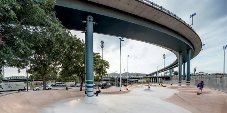
奥莱亚—夸德拉多城市运动公园被设计为一个滑板广场,提供了一处基础设施高架下方的连续公共场地(图9)。直线元素根据某种分段式肌理而弯折,伴随着景观的重整,塑造出倾斜的人工及自然表面。高差变化和连续坡道加强了场所的连续感,滑板的要素序列与植物相融合:墙体、倾斜表面、台阶、台地、平台、座椅、扶手等皆由混凝土和耐候钢板建造,共享同一种语言。
9 奥莱亚—夸德拉多城市运动公园,巴塞罗那,2014(摄影:安德瑞亚·古拉)/Aureà Cuadrado Urban Sports Park,Barcelona, 2014 (Photo: Adrià Goula)
10 巴罗—德韦维尔城市体育公园,巴塞罗那,2016(摄影:安德瑞亚·古拉)/Baró de Viver Sports Urban Park,Barcelona, 2016 (Photo: Adrià Goula)

8 伯恩塞德滑板公园,波特兰,1990(摄影:泰德·恩斯特·萨尔维塔)Burnside Skatepark, Portland, 1990 (Photo: Ted Ernst Sarvata)
In 2004, the bureau EM2N architects and Zulauf Seippel Schweingruber Landscape Architects won the architectural competition for the refurbishment of a XIX Century monumental train viaduct in Zurich,Switzerland, separating the developed residential area from the old industrial district.The challenge was to re-use a protected monument as part of the urban system.There were two converging tracks: the lower was transformed into a cycle-pedestrian path,the higher kept its railway use.In the triangle space between the rail tracks, a new building took place, in order to host around 30 shops and cafés and a market hall for groceries.It has been completed in 2010 as a folded volume covered with black EPDM rubber, made of a series of rising and falling segments punctuated by roof-light domes; the supporting framework is made of pre-fabricated timber panel elements with integrated glue-laminated timber brackets, clamped between steel lattice elements.The rhythm of the roof folds follows the rhythm of the arches and visually interlace the two viaducts: the new structures appear as band-like shopfronts between the arches,deliberately restrained so that to emphasise the giant stone pillars.The architectural choices express the ambivalent character of the viaduct: a large-scale connecting machine and a linear public building.
The district of Koganecho in Yokohama, Japan,historically devoted to illegal activities, was deeply transformed through an urban renewal plan in the first decade of the 21st century.Since 2008, a collaboration was started between Koganecho Area Management Centre, a local non-profit organisation,the City of Yokohama and the Keikyu railway company, in order to foster events and art activities as an opportunity for social re-development.In 2012,an about 100 metres stretch of land under a train overpass was completely transformed to host an art gallery, a café, a library, an artist's atelier, a meeting space and a covered piazza with stepped seats.The work was commissioned to seven architectural offices(Contemporaries, Studio 2A, SALHAUS, Workstation,Koizumi Atelier, Sogabe Laboratory-Matidesign,Nishikura Architectural Design Office): each of them has established their own dialogue with the concrete thick existing columns, by means of different shapes and simple materials – wood, glass, metal and pale concrete.The overall result expresses an eclectic multiplicity, generating a dynamic feeling as people walk along and through the complex; at the same time, the clean-cut volumes maintain an overall perceptual coherence, welcoming the community to utilise the regained space.
In Voorburg, the Netherlands, NIO Architecten designed a new building for the Life Style Department Store under a double viaduct carrying motorway and railway tracks (1998-2002).The volume occupies the entire depth of the viaduct, about 50 metres, and continues outside with curvilinear ends.The sides are made up of large irregular arches covered with small glass mosaic tiles: at the southern end, this structure literally juts out from the viaduct, overhanging a pedestrian area in front of a garden and forming a large entrance canopy.The interior is one large space with white ceilings and black-pigmented concrete floor, where colourful brands of clothing, shoes,accessories and cosmetics are displayed.It is a curved,nearly zoomorphic form, which is juxtaposed with the straight lines of the viaduct: the dimension of the thick arches, almost monumental, compare in scale with the large size of the bridge above.At the same time, the rounded profile and multiple green colour variations of the tiles – counterpointed by the vertical wooden partitions of the shop windows – make it a"soft" object, of great tactile expressiveness, which accompanies pedestrians as they pass.
Finally, the S2 theatre built for Stanica Cultural Centre in Zilina, Slovakia, represented an outstanding example of recycling strategies to convert inhospitable areas below the road overpass.The non-profit organization Truc Spherique NGO had previously regenerated a nearby still operating railway station for multi-media cultural activities.Then in 2009, this NGO set up the building of a community space for theatre and events through a collective work carried out by 120 volunteers in three months, following the teaching of Tom Rijven, an expert of working systems with clay and straw.Two intersecting cylinders, whose walls were made of three thousand beer crates, filled with straw mixed with clay, were inserted under the motorway bridge; the entrance was provided by a blue shipping container wedged at its base.The building process consisted of experimental work with fully recyclable local material and waste, that didn't need any kind of sophisticated technology.The structure was unfortunately seriously damaged by fire 10 years later.
The strategies aiming at the requalification of the ground as a liveable urban path propose multiple leisure functions.
In some experiences in the USA, the first step towards the reuse of these derelict spaces, considered leftovers in ordinary city growth, was taken by selforganised communities dedicated to youth and nonconventional sports, such as skateboarding or bike.The Burnside Skatepark in Portland, for instance,was created without permission in 1990 by a group of skaters that "re-conquered" an area once overrun with drug addicts and prostitutes.It started by simply pouring some concrete against a wall to make a bank,till reaching the modern skate-park features required as hips, pools, pyramids, and vertical sections.It received no funding from the city, but thanks to the commitment of volunteers and donors it has become a veritable public place, well established and accepted by the locals, perceived as an exemplary case of the vitality of the urban landscape.
The so-called I-5 Colonnade in Seattle underwent a similar transformation process.The dead zone located on a slope under the I-5 freeway north of downtown had drawn the attention of a community of local bikers at the turn of the past century; the Backcountry Bicycle Trails Club was then brought in to build a bike park thanks to grants, sponsorship deals and donations, which was completed in 2008.The winding series of bike paths, trails and an offleash area running under the high motorway columns is now a very popular place for bike activities, used both by expert free-riders and by beginners and families.
The potential conflicts in the use of space between skaters or bikers and the ordinary city users is not a matter to be underestimated: the space must be shaped so that the most "aggressive activities",such as jumping and twirling in the air with a skateboard, can coexist without danger with the needs of other users such as children or the elderly.Two realisations in Barcelona from SCOB Architecture& Landscape office aimed at the creation of skate parks as city street public areas, strictly interacting with the urban landscape.
Aureà Cuadrado Urban Sports Park (2014)is conceived as a skate square that provides a continuous public ground under some elevated infrastructure tracks.Straight lines bend according to a pattern of segments and accompany the modelling of the landscape, shaping inclined artificial and natural surfaces.Changes in level and retaining slopes strengthen the feeling of a continuous place,where the sequence of skate elements blends with vegetation: walls, inclined planes, stairs, steps,platforms, benches, handrails, made by concrete and Corten steel, share a common language.
巴罗—德韦维尔城市体育公园建在特立尼达公路枢纽东部的一块剩余区域(图10),它被铁道与现有公园分隔开来:在周边居民看来,这个弃置空间是不安全的,它是速度规则和公路交通尺度的直接结果。由于道路枢纽的存在,交织的大尺度曲线元素将空间切开,这也成为滑板道的几何构形的灵感来源。滑板者在不同的室内环道上滑行,伴随着车辆和基础设施的曲线运动,在某种程度上将后者融入体育运动实践。特定的元素——如所谓的“起伏道”“弯曲寿司盘”“鬣蜥尾”等,也被引入以塑造这座新滑板公园的个性特征。在这些项目中,诸多新元素的设计构建了一套独具识别性的特定视觉语言,同时处理了与基础设施及景观元素的互动关系:质地、图样、色彩共同形成一套与现存道路和植被相勾连的句法系统。它们不是分离的运动区域,而是街景的一部分,激发不同城市使用者之间的互动。
在更大尺度上,某些实验案例展现了高架基础设施下方场地的再利用如何促进了线性公园的形成,它们意图作为一种绿色基础设施,能够激活大范围的城市区域,支撑新的公共生活形式;同时,它们也印证了公私合作过程的复杂机制。
加拿大多伦多市正在进行一项再开发计划,面向的是加德纳高速公路下方1.6km 长的废弃土地,项目设计者是城市设计师肯·格林伯格与公共工程景观建筑事务所(图11)。设计方案的构思和形成经过了高强度的、环环相扣的多方咨询过程,参与者包括周边居民、潜在使用群体、多伦多城市理事会、项目支持者等,还特地成立了一个非盈利独立慈善机构“弯道守护者”来管理该项目的实施。长约600m 的第一阶段工程在2018 年完工。一条新的人行和自行车道穿梭在支撑高架桥的厚重混凝土梁柱序列之间;其中一些柱子高达15m,提供了纪念性的开放“房间”;其他一些柱子则界定出更亲近尺度的空间。高架桥之下的空间转型为一个由景观化的公园和公共艺术作品构筑的连续公共场地,提供了多样化事件与活动的灵活场地;而对坡地的重塑以及弃置泥土的再利用则创造出新的地形。这项共享的公共场地的新模式,为临近湖岸的多伦多市民提供了一处充满活力的聚集场地。
一个类似过程也发生在迈阿密。非盈利组织“桥下之友”与迈阿密戴德郡政府合作,提出一项计划以改造一段约16.09km 长的铁路轨道下方,485,622m2的未充分利用的空间。这段轨道是于1984 年投入使用的双轨高速铁路系统,穿过城市中心运行(图12)。詹姆斯—科纳—菲尔德景观设计事务所做了概念规划,设想了一条可持续、多模式廊道,以呈现南佛罗里达的艺术、文化和植被。第一阶段建设是北部一条0.8km 长的地段,名为“布里克尔后花园”,于2021 年2 月完工。其设计理念是作为一系列室外的“房间”,每个都有独一无二的个性:“河流厅”拥有欣赏迈阿密河的景观视野;“健身房”是由体育场地组成的休闲空间;“散步道”则是一条行人和自行车道,中途穿插面向社区的空间,如一块演出广场,还有一张15m 长的社区餐桌;“鸡蛋石厅”是一块拥有4 个蝴蝶花园的自然化区域。新的桥下空间被设计为一个连续的大尺度社区公园,同时也在其各个部分提供了一种态度统一却又适于各自地段的解决方案,以适应和反映独特的社区情境。
11 弯曲之路,多伦多,2018(摄影:尼克·勒胡斯)/The Bentway, Toronto, 2018 (Photo: Nic Lehoux)

12 桥下之友,迈阿密,2021(摄影:罗宾·希尔)/T he Underline, Miami, 2021 (Photo: Robin Hill)
4 结语
最后,这里必须引用一份由纽约公共空间设计信托与纽约市政府交通局联合开展的研究。研究的出发点是意识到,在纽约市共有数以万计未充分使用的公共空间,位于共1126.54km 长的高架路之下。基于此话题而开展的专门研究,试图理解如何通过回收利用高架交通基础设施相关的空间来提升社区韧性。研究报告发表于2015 年,题为《高架之下:收复空间,链接社区》,提供了此类空间转型利用的设计提案以及功能与政策建议:包括纽约市桥下土地的详细目录、地块物质环境的编目、不同场地的参与式工作坊、为具体地段定制的装置、基于文脉的设计以及功能设置的建议[14]。
总而言之,上述案例研究提供了针对基础设施沿线下方的未使用空间再开发的多种设计策略。原本废弃的场地、空置的土地、现代性的残余,如今都能经由意义的转换以吸引公众的注意,同时也是对城市居民群体的自发活化。因此,这类空间极其适合转变为会面相聚、社会交往和集体共享的场所。□
The Baró de Viver Sports Urban Park (2016) was built within a residuary area in the eastern part of Trinidad road junction, separated from the existing park by the railway line: it was an abandoned space that neighbours perceived as unsafe, a direct outcome of speed rules and motorway traffic scale.The presence of the highway junction, which cuts through the space with large intertwined curved gestures,served as inspiration for the general geometry of the skate track: skaters move by recreating different interior circuits, which accompany the curvilinear movement of cars and infrastructures, incorporating them, in a certain way, into sports practice.Particular elements – such as the so-called pump track, curved sushi plate, iguana tail – are introduced in order to give personality to the new skate park.In these projects the design of the many elements establishes a specific visual language, with its own identity, but which settles a mutual relationship with the elements of the infrastructure and the landscape: textures,patterns, colours generate a syntactic system connecting with the existing routes and vegetation.They are not separated sports areas but part of the streetscape, encouraging the interaction between different city users.
At a larger scale, some experiences show how the reuse of the ground under high infrastructure has been driven to the creation of linear parks, intended as green infrastructures able to innervate wide urban areas, supporting new forms of public life; they testify as well the complex set up of public-private partnerships processes.
In Toronto, Canada, a redevelopment process of a mile-long stretch of neglected land under the Gardiner Expressway is underway, according to the project of the urban designer Ken Greenberg and the landscape architecture firm Public Work.The design vision and the programming approach were developed through an intense and articulated phase of consultations with neighbours, potential user groups, City of Toronto boards, supporters, and the creation of a not-for-profit independent charity,Bentway Conservancy, in charge of carrying out the project.The first stretch of about 600 metres has been completed in 2018.A new pedestrian and bicycle trail runs between the dense series of supportive portals made by heavy concrete columns and beams; some of them reach the height of 15 metres, providing monumental open "rooms", others define more intimate spaces.The underside of the motorway is transformed as a continuous public ground made of landscaped gardens and public artworks, providing flexible spaces for a multiplicity of events and activities; the remodelling of the slopes, reusing displaced soil, establishes a new topography.This new model of shared public terrain offers a vibrant gathering place for Toronto's population close to the lakeshore.
A similar process is ongoing in Miami.The non-profit association Friends of the Underline, in partnership with Miami-Dade County, envisaged the programme for the transformation of 120 acres of underutilised space below a 10-mile portion of Metrorail, a dual track rapid-transit system that opened in 1984 and runs through the city's urban core.James Corner Field Operations designed a framework plan envisioning a sustainable multimodal corridor inspired by the arts, culture, and flora of South Florida.The first phase regarded a halfmile stretch in the northern part, named Brickell Backyard, and was completed in February 2021.It has been conceived as a series of outdoor "rooms",each one with its own identity: the River Room with views of the Miami River; the Gym, a recreation space with sports courts; the Promenade, a walkway with pedestrian and bicycle paths punctuated by community-oriented spaces, such as a performance plaza and a 50-foot-long communal table; the Oolite Room, a naturalised area with four butterfly garden.The new Underline is designed as a continuous large scale neighbourhood park, offering in each section, at the same time, a common attitude and a site-specific solution able to adapt and reflect specific community issues.
4 Conclusion
In the end, a study by New York Design Trust for Public Space, together with the NYC Department of Transportation, must be cited.The starting point was the awareness that, in the city of New York, hundreds of thousands square metres of underutilised public space are lying under 700 miles of elevated infrastructures: the carrying out of specific research on this topic was aimed at understanding how to increase the resiliency of neighbourhoods by reclaiming the spaces associated with elevated transportation infrastructure.The study released in 2015, Under the Elevated:Reclaiming Space, Connecting Communities, offered design recommendations as well as programming and policy proposals to envisage the transformation of such areas: it included an inventory of land under NYC's bridges, categorisation of physical conditions,participatory workshops at different sites, sitespecific installations, context-specific design and programming recommendations[14].
To conclude, the case studies cited offer multiple design strategies aimed at the redevelopment of unused spaces along and under the infrastructures.Formerly waste areas, vacant lands, leftovers of modernity, now can undergo a reversal of meaning in order to bring about public attention, as well as the spontaneous activation of urban populations.Therefore, they are spaces susceptible of becoming places of meeting, social communication and collective sharing.□
猜你喜欢
中国化肥信息(2022年5期)2022-08-30
军事文摘(2022年14期)2022-08-26
清华金融评论(2022年4期)2022-04-13
大科技·百科新说(2021年1期)2021-03-29
中国计算机报(2020年32期)2020-09-06
动漫界·幼教365(中班)(2020年8期)2020-06-29
小太阳画报(2020年4期)2020-04-24
商业会计(2017年11期)2017-07-21
红领巾·萌芽(2015年5期)2015-06-16
学与玩(2009年6期)2009-07-03