俄罗斯萨哈(雅库特)共和国中部热喀斯特湖成因及发育规律
2021-06-22 09:05张晓红AnatolyNikolaevAlexeyKolmogorov戴长雷
黑龙江大学工程学报 2021年2期
张晓红,Anatoly N. Nikolaev,Alexey I. Kolmogorov,戴长雷
(1.东北联邦大学 自然科学学院,俄罗斯 雅库茨克 677000;2. 黑龙江大学 a.寒区地下水研究所;b.中俄寒区水文和水利工程联合实验室;c.水利电力学院,哈尔滨 150080)
1 Alas in the Republic of Sakha (Yakutia)
The Republic of Sakha (Yakutia) (hereinafter referred to as “Yakutia”) is the largest administrative region of the Russian Federation with a total area of 3.1×10⁵km2. The Yakutia is located in the northeast of Siberia, naturally bordering Laptev Sea and the East Siberian Sea in the north[11], as shown in Fig.1. The total length of coastline is more than 4 500 km. Over 40% of the territory of Yakutia is outside the Arctic Circle. Within the administrative region, mountains and plateaus accounted for the majority of territory, of which lower-lying areas account for about 30%. Most areas of Yakutia are covered by permafrost for some hundred of years, with only some scattered permafrost in the most southwestern areas[12]. The permafrost is as thick as 300~400 m on average. In the mountainous area of East Yakutia, there are 485 glaciers with a total area of 413 km2. The particular natural conditions and geographical location brings diversified natural conditions and resources to Yakutia.

Fig.1 Location map of the Republic of Sakha (Yakutia)
1.1 Climate characteristics and permafrost in Yakutia
Yakutia has continental climate, with mild climate and relatively low annual rainfall[13]. The winter is cold and the average temperature in January is about -40 ℃, or even below -60 ℃ in extreme weather. The winter lasts from November to next year March but spring and autumn are short and summer is quite hot. The fluctuation of annual temperature can reach 80 ℃, making the area one of the places with the highest annual temperature difference on earth. Furthermore, the fluctuation of annual temperature in “cold pole” regions of Oymyakon and Verkhoyansk is more than 100 ℃.
There is perpetually permafrost beneath the area. The summer heat thaws only 1~2 m of upper soil. The maximum thawing depth occurs from late summer to September. Basically, all organisms are concentrated on the thawed soil layer, or namely, the active soil layer. Even if the surface temperature is high, the temperature of perpetually permafrost will not exceed 0 ℃. The perpetually permafrost near the Yakutsk, the capital of the Republic of Sakha (Yakutia) is as thick as 10~15 m with a stable temperature of below -5 ℃; the perpetually permafrost in the central of the Republic is as deep as 500 m; in the north, the thickness can be 1 000 m or more, with a temperature that is much lower than -50 ℃.
However, due to the variety of topography in Yakutia, the characteristics of permafrost are also different. The inter-alas terrain type with ice-rich deposits (with volumetric ice content of 0.4~0.6 and up to 0.8) is widely encountered in the continuous of permafrost zone. The tundra average ground temperatures are from -10 to -12 ℃ in the arctic tundra, from -8 to -10 ℃ in a typical, and from -7 to -8 ℃ in shrub tundra. The active layer thickness is 0.2~0.4, 0.3~0.5, and 0.4~0.6, respectively. Northern woodlands ground temperatures vary from -6 to -7 ℃ in pre-tundra to from -4 to -6 ℃ in typical larch sparse woodlands. The active layer thickness varies from 0.5~0.7 to 0.6~0.8 m, respectively. Middle taiga ground temperatures increase significantly ranging from -2 to -4 ℃ in larch and from -1 to -3 ℃ in pine-larch forests, with active layer thickness of 1~1.3 m and 1.4~1.8 m, respectively. In fragments of the inter-alas type of terrain in mountain tundra, the temperature of the ground is from -8 to -11 ℃, active layer thickness is 0.5~0.8 m, and in mountain sparse woodland, these values are from -4 to -8 ℃ and 0.7~1.2 m , respectively[14].
1.2 Genesis of Alas in central of Yakutia
Alas is a geological process and phenomenon due to thawing of underground ice, characterized by subsidence and settlement of the terrain[15]. There are two major changing factors in the formation and development of Alas, namely, heat balance and water balance[16]. The influencing factors of formation and development are mainly natural factors and man-made factors, as detailed in Table 1. There are a number of diversified Alas, making it the main physical and geological process of frozen rock formations in many areas of Yakutia. On the other hand, due to small water area of thawed permafrost , the thermal storage capacity of Alas depression is high because of low reflectivity[17-18]. Therefore, solar radiation will accelerate the temperature rise in water area and permafrost beneath it, and also accelerate the formation of Thermokarst lakes. The thermal convection of lake water will cause the continuous thawing of permafrost beneath it and eventually form a thawing area[19].
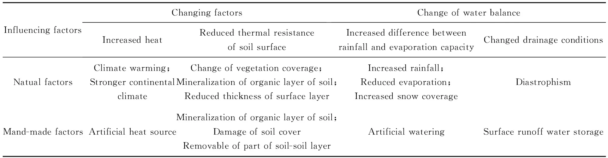
Table 1 Changing factors and influencing elements during formation of Alas
Many Russian scientists have been engaged in research of Alas in different periods[20]. The cause of formation of Alas can be explained as follows: Alas is formed when perennial glacial soil thaws for certain reasons[21]. Since the thickness of permafrost in central Yakutia varies from 100 to 450 m[22], Alas occurs in areas with perennial freezing and uneven soil settlement[23]. Similar landforms of Alas also spread widely in North America. Alas in central Yakutia is a dynamic system closely related to climate change. The center of Alas is usually covered by lakes, surrounded by strips of swamps, meadows, grassland vegetation and corresponding soils[24-25]. According to the thickness of underground ice, development depth of Alas is 2~30 m. Alas accounts for a considerable area in central Yakutia[26]. For example, it accounts for 20%~30% in the Lena-Amga basin[27].
1.3 Development stages of Alas in central Yakutia
1.3.1 Stage 1: Settlement occurs
When climate turns warmer, the perpetually permafrost starts to thaw from top. With increased seasonable thawing, an inclination is formed at places where permafrost contains a large amount of ice. The stage 1 of the formation of Alas-the settlement of soil is showed in Fig.2. Then, water begins to accumulate in the depression. The dead trees still exists in the original frozen soil layer, but will disappear with the increase of depth of settlement. The depression will expand with temperature rise[28].
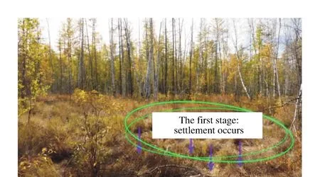
Fig.2 Stage 1 of development of Alas
1.3.2 Stage 2: Formation of lakes
As a closed or semi-closed Alas depression, the development of Alas is almost completely dependent on the underground ice layer. The mature stage comes when the ice layer is completely thawed. That is, in the absence of runoff, the thawed ice which runs through subsided depressions will form lakes in coniferous forests in Yakutia. This is the stage 2 of formation of Alas, as shown in Fig.3. In winter, however, the seasonally thawed soil layer does not integrate with perpetually permafrost. With passage of time and constant climate changes, the expansion of depression boundary slows down. A part of water in the later-formed lakes evaporates into the air in atmospheric circulation, with another part absorbed by the thawed soil beneath the lake. At this stage, depression gradually forms a basin and a large amount of vegetation began to grow along the edge[28].
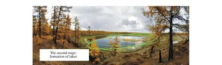
Fig.3 Stage 2 of development of Alas
1.3.3 Stage 3: Vegetation coverage
Due to the dominant continental climate, the evaporation is greater than precipitation in Yakutia, resulting in gradual thawing and stagnated development of ice layer beneath Alas. With constantly increased difference between rainfall and evaporation, lakes gradually dry up. At this time, Alas deteriorates into perpetually frozen soil area again and is re-covered by vegetation[28], as shown in Fig.4.
Fig.4 Stage 3 of development of Alas
1.4 Development law of Alas in central Yakutia
In central Yakutia, Alas mainly forms in a zone where there is ice-and-snow complex on land surface, while ice-and-snow complex is the geomorphic foundation of the central Yakutia. This landform mostly develops in periods of humid climate with abundant rainfall[29]. Under current conditions, due to the increasingly arid climate in central Yakutia, the development of Alas has slowed down significantly[30].
The number of alases in Central Yakutia reaches 16 000 with an area of 4 400 km2. The depth of individual Alases varies from 2 to 30 m. In central Yakutia, Alas is distributed disorderly, with special soil, meadow vegetation, microclimate and fauna. Most developed Alas is a closed elliptical or circular basin, with a slope angle of 45°~70° and a slope height of 15~60 m or higher in general.
For example the Churapcha area is characterized by an almost flat surface at about 180~200 m above sea level with Thermokarst depressions (alas, with a relative depth of about 7~8 m) permafrost depth of 12~14 m, which lie at a depth of 2.2~2.3 m below the surface. Field measurements the width of the upper parts of permafrost varies from 1.5 to 3.0 m. Subsidence rate of this area was estimated as 2.1~3.9 cm·a-1[31].
In addition,the intensity of change of water level change in Alas is inversely proportional to the amplitude of temperature in summer. In drought years, evaporation of Alas lakes is 2~10 times that of the rainfall. The size of Alas depends on the thickness of the underground ice layer and rock composition etc. Its length and width also vary with distribution of the underground permafrost layer which may as extend for several kilometers. In Yakutia, most Alas is distributed in Myuryu, Tyungyulyu, Maya, Syrdakh, Chuya, Chyla and other places.
2 Conclusions
The perpetually permafrost area in Yakutia is affected by the climate. With constantly increased thickness of the active layer of permafrost , the soil continues to sink. After two development stages, the Alas (lake) is gradually formed. Furthermore, varied thickness of permafrost layer also contributes to wide chaotic distribution of Alas in Yakutia. The size of the landform is greatly influenced by geological structure.
The Yakutia is located on the world’s largest permafrost area, with dominant continental climate. Since the development of Alas is becoming mature, strengthened research on the Alas in this region is not only helpful to scientific and theoretical study of Chinese arid regions which are also located in perpetually permafrost area with significant continental climate, but also provides references for the development and utilization of such landform in China.
猜你喜欢
农业工程学报(2022年7期)2022-07-09
现代畜牧科技(2021年4期)2021-07-21
冰雪运动(2019年1期)2019-07-22
科技创新与应用(2017年10期)2017-04-26
故事作文·高年级(2016年12期)2016-12-16
故事作文·高年级(2016年7期)2016-07-26
小星星·阅读100分(高年级)(2015年2期)2015-01-30
环球时报(2014-10-08)2014-10-08
环球时报(2014-02-17)2014-02-17
环球时报(2012-02-06)2012-02-06