
Tidal Characteristics in the Wenzhou Offshore Waters and Changes Resulting from the Wenzhou Shoal Reclamation Project
2015-10-14 13:08BAOMinBAOXianwenYUHuamingandDINGYang
BAO Min, BAO Xianwen, YU Huaming, and DING Yang
Tidal Characteristics in the Wenzhou Offshore Waters and Changes Resulting from the Wenzhou Shoal Reclamation Project
BAO Min1), 2), BAO Xianwen1), 3), *, YU Huaming1), and DING Yang3)
1),,266100,2),,,310012,3),,266100,
The Wenzhou Shoal Reclamation Project is the core part of Wenzhou Peninsula Engineering which is a big comprehen- sive development project to expand the city space. The dynamics of the surrounding area was proved to suffer little effect in response to the Lingni north dyke since it was built approximately along the current direction. Therefore, this paper focuses firstly on the tidal characteristics in the Wenzhou and Yueqing bays with the Lingni north dyke being built and then on the changes resulting from the implementation of the on-going Wenzhou Shoal Reclamation Project (WSRP) which will reclaim land from the whole Wenzhou Shoal. To simulate the tidal dynamics, a high-resolution coastal ocean model with unstructured triangular grids was set up for the Wenzhou and Yueqing Bays. The model resolved the complicated tidal dynamics with the simulated tidal elevation and current in good agreement with observations. In the study area, M2is the predominant tidal component, which means the tide is semidiurnal. The new reclamation project hardly affects the Yueqing Bay and the open ocean, but there are concentrated effects on the mouth of the southern branch of the Oujiang River and the southwest of Wenzhou Shoal. This study provides an indicative reference to the local government and helps to weigh the advantages and disadvantages of the project.
Wenzhou Shoal; reclamation; numerical model; tidal characteristics; effects
1 Introduction
The Oujiang River is the second longest river in Zheji- ang Province. The strongest runoff of the Oujiang River occurs between March and August, and typically accounts for about 76.1% of the total annual runoff. The multi-year mean runoff of Oujiang River at Yuren station is 422.9m3s−1, with a maximum peak discharge of 22800m3s−1and 10.6m3s−1at the trough. The maximum discharge is usu- ally in June while the minimum appears from October to February. The ratio of maximum to minimum discharge in the same month ranges between 3–23. The Oujiang River splits into the North Branch and the South Branch at Lingkun Island before entering the Wenzhou Bay. The flow splitting ratio between the South Branch and the North Branch is 16:84 on a flood tide and 25:75 on an ebb tide (Li and Li, 2009). The South Branch is in atro- phic condition, while the North Branch is the main access to the sea. In addition, there is a submerged breakwater across the South Branch that causes siltation.
Wenzhou’s economy is developing rapidly and more and more land resources are needed. This has led to expansions into islands within Wenzhou Bay. The Wen- zhou Shoal Reclamation Project is the core part of Wen- zhou Peninsula Engineering which is a big comprehend- sive development project to expand the city space. The Lingni north dyke is part of the Wenzhou Shoal Reclama- tion Project, and has been built to connect LingKun Is- land and Niyu Island forming a part of a high-way called the 77thprovincial road. This high-way is at the northern boundary of Wenzhou Shoal which is the biggest and most developed sandbar in Wenzhou and Yueqing Bays (Li, 2005). According to the previous study, the dy- namics of the surrounding area has little changes resulting from the Lingni north dyke since it was built approxi- mately along the current direction. However, the actual situation of tidal dynamics after the construction of the Lingni north dyke should be confirmed. The on-going Wenzhou Shoal Reclamation Project will reclaim land from the whole Wenzhou Shoal, and its effects on the regional tidal dynamics should be evaluated.
In recent decades, various kinds of marine projects have been carried out in the world, especially the tidal flat reclamation, and a lot of work about the tidal characteris- tic variation due to the reclamation has been done (Byun, 2004; Ge and Zhang, 2011; Hasegawa, 2011; Hodoki and Murakami, 2006; Jiang, 2009; Kang, 1999; Liu, 2011; Son and Wang, 2009; Song, 2013; Wang, 2012). It is very fundamental and nec- essary to study the tidal characteristics in the Wenzhou and Yueqing bays and the change resulting from the implementation of the Wenzhou Shoal Reclamation Pro- ject.
To answer these questions, we built a fine-resolution hydrodynamic model of Wenzhou and Yueqing Bays which includes all tidal flats to study the tidal dynamics. In Section 2, a description of the numerical model is pre- sented. The model is validated in Section 3. Finally, model results and discussion are presented in Section 4.
2 Model Construction
2.1 Model Description
The finite volume coastal ocean model (FVCOM) is a prognostic, unstructured-grid, finite-volume, free-surface, three-dimensional primitive equations ocean model (Chen, 2003, 2007). The unstructured grid used in FVCOM is useful for estuaries with complicated shorelines and multiple islands such as the case of Wenzhou Bay (Li and Wang, 2002). The wet/dry treatment technique is also applied in FVCOM, which provides an accurate simula- tion of the water transport flooding into and draining out of the inter-tidal zone and adhering to the conservation of mass. The wet/dry process is very important in the Wenzhou Bay because there are many shallow, tidal areas such as the Wenzhou shoal and South Branch of the Oujiang River.
The-coordinate transformation is applied vertically in order to obtain a smooth representation of irregular vari- able bottom topography. The-coordinate transformation is defined as

wherevaries from −1 at the bottom to 0 at the surface.is the total water column depth defined as=+, whereis the base depth andis the free surface height. The Mellor and Yamada 2.5 level turbulent closure model (Mellor and Yamada, 1982; Mellor, 2004) is applied in this model to calculate the vertical eddy viscosity and thermal diffusion coefficient, and the Smagorinsky scheme (Smagorinsky, 1963) is used for horizontal mixing. The drag coefficientCis determined by matching a logarith- mic bottom layer to the model at a heightzabove the bottom,
, (1)
where=0.4 is the von Karman constant and0is the bottom roughness parameter.
2.2 Model Domain
The model domain is shown in Fig.1, including the Oujiang River, Nanxi River, Feiyun River and Aojiang River, and 46 islands of various sizes and shapes. The model domain spans about 102.5km from east to west and about 126.5km from north to south in order to keep all open boundary nodes in the open ocean far away from the Wenzhou Shoal Project, reducing the additional ef- fects of the open boundary on the hydrodynamics near the Wenzhou Shoal.
The domain is configured with 31830 nodes and 60839 elements in the horizontal plane based on all the available bathymetry and shoreline data. Fig.1a shows the config- uration of the whole model domain. The resolution is coarse near the open boundary at approximately 5800m, but much finer in the estuary; around Wenzhou Shoal it is especially high,, about 20m. Vertically, sevenlayers are specified which is consistent with the resolution of the observed current data. Station 1# in Yueqing Bay and station 30# (Fig.1b) at the mouth of the north branch of the Oujiang River were used to validate the model-simu- lated tidal current including vertical profiles. Stations Longwan and Dongtou were selected to verify the model-calculated tidal elevation.
The water depths in the model (Fig.1c) range from 116.6m below to 4.4m above the undisturbed sea surface. The isobaths in this domain are almost parallel to the coastline but in the narrow channel between islands they can reach more than 30m and even 100m depth near Dayantou. The intertidal zones are widely distributed and the Wenzhou Shoal can be located easily between the Linkun island and Niyu island Fig.1b). The 20m depth contour is nearly 4km far away from the shoreline.
2.3 Boundary Forcing and Initial Conditions
The seaward open boundary is placed far away from the Wenzhou Shoal, extending to the open ocean and past Nanji Island (Fig.1). The open boundary conditions for water elevation are specified using tidal elevations pre- dicted by TPXO7.2 which is a global ocean tidal model downloaded from http://volkov.oce.orst.edu/tides/TPXO7.2.html. The open boundary tidal forcing at hourly interval is constructed by the tidal constituents of K1, O1, P1, Q1, M2, S2, N2, K2, M4, MS4, MN4, Mf, Mm.
This paper focuses on the hydrodynamics in the wet season. The freshwater discharge from the rivers in this region is very important to the local hydrodynamics. The average runoff during the simulation period is 913.4, 126.7, 189.8 and 78.5m3s−1for the Oujiang River, Nanxi River, Feiyun River and Aojiang River respectively. The available runoff data at daily interval was obtained from water resources monitoring stations.
As Mehta’s classification scheme for the tidal range Ω (Mehta, 1988; Li, 2012), the primary hydrodynamic forces are tidal currents, wind waves and wind currents when Ω<1.0m; tidal currents and wind waves when 1.0≤Ω≤3.0m; and only tidal currents when Ω>3.0m. The tidal range around this region is over 4.0m, and according to the above classification, the dominant hydrodynamic force in this region is the tidal current only. Therefore, both wind forcing and heat flux at the surface were ignored in our model simulations.
In order to resolve the complex tidal processes of wet- ting and drying in the wide intertidal region, a wet/dry treatment technique was applied in our model to simulate the flooding and ebb tidal process.
The model was initialized with constant salinity and temperature, zero heat flux at the surface, open boundary tidal elevation forcing and freshwater discharges, which results in barotropic conditions in the model. The model was run for totally 45 days from 1 June to 15 July 2005.
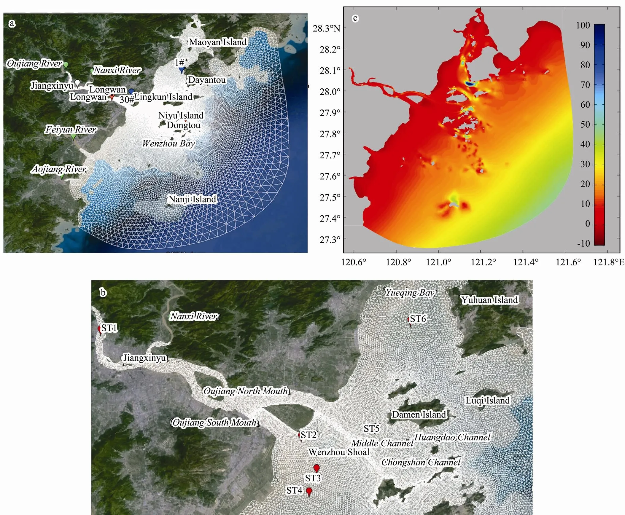
Fig.1 (a) Map and mesh of the study domain with tidal gauge station in Longwan and Dongtou. The current stations 1# and 30# are marked by red and blue dots, respectively; (b) detail of Oujiang Estuary and the location of ST1-6; (c) bathymetry of the study domain.
2.4 Numerical Experiments
The Wenzhou Shoal is the largest and the most mature sandbar in Wenzhou estuary, and is located between Ling- kun Island and Niyu Island. Wenzhou Shoal Reclamation Project (WSRP) is a large project for reclamation of the tidal flats, the purpose of which is to alleviate limitations in urban development and land shortage. The control ex- periment including the built Lingni north dyke is shown in Fig.2a. The validation data were observed during June and July 2005 after the Lingni north dyke was completed. In order to evaluate the effects of WSRP on tides, a new experiment was designed (Fig.2b), in which the Wenzhou Shoal was completely enclosed for reclamation of land, thus resulting in a new coastline.
3 Model Validation
3.1 Sea Surface Elevation
The observed hourly sea surface elevation data (pro- vided by the Wenzhou Shoal Reclamation Project) during the model period were used to validate the model-simu- lated elevations. There were two observation stations for elevation: Longwan station located in the estuary, and Dongtou station located on the seaward side of Wenzhou Bay (as shown in Fig.1a).
Table 1 and Table 2 show the comparison of harmonic parameters (amplitude and phase) for the main tidal components M2, N2, S2, K1and O1at Longwan and Dongtou stations. In this region M2is the predominant tide, meaning that the tidal period in Wenzhou Bay is semidiurnal. The difference between the observed and modeled M2amplitudes and phases are 2.3%/4˚ and 3.0%/7˚ for Dongtou and Longwan stations respectively. The large differences between the observation and modeled values O1, K1(at Dongtou station), and S2(at Longwan station) phases are mainly because one-month sea surface elevation data is too short to resolve all the tidal components accurately. Fig.3 shows a very good consistency between the simulated and observed sea surface elevation at Longwan and Dongtou stations. Overall, the model shows good agreement between the modeled and observed sea surface elevations.

Fig.2 The schematic map of (a) control experiment and (b) new experiment, and the location of Lingni north dyke and WSRP.

Table 1 Harmonic parameters comparison of model outputs and field observations at Dongtou station

Table 2 Harmonic parameters comparison of model outputs and field observations at Longwan station

Fig.3 Comparisons of model (black solid line) and observed (red plus) sea surface elevation at Longwan station and Dongtou station.
3.2 Tidal Currents
There are two tidal current validation stations, 1# and 30# (Fig.1), where currents were measured at 6 vertical layers during spring, medium and neap (shown in Table 3) tides. The tidal cycle in this domain is semidiurnal and thus has two cycles per day. Fig.4 compares modeled and observed current speeds and directions of the two stations at the surface layer, the 0.4H layer, bottom layer and ver- tically averaged current. Note from Fig.4 that the current phases through the water column vary little however the speed decreases. Tidal flows at these two stations are mostly back-and-forth with the flooding tide.
Both the simulated speed and expected direction are consistent with the observed current at each layer (only the surface layer, 0.4H layer, bottom layer and vertically averaged current are shown in Fig.4).
In conclusion, our model can well resolve the tidal elevations and currents and can be used to simulate hydrodynamic processes in the study domain.
Table 3 Current observation duration for spring, medium and neap tide

Fig.4 Comparisons of modeled (red lines) and observed (black dots) tidal current speed and direction at station 1# and station 30#.
4 Model Results and Discussion
4.1 Tidal Characteristics in Wenzhou and Yueqing Bays
The locations with depth less than 3.0m are not taken into account for harmonic analysis, since the average tidal range in this study domain is 3.99–4.52m. The amplitudes and phases of the M2tidal constituent are shown in Fig.5. The amplitudes increase gradually from about 1.5m near the open boundary to about 2.0m near Jiangxinyu in the Oujiang River and to about 2.1m near Maoyan Island in Yueqing Bay. The phase increases from the open boundary to the inside bays and the upper Oujiang River.
Fig.6 shows the vertically averaged velocities of the rising and ebbing tidal currents simulated by the model, the plot resolution for the velocity vectors being about 2.0km grid for showing purpose. The tidal currents between islands and near the estuary are much larger than those in other areas which can exceed 1.0ms−1with the maximum 1.9ms−1. Tidal current speeds fall to zero during ebbing in the intertidal zones. During flooding time, the water from open sea enters Yueqing Bay through the channels of Yuhuan Island–Luqi Island and Luqi Island–Damen Island. The water flows through Chongshan Channel, Huangdao Channel, Damen Channel, Xiaomen Channel and Shatou Channel to Oujiang North Mouth, and the water flowing to the Oujiang South Mouth is from the west of Niyu Island. During ebbing time, the water flow- ing out through Damen Channel, Xiaomen Channel and Shatou Channel joins the water from Yueqing Bay in the north of Damen Island, and goes to the open sea mainly through channel of Damen Island-to-Luqi Island. There is no direct water exchange between Yueqing Bay and Wen- zhou Bay, consistent with earlier studies (Jiang, 2009).
The M2tidal current ellipses at different vertical layers at the six locations are shown in Fig.7. The ellipse orient- tations depend on the directions of tidal current at the six locations. The major axes of tidal current ellipse of the M2tide decrease from the surface to the bottom at all six locations due to the bottom friction. The decrease is more rapid at Locations 1, 3 and 4 because of the shallower water depth compared to that at Locations 2, 5 and 6, the reductions being 42% and 38% respectively.
The tidal current ellipse orientations of M2constituent at the six locations are shown in Fig.8a. The current di- rections at all layers are all roughly in the northwest-southeast direction except at ST1. The current orient- tations are restricted by the coastlines and the deep chan- nels. ST1 is located in the upper stream of the curved river channel, so the current orientation is controlled by the direction of channel. At other locations, the restriction effect is much weaker. The horizontal distribution of the M2tidal current ellipses is shown in Fig.8b. The tidal current ellipses in the southwestern area of the study do- main are elliptical, while most of others are rectilinear.

Fig.5 Amplitudes and phases of the M2 tide analyzed from tidal elevation with the model.

Fig.6 Vertically averaged velocities of the rising (2005-06-23-20:00 left) and ebbing (2005-06-24-02:00 right) tidal currents from the model.

Fig.7 Vertical distribution of the M2 tidal current ellipses at the six locations in Fig.1b from the model.

Fig.8 (a) M2 tidal current ellipse orientations at the six locations from the model; (b) the distribution of M2 vertically averaged tidal current ellipse from the model.
4.2 Changes of the Four Main Tidal Constituents Due to the WSRP
4.2.1 Variation in tidal harmonic constants
The patterns of the variation in M2, S2, O1and K1amplitudes and phases are similar Fig.9. The amplitudes are reduced for all the four main tidal constituents when the WSRP is finished. The largest amplitude reduction is 0.03m for S2, O1and K1, but 0.06m for M2near the mouth of the Oujiang south branch. The phases for all four main constituents increase near the mouth of the Oujiang south branch but decrease near Niyu Island, while changing slightly in other areas. The largest phase increase is 4.0˚ for S2while the largest reduction is 2.0˚ which occurs for nearly all the four main constituents. There is a minor effect on the Oujiang River (excluding the mouth of the south branch). The M2amplitude is affected more than other constituents where M2is predominant with the largest amplitude. But for the phase, S2is changed most and has the largest effect zone.
4.2.2 Variation in current harmonic constants
Six stations are selected to describe the change in tidal currents, and the major axes of the four primary constitu- ents for the vertically averaged tidal currents before and after the WSRP are shown in detail in Table 4. ST1 is located upstream in the Oujiang River, ST5 is in the Mid- dle Channel, and ST6 is in the Yueqing Bay (Fig.1b). The major axes of the four primary constituents of the verti- cally averaged tidal current before and after the WSRP change slightly at these three stations. But the stations along the mouth of the Oujiang south branch (ST2) and near Niyu Island (ST3 and ST4) have large changes in the major axes.

Fig.9 Changes in the M2, S2, O1 and K1 amplitudes and phases before and after Wenzhou Shoal Project.

Table 4 Major axes of the four main constituents for the vertically averaged tidal current before and after the WSRP
5 Conclusions
A high-resolution coastal ocean model with unstructured triangular grid was applied to simulate the tide and tidal dynamics in the Wenzhou offshore waters. The model well resolved the complex tidal dynamics in this region with the tidal elevation and tidal current simulated. The model results correspond well withobservations.
In the study area with the Lingni north dyke being built, M2is the predominant tidal component, which means the tide is semidiurnal. The amplitudes increase gradually from about 1.5m near the open boundary to about 2.0m near Jiangxinyu in the Oujiang River and to about 2.1m near Maoyan Island in Yueqing Bay. The phase increases from the open boundary to the inside bays and the upper Oujiang River. The tidal currents in the study area flow mostly back-and-forth. The current orientations are re- stricted by the coastlines and the deep channels. The tidal current ellipses in the southwestern area of the study do- main are elliptical, while most of the others are rectilin- ear.
To evaluate the effects of the implementation of WSRP on the hydrodynamics around the Oujiang Estuary, an additional model experiment was performed that explains the changes of coastline. There is no major effect in the Yueqing Bay or in the open ocean. The main regions of change stretch from the Wenzhou Shoal to offshore of the Feiyun River. The amplitudes are reduced for most of the four main tidal constituents after the WSRP. The phases for all four main constituents increase near the mouth of the Oujiang south branch and decrease near the Niyu Is- land. In addition, the M2amplitude is more greatly af- fected than the other constituents in the affected area. However, as for the phase, S2 is influenced most and has the largest effect zone.
The change of major axes of the four main constituents for the vertically averaged tidal current at the selected stations shows that the tidal currents change slightly at ST2, ST3 and ST4 after the WSRP, and the project in the Oujiang Estuary has limited effect on the hydrodynamics in Yueqing Bay and in the open ocean.
The new reclamation project causes no major effects in Yueqing Bay and the open ocean, but there are concen- trated effects on the mouth of the southern branch of the Oujiang River and southwest of Wenzhou Shoal. This study provides an indicative reference to the local gov- ernment and helps to weigh the advantages and disadvan- tages of the project. However, research is still needed to evaluate the influence of the project on ecosystems in this region in the future.
Acknowledgements
This work was supported by the National Basic Re- search Program of China (Grant no. 2010CB428704) and the National Nature Science Foundation of China (Grand nos. 41276083, 41430963). We thank Mr. Sam Truesdell from University of Maine for suggestions and language improvement on this manuscript.
Byun, D. S., Wang, X. H., and Holloway, P. E., 2004. Tidal characteristic adjustment due to dyke and seawall construction in the Mokpo Coastal Zone, Korea.,59: 185-196.
Chen, C. S., Huang, H. S., Beardsley, R. C., Liu, H. D., Xu, Q. C., and Cowles, G., 2007. A finite-volume numerical approach for coastal ocean circulation studies: Comparisons with finite difference models., 112, C03018, DOI: 10.1029/2006JC003485.
Chen, C. S., Liu, H., and Beardsley, R. C., 2003. An unstructured, finite-volume, three-dimensional primitive equation ocean model: Application to coastal ocean and estuaries., 20: 159-186.
Ge, Y., and Zhang, J., 2011. Analysis of the impact on ecosystem and environment of marine reclamation–A case study in Jiaozhou Bay., 5: 105-111.
Hasegawa, D., Sheng, J., Greenberg, D. A., and Thompson, K. R., 2011. Far-field effects of tidal energy extraction in the Minas Passage on tidal circulation in the Bay of Fundy and Gulf of Maine using a nested-grid coastal circulation model., 61: 1845-1868.
Hodoki, Y., and Murakami, T., 2006. Effects of tidal flat recla- mation on sediment quality and hypoxia in Isahaya Bay., 16: 555-567.
Jiang, H. Z., Shen, Y. M., and Wang, S. D., 2009. Numerical simulation study on three-dimensional tidal flow and salinity in the Oujiang Estuary., 24: 63-70.
Kang, J. W., 1999. Changes in tidal characteristics as a result of the construction of sea-dike/sea-walls in the Mokpo Coastal Zone in Korea.,48: 429-438.
Li, L., Wang, X. H., Williams, D., Sidhu, H., and Song, D., 2012. Numerical study of the effects of mangrove areas and tidal flats on tides: A case study of Darwin Harbour, Australia.,117 (C6): 1-12,DOI: 10.1029/2011JC007494.
Li, M. G., and Li, W. D., 2009. Study on schemes for stopping flow in South Branch of Oujiang Estuary., 161: 19-22.
Li, M. G., and Wang, Z. L., 2002. Tidal flow numerical simulation of the Oujiang Estuary., 19: 19-22.
Li, M. G., Qin, C. R., and Jiang, H. W., 2005. Application of multi-elements’ mathematical model in the study on reclama- tion of Wenzhou Shoal at Oujiang Estuary., 4: 62-66.
Liu, X. J., Gao, S., and Wang, Y. P., 2011. Modeling profile shape evolution for accreting tidal flats composed of mud and sand: A case study of the central Jiangsu coast, China., 31: 1750-1760.
Mehta, A. J., 1988. Laboratory studies on cohesive sediment deposition and erosionIn:. Dronkers, J., and van Leussen, W., eds., Springer, Berlin, 427-445.
Mellor, G. L., 2004.Princeton University, Princeton, 56pp.
Mellor, G. L., and Yamada, T., 1982. Development of a turbulence closure model for geophysical fluid problem., 20: 851-875.
Smagorinsky, J., 1963. General circulation experiments with the primitive equations, I. The basic experiment., 91: 99-164.
Son, S., and Wang, M., 2009. Environmental responses to a land reclamation project in South Korea., 90 (44): 398-399.
Song, D., Wang, X. H., Zhu, X., and Bao, X., 2013. Modeling studies of the far-field effects of tidal flat reclamation on tidal dynamics in the East China Seas., 133: 147-160.
Wang, Y. P., Gao, S., Jia, J., Thompson, C. E., Gao, J., and Yang, Y., 2012. Sediment transport over an accretional intertidal flat with influences of reclamation, Jiangsu coast, China., 291-294: 147-161.
(Edited by Xie Jun)
DOI 10.1007/s11802-015-2498-z
ISSN 1672-5182, 2015 14 (6): 931-940
© Ocean University of China, Science Press and Springer-Verlag Berlin Heidelberg 2015
(September 29, 2013; revised November 8, 2013; accepted September 2, 2015)
* Corresponding author. Tel: 0086-532-66781827E-mail: xianwenbao@126.com
 Journal of Ocean University of China2015年6期
- Journal of Ocean University of China的其它文章
- An Improved Lower Order Method of Modal Parameter Estimation for Offshore Structures Using Reconstructed Signals
- Inversion Study on Pollutant Discharges in the Bohai Sea withthe Adjoint Method
- Different Responses of Sea Surface Temperature in the North Pacific to Greenhouse Gas and Aerosol Forcing
- The Change Features of the West Boundary Bifurcation Line of the North Equatorial Current in the Pacific
- Wave Pressure Acting on V-Shaped Floating Breakwater in Random Seas
- Dynamic Response of a Riser Under Excitation of Internal Waves