
新加坡·南京生态科技岛滨江风光带(大江侧)示范区景观设计
2018-11-19 03:07AECOM
风景园林 2018年9期
AECOM
项目位置、规模和范围
因受环境污染、栖息地破坏和生物多样性降低等问题的影响,修复长江生态环境是中国环境修复的重点。在南京市域内长江下游段,新加坡·南京生态科技岛在进行城市化发展的同时,也在不断改善其滨水生态环境。
新加坡·南京生态科技岛(以下简称“生态岛”)位于长江之中,距南京市中心仅6.5km,岛屿整体呈优美的流线形。2009年,中新南京生态岛投资发展有限公司在保护和提升生态岛现有生态环境的基础上,着力打造一座集高科技产业发展、低碳生活、休闲旅游综合功能为一体的城市典范。
2014年,生态岛大江侧滨江风光带项目面向国际发起竞标。场地位于生态岛西侧,面向长江,自南向北绵延12km,占地约210hm2。AECOM在竞赛中获胜,其景观概念设计从构建15km2的岛屿绿色基础设施的角度出发,提供了一个全面的解决方案。生态岛的设计理念旨在通过自然和自然系统的营造,提升场地的环境和生态价值。为达成这一目标,该方案设置了几个关键的开放空间节点。第一阶段(示范区)于2016年竣工,为该新兴的生态城市提供了丰富的野生动物栖息地空间,对恢复当地生物多样性、构建生态网络起到了重要作用。
在背景研究中,项目组调查了区域的土地利用、排水、开放空间和交通规划。项目组还联合其他专业团队,进行了详细的生态调查、洪水风险评估、地下水和岩土工程调查,在洪峰期间进行的多次现场勘察,使项目组了解场地限制和极端气候的潜在影响。
设计理念
项目的设计理念为“可持续的足迹”,旨在通过建立风景秀丽的环岛路,提供骑行、慢跑、马拉松和游园的连续线路,减少岛屿内部的碳、生态和水足迹,同时凸显长江的文化特征,促进健康的生活方式。设计尽量保留场地原有的工业、农业遗迹,通过使用本土材料、循环利用再生材料以及选用本土植物品种等策略,在减少岛屿碳足迹的同时提高城市韧性。这一设计理念在最近竣工的示范区中得到完美的体现。示范区的建立有利于恢复大片野生动物的栖息地、减轻岛屿防洪基础设施对景观的视觉影响,并通过地形合理规划雨水收集系统,实现土方平衡。
示范区特色
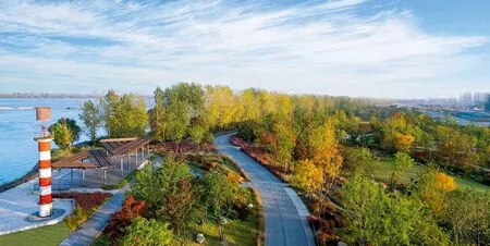
项目要求对受到影响的滨水湿地生态区进行保护和加强,并最大限度地保留现有森林。在保护岛屿免受洪水侵袭的多层防御体系中,滨水堤坝是其中最为重要的一道防线。项目组因势利导,结合这一传统的水利工程,利用堤顶道路,为骑行者和慢跑者打造一条滨江观景路线。
为保护公众健康和安全,前往防洪堤外森林的通道被严格限制。天然石阶连接着坚固的透水钢格栅路,在现有的杨树和柳树林之间迂回。在现场勘察期间,项目组选择性地疏伐部分枯树,为森林再生提供空间;砍伐的木材被原地安置,为野生小动物提供栖息地。通过钢格栅路可穿过森林到达长江上的观景点,在抵达水边时,平台旁边高大的柳树凝望着长江。

1 项目基地南京江心岛地处长江中下游,包括一条面向长江、自南向北绵延12km的大江侧滨江风光带The project is located at Jiangxin Island to the lower reaches of the Yangtze River Delta in Nanjing. The work included a landscape framework plan for the island loop and landscape design for the 12 km long waterfront scenic belt facing the Yangtze River
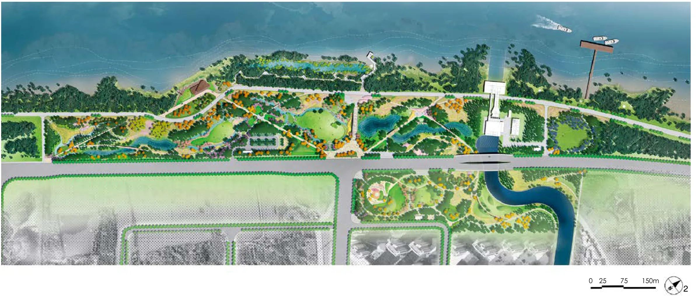
2 示范区结合防洪措施进行景观化处理,旨在打造一个促进人与自然共存的生态社区,包含原生河岸森林以及社区公园2个部分Phase one demonstration area is primarily programed as an ecological community that fosters co-existence between people and nature. Flood protection engineering resulted in two ecological zones: native riparian forest and a protected community park
3 本项目修复了生态系统,还为游客提供了观赏长江壮阔景象的平台。通过钢格栅路,便可穿过森林到达长江上的观景点,遥望长江这条世界上最繁忙的河流The project restores ecological systems and celebrates the majestic scene of the Yangtze River taking advantage of an existing forest clearing to create a view point and gathering place overlooking China’s longest and busiest river
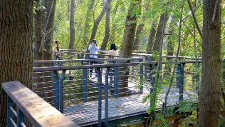
4 天然石阶连接着坚固的透水钢格栅路,在现有的杨树和柳树林之间迂回A low impact permeable steel boardwalk zig-zags between existing trees taking advantage of gaps and clearings, here seen as a peak annual flood recedes

5 在防洪堤内,通过生态草沟收集到的雨水被汇入生态滞留池Inside the flood protection levee, stormwater runoff is harvested in vegetated swales which passes under bridges to detention ponds

6 从连接着入口广场与雨水花园的景观桥可以俯瞰收集场地近半数雨水的滞留池An elegant sloping bridge links the entrance plaza to the flood protection levee through/ on which peple can overlook open space, wetlands and detention ponds
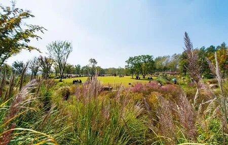
堤坝内的开放空间节点,在为野生动植物提供庇护所的同时,也为周边社区的居民提供与自然亲近的活动。走过天然石阶和在多年生及湿生植物中灵活散布的踏脚石块,人们可以进入一片开阔的草坪。本土乔木在夏、秋两季时为游人遮荫。在舒适的草坪边缘,大块的石头随机排布,供人小坐休憩或玩耍。项目充分运用了海绵城市雨水管理策略,通过生态草沟收集到的雨水汇集进入生态滞留池,形成优美的景观水体。一条慢跑步道横跨水面,游客经过时可以近距离欣赏这一生态举措带来的美景。
通过居住区附近的入口进入公园,迎面而来的便是一座连接着入口广场与雨水花园的景观桥,从此处可以俯瞰收集场地近半数雨水的滞留池。滞留池以及雨水花园很好地体现了海绵城市的设计理念,极具生态教育意义。桥的两端设有耐候钢板景墙,上面刻有流线形的岛屿图案,景桥与堤顶路相连,驻足于此,可以看到堤外现有的茂密杨树和柳树林。
防洪堤面向岛屿内部的一侧,经由微地形改造形成了适合再生林和野花草甸生长的缓坡。当夕阳的余晖洒向坡上的花草时,这些缓坡变得极具吸引力,特别是在秋季的暖阳下。
停车场使用透水混凝土铺装、生态草沟和丰富的混植植物,以确保停车场的生态性。与堤顶路相连的碎石小径在草坪周围的林间穿梭。入口广场一条长长的大道延伸到可以俯瞰长江的观江景亭。景亭的“Y”型钢柱造型灵感源自长江中多见的河道分叉形态,这也是沉积岛形成的主要原因。这个“Y”型结构也被广泛应用到整个公园的栏杆、构架和路径布局上。
森林小径的透水钢格栅可经受住季节性的洪水。2016年南京经历了自1998年以来最为严重的暴雨和洪水,但由于设计坚固,森林小径结构承受住了钢板表面超过2m的洪水。为确保人员健康和安全,森林小径的入口处设立了可封闭的门禁,以防止游客在汛期进入。
7 景观设计对堤坝背水坡的地形进行了重整,适当增加覆土,为重新造林,生态草沟、草甸和休憩的草坪提供了空间Generous soil depths behind the flood protection line enable reforestation, tall grasses, wildflower meadow grassland and amenity grassland for community activities
环境影响与设计要点
在城市化和气候变化的背景下,景观在塑造韧性城市中发挥着越来越重要的作用。该项目面临的一大挑战是在现代城市发展的背景下,如何重新唤起人们对自然种植和本土植物的认可。该项目的一个重要设计目标是通过精密的季相种植组合恢复自然植被的活力。这需要充分了解植物生态习性及其在不同环境下的表现,以确保栖息地生态系统能够有效运作,在洪水、干旱和城市压力的威胁下保持稳定。
与常规公园不同,该大江侧滨江风光带示范区内进行了多样化的种植设计,增加种植组合中本土落叶乔木、多年生植物和观赏草的使用。高水位以及广泛分布的生态草沟和雨水花园系统,形成了浅层植被洼地,在捕获雨水径流的同时将水储存在滞留池中。这些天然过滤器不仅改善了水质,为野生动物提供栖息地,也是生态设计中的一大亮点。
现场种植了大片的粉黛乱子草(禾本科,较耐水湿),随着季节的变化呈现不同的色彩。春日,绿色的针状草叶生出,并在夏季逐渐成熟,为多年生植物和夏末花卉提供了极佳的观赏背景。秋日,大片粉黛乱子草笼罩上一层轻盈的粉色,如同一片片云彩,创造了一幅壮观的粉色云霞图。深秋时节至冬日,粉红、紫色及白色的花朵逐渐褪去色彩,露出褐色的种子,作为昆虫和鸟类的食物来源,这些种子吸引各类有益的昆虫,如蝴蝶和瓢虫等。大片丛生的植物也为其他野生动物提供了栖息地。
在防洪堤外,项目组还种植了一些本土乔木混合林作为替代目前占据林地、生命周期相对短暂的杨树林的演替林带。这一策略来源于日本植物学家和植物生态学家Akira Miyawaki教授的理论。种植区随机分布在空旷的区域或现有森林的边缘,为20~30年后的森林提供后续生长的方向。
项目亮点
设计的成功归功于政府、业主、设计师、工程师和分包商之间的紧密合作。示范区建造的亮点包括滨江风光带的生态种植,贯彻低影响设计以及海绵城市设计理念。2017年10月的几个周末,累计超过5万名游客到访生态岛,共赏粉黛乱子草的盛放之美。城市自然主义和本土生态种植的融合吸引了许多当地居民和摄影爱好人士,在秋季观赏类植物花开之时,尤为热闹。项目设计和实践的领先理念,为如何在城市环境中进行环境修复设立了新的基准。该项目屡获嘉奖,包括IFLA国际风景园林师联合会2018年度AAPME生态多样性类景观项目杰出设计奖等。

8 在长江—这条世界上最繁忙的河流衬托下,大片的粉黛乱子草如梦如幻,为多年生植物和夏末花卉提供极佳的观赏背景Large swathes of pink muhly grass provide a textural backdrop for perennials and late summer flowers with spectacular inflorescence shimmering against the backdrop of the Yangtze River, one of the world’s busiest rivers

9 茂盛的粉黛乱子草及多年生植物使大批城市居民愿意再度亲近自然The seed plumes of grasses and perennials attract a new wave of urban residents eager to reconnect with nature
项目设计:AECOM
施工单位:棕榈生态城镇发展股份有限公司
业主:中新南京生态科技岛投资发展有限公司
项目团队:
项目总负责人:吴顺
项目总监:李程
项目经理:范垂勇、胡彦、曹真
植物设计师:刘晓丹
景观设计师:姜昕、孙晔、顾弘毅、郭星宁、乔纳森·科比特、陈竞
平面设计师:金艳、刘捷
建筑师:尚迈柯
水务工程师:许君君、曹喆
生态设计师:陈寿岭、熊斯顿、李琦、胡雪芹、袁敏
施工图设计单位:东南大学建筑设计研究院有限公司
灯光设计:南京路灯工程建设有限责任公司
图片来源:李程、余晓琨、汤振阳
撰文:李程、姜昕
Project location, size and scope
Challenged by pollution, habitat and biodiversity loss, China’s longest waterway the Yangtze River is a key priority for environmental restoration. To the lower reaches in Nanjing, the Sino-Singapore Nanjing Eco Hi-Tech Island (SNEI) is restoring its waterfront to enhance existing environment as part of the island’s urbanization.
Jiangxin Island is a spear-shaped island located in the heart of the Yangtze River, 6.5 kilometres east of Nanjing City Centre, Jiangsu Province, China. In 2009 it became the focus of a Singaporean consortium in agreement with Nanjing Jiangdao Investment &Development Co., Ltd for the development of a Sino-Singapore high-tech, smart industries under an ecologically conscious environment.
In 2014 an international competition was held to design the 12km long (210hm2) waterfront scenic belt to the west side of the island facing the Yangtze River.The winning masterplan provides a holistic solution by considering the waterfront in context of the 15 square kilometre island green infrastructure. Several key open space nodes were proposed to punctuate the ecological corridor to provide environmental and economic value through nature and natural systems.Phase one demonstration area was completed in 2016 and creates an ecological community park. The park creates a rich network of habitats for wildlife and biodiversity for an emerging eco-urban city overlooked by a relocation housing community.
Context studies investigated regional land use,drainage, open space and transport planning. Detailed ecological surveys, flood risk, ground water and geotechnical investigations were carried out by a multidisciplinary team with extensive site walkthroughs and visits during peak flood periods to understand site constraints and potential impacts of climatic extremes.
Design lntent
The design concept ‘Sustainable Footprints’aimed at reducing the island’s carbon, ecological and water footprints whilst tracing the island’s cultural footprint and encouraging healthy lifestyles through the creation of an island jogging and cycling loop.This manifests in ecological parkland that restores a wide range of habitats, mitigates landscape and visual impact of island flood protection infrastructure and carefully balances cut and fill to manage storm water on site. Where sites included an industrial or agricultural heritage, key traces of this heritage are retained in the park design. The use of locally sourced and recycled materials and ecologically suitable plants support a reduced carbon footprint and increased resilience.
Design programme and park features
The brief required protection, conservation and enhancement of the challenged wetland eco-zone along the waterfront and to maximize retention of existing forest. Multi-layered defence to protect the island from flooding includes a combination of conventional engineering and significant landscape enhancements to create a continuous island loop programmed for cyclists and joggers.
Limited access is provided to existing forest outside the flood protection levee, carefully restrained to protect public health and safety. Natural stone steps lead to a robust permeable steel forest boardwalk that zig-zags between existing poplar and willow forest.During site surveys, dead or dying trees were selectively felled to provide clearings for forest regeneration with woody debris retained on site for wildlife habitat. The boardwalk route takes advantage of new clearings as it moves through the forest to a view point over the Yangtze River. On arrival at the water edge the platform embraces a pioneer willow tree that tolerates annual floods and waves from one of the world’s busiest rivers.
Open space park nodes inside the levee include programmes for community activities, recreation and contact with nature. Open lawns are accessed by natural stone steps and playful stepping stone boulders that cross vegetated swales with swathes of perennials and wet-loving grasses. Groves of indigenous trees provide shade in summer and autumn colour to the edge of amenity grassland where larger stone boulders create informal seating and natural play opportunities. A jogging route weaves through the park crossing over detention ponds to enjoy views of ecological water bodies created as a result of sponge city strategies for storm water etention.
Visitors enter the park close to the relocation community and are greeted by an entrance plaza that bridges a confluence of vegetated swales and overlooks a retention pond that collects one half of all storm water on site. Information about sponge city design features and a roadside rain garden provide educational information at the main entrance. The bridge, flanked by weathered steel walls with spear-shaped island motifs rises up to the island flood protection levee to the existing poplar and willow forest.

11 景亭的“Y”形钢柱造型灵感源自长江中多见的河道分叉形态,这也是导致沉积岛形成的主要原因。在晴朗的日子,可以远眺老山的轮廓The steel support columns of the shade pavilion fork to support the shade canopy. This ‘Y’ shape echoes the many forks in the river due to sedimentary islands in the lower reaches. On a clear day the silhouette of Lao Shan Mountain can be seen across the Yangtze River
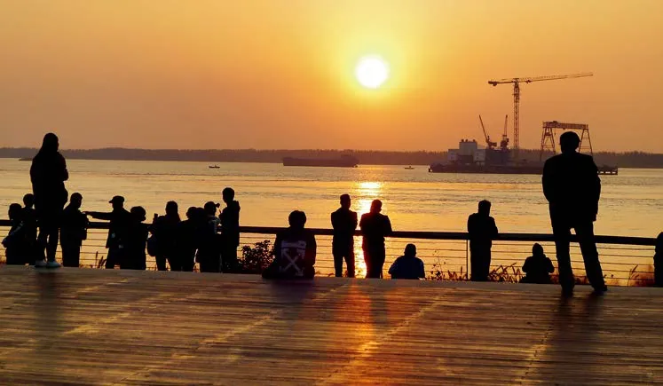
12 来自城市各处的游客齐聚于此,在夕阳的余晖洒向壮美的长江之时,共赏这一新落成的自然美景Visitors come from all over the city to celebrate the new nature and gain their first glimpse of the majestic Yangtze River at sunset
The flood protection levee facing the island’s new development is graded to form gentle sloping embankments for reforestation and wild flower meadow grassland. The aspect of these slopes is highly attractive when the setting sun illuminates grass inflorescence,particularly in the peak autumn period.

13 冬季,滞留池、生态草沟与落叶乔木营造出宁静而平和的氛围In winter, detention ponds, tall grasses and deciduous trees create a calm, reflective atmosphere to the park
Car parking uses permeable concrete paving,swales and rich plant mixes to ensure an ecological car park. Crushed stone paths lead through forest patches around lawns and up the levee. A long avenue from the entry plaza extends to the main pavilion overlooking the Yangtze River. The forked steel support columns of the shade pavilion echo the many forks in the Yangtze River which led to the formation of sedimentary islands. This ‘Y’ shaped fork is used in other balustrades,structures and path layouts throughout the park.
The permeable steel-decking to the forest boardwalk ensures resilience to seasonal flood events. In 2016 Nanjing experienced torrential rains and floods(the worst since 1998), but due to the robust design, the forest walkway structure withstood these floods which peaked at over 2m above the deck surface. Gates are fitted to the boardwalk to prevent access during flood season for health and safety.
Environmental impact and concerns
Against a backdrop of urbanisation and climate change, landscapes play an increasingly important role in the shaping of resilient cities. The challenge for this project was gaining acceptance of the naturalistic planting and biophilic design in the context of modern urban development. An important environmental design objective was to evoke the spontaneous vegetation with sophisticated planting combinations with extended seasonal interest. This required considerable understanding of plant ecology and performance to ensure that habitats continue to operate and stay robust despite threats from flooding, drought or urban pressures.
Planting and sowing arrangements were designed to challenge normal park standards by increasing the use of deciduous native trees, perennials and tall grasses in complex mixes. A high water table and extensive network of swales and raingardens create shallow vegetated depressions designed to capture stormwater runoff and allow the water to be stored in detention ponds. These natural filters improve water quality, provide wildlife habitat and become highlights of the ecological design.
Large swathes of Pink Muhly Grass (Muhlenbergia capillaris), from the grass family (Poaceae), is a feature plant suited for rain gardens and provides year-round colours. The green, needle-like foliage of muhly grass emerges during the spring and grows to mature size by summer, providing an excellent texture backdrop for perennials and late summer flowers. In the fall, muhly grass creates a spectacular floral display of light, airy flowers which appear like clouds. Its pink, purple or white flowers fade to tan or brown seed plumes, which hold up well from late fall through winter.The seed plumes are a food source for insects and birds, attracting beneficial insects such as butterflies and ladybirds (Coccinella spp.) whilst its clump forming habit provides a refuge for other wildlife.
Outside the flood protection levee a regenerative native forest mix was planted to establish a new generation of forest to succeed the relatively short lived stands of poplar that currently dominates the woodland. The method drew inspiration from the work of Japanese botanist and plant ecologist Dr. Akira Miyawaki. Plantations randomly distributed in clearings or at the edge of the existing forest provides a succession plan for the forest in 20-30 years’ time.
Project highlights
The success of the design is attributed to the strong collaboration between the government, client, design and specialist consultants, engineers and contractors. Phase one highlights include the naturalistic and ecological planting, low impact design and sponge city features. In October 2017 over 50,000 visitors visited the project over the course of several weekends to enjoy Pink Muhly Grass inflorescence. The blend of urban naturalistic and indigenous ecological planting attracts many local residents,families and photographers particularly in autumn when ornamental grasses bloom.The design approach has created a new benchmark for government of ficials seeking an environmental restoration precedent in an urban context. Recent recognition includes the 2018 IFLA AAPME Outstanding Award in the category of Wildlife,Biodiversity, Habitat Enhancement or Creation.
Lead Designer:AECOM
Local Design Company:Palm Eco-Town Development Co.,Ltd.
Client/Owner:Sino-Singapore Nanjing Eco Hi-Tech Island Dev Co.,Ltd.
AECOM Team:
Principle-in-charge:Wu Shun
Project Director:Lee Parks
Project Management:Fan Chuiyong, Hu Yan, Cao Zhen
Planting Designer:Liu Xiao Dan
Landscape Designer:Jiang Xin, Sun Ye, Agnes Soh, Charlie Gu, Kuo Singning, Jonathan Corbett, Chen Jing
Graphic Designer:Jin Yan, Luo Jie
Architecture:Michael Sangalang
Water Specialist:Xu Junjun, Cao Zhe
Ecologist:Shouling Chen, Xiong Sidun, Shirley Hu, Lizzie Li, Min Yuan
Landscape Contractor:Southeast University Architects and Engineers Co.,Ltd.
Lighting Designer:Nanjing Street Light Engineering Co.,Ltd.
Photography Credit:Lee Parks, Wu Hui, Yu Xiaokun, Tang Zhenyang
Author:Lee Parks, Jiang Xin
(Editor / LIU Yuxia)
(编辑/刘玉霞)
猜你喜欢
今日农业(2022年3期)2022-06-05
鸭绿江(2021年17期)2021-11-11
保健医苑(2021年7期)2021-08-13
今日农业(2021年3期)2021-03-19
青年歌声(2020年11期)2020-11-24
学生天地(2020年36期)2020-06-09
小学科学(学生版)(2020年5期)2020-05-25
天津诗人(2017年2期)2017-11-29
天津诗人(2017年2期)2017-11-29
旅游(2016年2期)2016-02-04
