
Rupture process of the January 8, 2022, Menyuan M 6.9 earthquake
2024-01-08 06:00XunWangCuipingZhao
Earthquake Research Advances 2023年4期
Xun Wang, Cuiping Zhao
Institute of Earthquake Forecasting, China Earthquake Administration, Beijing, 100036, China
Keywords:
ABSTRACT After the occurrence of destructively strong earthquakes, rapid acquisition of the source rupture process can provide important reference information for post-earthquake disaster relief and aftershock trend determination.An M 6.9 earthquake occurred in Menyuan County,Qinghai Province on January 8,2022.The epicenter is located in the seismic gap in the middle section of the Haiyuan fault belt.Such a typical strong earthquake was taken as an example to investigate the rupture process of strong earthquakes.Three days after the earthquake, the InSAR(Interferometric Synthetic Aperture Radar)coseismic deformation field was obtained by Sentinel radar,indicating that the surface ruptured obviously.The southern block of the earthquake faces towards the satellite about 95 cm along the LOS (line of sight) direction, and the northern block is away from the satellite by ~ 74 cm, consistent with the characteristic of left-lateral strike-slip motion.In this study, InSAR coseismic deformation data and farfield waveform data were used to jointly invert the earthquake rupture process, and a four-segment finite fault model was constructed by referring to the surface deformation.The inversion results show that the focal depth of the Menyuan earthquake is about 7 km,and the strike of the seismogenic fault is 89.0°,104.0°,119.0° and 131.0°from west to east, respectively.It is a high-dip left-lateral strike-slip earthquake event lasting about 14 s.The rupture propagation mode is a bilateral extension.The maximum slip along the fault is about 380 cm, and the seismic moment magnitude is 6.7.The surface rupture length is about 24 km, which is consistent with that measured in the field survey.The detailed seismic source model can provide basic data for the aftershock trend determination and seismic risk analysis of the adjacent active faults.
1.Introduction
Obtaining detailed information on the temporal and spatial processes of seismic sources is an essential goal of seismological research (Zhao et al., 2010; Wang et al., 2022).After the occurrence of strong earthquakes, rapid acquisition of focal mechanism solutions, source rupture processes,and accurate positioning of aftershock sequences can provide key information for post-earthquake disaster relief,seismogenic structure determination, and aftershock trend prediction (Shi and Cao, 2010;Zhang et al.,2012).
On January 8, 2022, anM6.9 earthquake occurred in Menyuan County, Qinghai Province.The epicenter (101.26°E, 37.77°N) (China Earthquake Networks Center(CENC))is located in the seismic gap in the middle part of the Haiyuan fault belt (Fig.1), which is one of the important active faults in the northeastern margin of the Qinghai-Tibetan Plateau, and historical strong earthquakes are very active (Zhang et al.,2005;Jolivet et al.,2013).The seismogenic faults of this earthquake are the western segment of the Lenglongling fault and the eastern segment of the Tuoleshan fault.The Lenglongling fault has a left-lateral strike-slip nature, with a slip rate reaching up to 6.6 ± 0.3 mm/yr (Jiang et al.,2017).The latest earthquake with a magnitude above 6 on this fault is the MenyuanM6.4 earthquake in 2016,which is located~60 km east of theM6.9 earthquake (Luo and Wang, 2022).The epicentral area of the Menyuan earthquake has a high altitude and is sparsely populated.The earthquake did not cause many casualties but resulted in serious economic loss in the Qinghai Province and Gansu Province.The loss mainly comes from the damage or collapse of buildings, tunnels, and other infrastructures.Notably, it was reported that the Lanzhou-Xinjiang high-speed railway suffered severe damage(Xue et al., 2022).After the earthquake, multiple agencies immediately provided the focal mechanism solution, all suggesting that it was a strike-slip earthquake.Due to the demand for emergency scientific investigation, it is necessary to affirm whether the surface can produce an obvious coseismic rupture zone and to determine the size of the earthquake damage range.In this study, the real-time far-field waveform data were obtained from the global seismic network.With the supplement of InSAR data, the geometric shape of the seismogenic fault can be delineated more intuitively.Combined with the dominant resolution of waveform data and deformation data in time and space, a joint inversion-based layered crustal model was used to obtain more detailed information on fault rupture distribution of the Menyuan earthquake, which provides data basis for subsequent research on aftershock distribution or stress triggering.
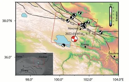
Fig.1.The geological background of the Menyuan M 6.9 earthquake.The red and white beach ball shows the focal mechanism solution of the main earthquake,the black and white beach ball marks the historical M > 5.5 earthquake since 1976 in the surrounding area (from GCMT).The red rectangle is the range of the InSAR image.TLSF: Tuoleshan fault, LLLF: Lenglongling fault, JQHF: Jinqianghe fault.
2.Data
The application of the finite fault model to study the rupture process of strong earthquakes is the main research method in this study (Wang et al., 2015).The far-field waveform data used were downloaded from the IRIS data management center,and 18 far-field P-wave waveforms and 24 SH-wave waveforms with high signal-to-noise ratio and uniform distribution along the azimuth were selected(epicentral distance is within the range of 30°< Δ < 90°) and filtered.The SAR data were obtained from ESA(European Space Agency,Table 1),and the pre-earthquake and post-earthquake images of the source area covered by the Sentinel radar were downloaded on January 11,three days after the earthquake.
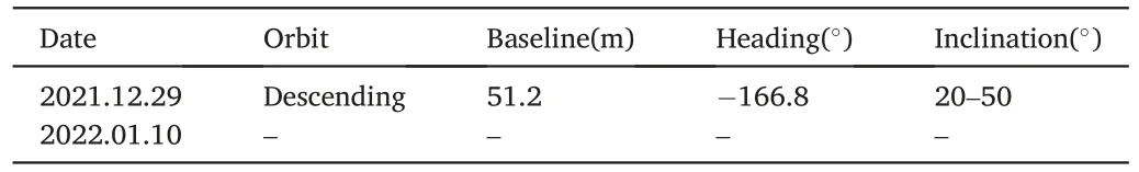
Table 1Sentinel-1 image parameters.
Due to the all-time and all-weather characteristics,InSAR can obtain continuous and complete surface deformation information.This technique is widely used in earthquake, volcano, and other geological research (Massonnet et al., 1993).In addition, the 12-day repeat orbit cycle of each Sentinel-1 satellite along with small orbital baselinesenables SAR interferometry (InSAR)coherent change detection applications such as the monitoring of surface deformations(Elliott et al.,2015).In this study,the GMTSAR open-source program(Sandwell et al.,2011,2013) was used for differential interferometry.Firstly, the precise orbit correction was carried out, and the external terrain data-SRTM3 DEM with a resolution of 3 arc seconds was introduced to remove the terrain effect.Then,Goldstein filtering was performed to reduce the noise effect,and the coseismic deformation field interferogram of the MenyuanM6.9 earthquake was obtained (Fig.2).The phase unwrapping uses the Snaphu module.Finally, the surface deformation field of the ground coordinate was obtained by geocoding.
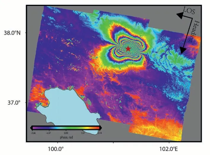
Fig.2.Coseismic deformation field of Menyuan M 6.9 earthquake from InSAR.The red star indicates the epicenter location.
The seismogenic fault of the MenyuanM6.9 earthquake has a nearly E-W strike.A complete and clear InSAR interference fringe pattern(Fig.2)has been obtained in the source area,showing a butterfly-wingshaped pattern.The boundary of the deformation zone is prominent,consistent with the Lenglongling fault zone.Furthermore,the size of the two sides is similar,indicating that the absolute value of deformation on both sides of the fault is similar.The stripes near the fault zone are more disordered, with the occurrence of decoherence.It is speculated that there are obvious surface fracture zones.The overall interferogram fringe is continuous and smooth, and the surface deformation quality of the source area obtained by phase unwrapping is high.Specifically,Sentinel-1 is a C-band radar,and a complete interference fringe corresponds to a LOS deformation of about 2.8 cm(Elliott et al.,2015).Considering that the Menyuan earthquake is dominated by pure strike-slip movement,the southern wall of the earthquake faces towards the satellite about 95 cm along the LOS direction,and the northern wall is away from the satellite about 74 cm along the LOS direction.These features are consistent with the left-lateral strike-slip motion characteristic of the earthquake.
3.Joint inversion of the source rupture process
The rupture information of strong earthquakes is critical for understanding the seismogenic structure and analyzing the corresponding seismicity(Zhao et al.,2010).Therefore,it is necessary to construct the source rupture model quickly and accurately to serve the earthquake emergency investigation.
The InSAR coseismic deformation field was used to extract the geometric shape and segmentation form of the seismogenic fault on the surface,mask the area with a low coherence coefficient,and resample the near-field displacement data in the source area.These steps reduce the amount of data and ensure the accuracy(Wang et al.,2018).Based on the focal mechanism solution,aftershock distribution(Zuo et al.,2023)and InSAR coseismic deformation field (Fig.3), a four-segment fault model was constructed.The fault is 42 km long and 18 km wide, and the strikes of faults from west to east are 89.0°,104.0°,119.0°,and 131.0°,respectively.A total of 189 sub-faults of 2 km×2 km were divided.The dip angles of the four fault segments were kept unchanged and all set to 86°.In this study, the far-field seismic waveform data and InSAR coseismic deformation data of this earthquake were used for joint inversion.Based on the layered crustal model, the simulated annealing nonlinear inversion method was employed to probe the seismic source process, for acquiring more detailed and accurate source rupture information of the Menyuan earthquake.
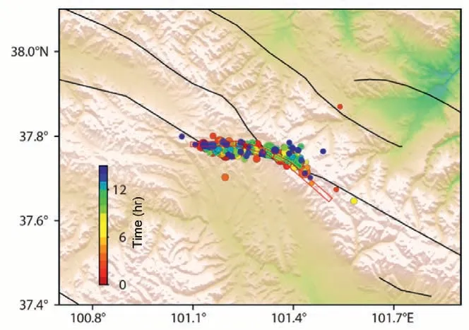
Fig.3.The surface projection of the fault model, the red line frame indicates the fault location,and the color dots indicate the distribution of aftershocks with different time durations.
In this study, the epicenter location was selected as 101.31°E and 37.81°N based on the epicenter information released by CENC.The crustal layered information of the Menyuan earthquake was extracted by Crust2.0(Bassin et al.,2000),and the layered medium model(Crust2.0)was further used to calculate the static displacement.According to the generalized ray principle, we calculated the far-field theoretical waveform.The nonlinear inversion of the source model was realized by the fast simulated annealing technique (Wang et al., 2018).The mathematical expression of the objective function is:
In Equa.(1),the first term on the right is the inversion term of the seismic waveform record,whichNWdenotes the number of seismic stations,fj(t)is the theoretical seismogram of thejstation, andoj(t) represents its observed waveform record.The second term is the InSAR coseismic displacement field data inversion term, whereare the radar LOS displacement field observations and synthetic theoretical values ofidata sampling points, respectively.The third constraint condition is the smoothing factor,which is used to control the physical continuity of the sliding displacement on the adjacent sub-fault element.w1,w2are the weight ratios of seismic waveform records and InSAR data in inversion.In the inversion process,the weight ratios of various types of data were given according to experience.The InSAR data of the Menyuan earthquake possess strong constraints on the inversion model,exhibiting good integrity and high accuracy.The corresponding weight ratio in the inversion can be increased.Finally,the optimal weight ratio combination was selected through multiple iterations.
The joint inversion results based on the four-segment fault model are shown in Fig.4.The Menyuan earthquake is a high-dip left-lateral strikeslip seismic event.The initial rupture point depth is about 7 km,and the rupture duration is about 14 s.The fault is a bilateral extended rupture.The length of the surface rupture zone is about 24 km,which is consistent with the field survey result.The maximum slip on the fault plane is about 380 cm, and the seismic moment release is 1.67e19 N-m (MW= 6.7).During the rupture slip inversion, the range of fault rupture velocity is limited to 2.0 km/s and 3.2 km/s.The range of the smoothing factor used during inversion is between 0.02 and 0.2,and the variations within this range have a minimal impact on the shallow slip characteristics.The smoothing factor is set to 0.1,and the fittings in the joint inversion model are satisfying.Fig.5 shows the result of far-field waveform fitting.It is prominent that the correlation between the fitted P-wave and S-wave is good.Fig.6 shows the observation value of the InSAR coseismic deformation displacement field, the theoretical value of LOS synthesized by the finite fault model, and their residuals.The overall fitting of the coseismic deformation field is better, and the residual values in most areas are less than 5 cm.
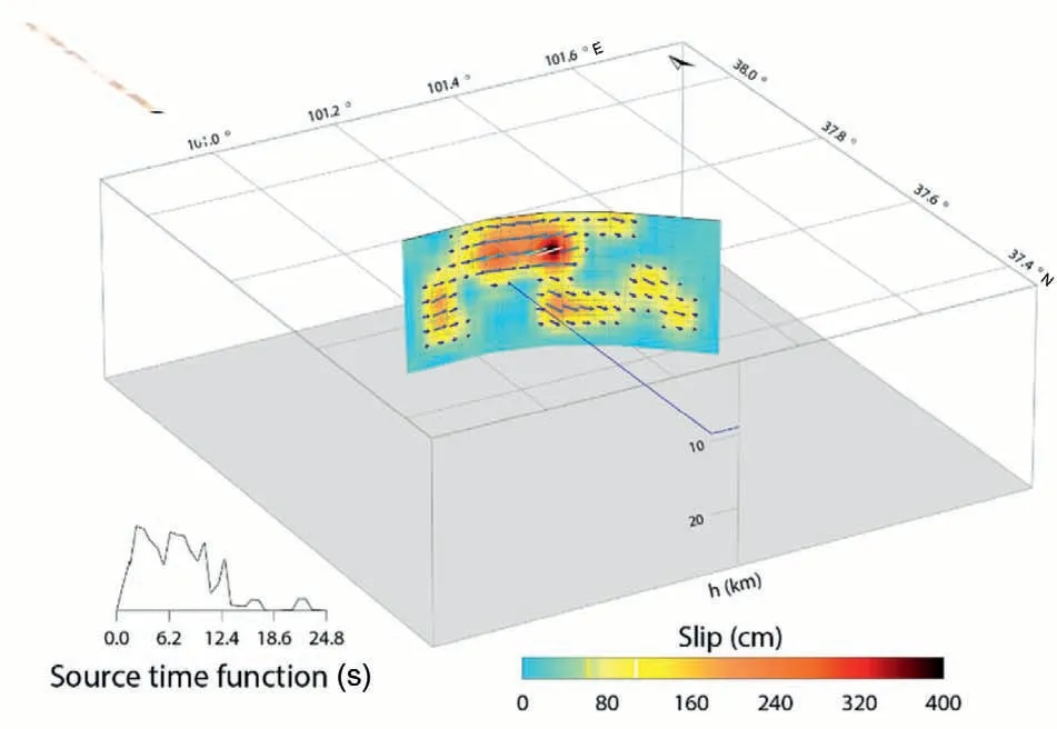
Fig.4.The 3D model of slip distribution on the fault surface.
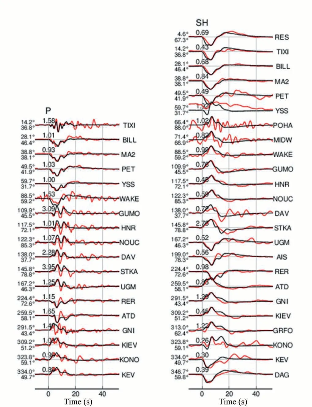
Fig.5.Comparison of waveforms.Red and black lines represent the observed and synthetic waveforms, respectively.Numbers on the left indicate the azimuth and epicentral distances of the stations.The number above each waveform is the amplitude ratio.
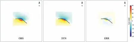
Fig.6.The InSAR observation and synthetic LOS theoretical values and their residuals, respectively.
4.Discussion and conclusions
For earthquakes with obvious surface rupture, the post-earthquake field survey data can better constrain the location and geometric shape of the seismogenic fault on the surface, thereby significantly improving the inversion efficiency and accuracy (Lin et al., 2009).The InSAR data may show decoherence at the near-fault region, and the displacement data near the fault zone can supplement the lack of InSAR data and improve the constraints on the inversion model (Li et al., 2022a).Liu et al.(2022)used Sentinel-1 and ALOS-2 SAR data from different orbits to compute the three-component surface displacement field generated by the Menyuan earthquake, and the results strongly agreed with field survey measurements.This suggests that if we directly use the three-component displacement values for seismic source modeling, the reliability and stability of the final model can be enormously enhanced.After the occurrence of the Menyuan earthquake, a great number of institutions such as ITPCAS (Institute of Tibetan Plateau Research, Chi-nese Academy of Sciences, private communication), IGPCEA (Institute of Geophysics, China Earthquake Administration, https://www.cea-igp.ac.c n/kydt/278809.html),IGCEA (the Institute of Geology, China Earth-quake Administration,https://www.eq-igl.ac.cn/kydt/info/2022/3 6614.html) and IEFCEA (Institute of Earthquake Forecasting, China Earthquake Administration) released the inversion results of the fault slip distribution of the earthquake in succession, all suggesting that the Menyuan earthquake is a left-lateral strike-slip earthquake event with high dip angle.However, there are some differences in the proposed source rupture models, mainly in the aspects of fault geometry, strike and dip angle, detailed fault slip distribution, surface rupture characteristics, etc.Such differences are related to the release time of the results, the completeness of the data,and the inversion strategy.Specifically, within a few hours after the earthquake, the far-field waveform data were used to invert the slip distribution of the fault plane using a single-plane fault model.The strike is consistent with the focal mechanism solution, and the rupture details,especially the surface rupture characteristics, are highly different(ITPCAS and IGPCEA).About 14 hr after the earthquake, the CENC released the relocation results of the aftershock sequence, and IEFCEA constructed a two-segment fault model based on the location of aftershocks to obtain the fault slip distribution model, showing that the length of the surface rupture zone is strongly consistent with the preliminary field investigation results measured in the next day after the earthquake.Three days after the earthquake, the ESA Sentinel radar provided some post-earthquake images.IGCEA obtained the geometry of the seismogenic fault and the surface displacement data from the InSAR coseismic deformation field and inverted the slip distribution of the fault plane, which is characterized by double fault ruptures.Zheng et al.(2023) established a rupture model through the inversion of ascending and descending InSAR data.The extremes of surface rupture in the model were close to actual observations.The length of the fault rupture is short,approximately 23 km.However,the constructed single-plane fault model exhibited some deviations when explaining observations near the fault.Furthermore, the surface rupture is highly scattered.In this study, the source model obtained by the joint inversion of waveform data and InSAR data is consistent with the research results of other studies (Li et al.,2022a,2022b;Lv et al.,2022).However,the situation presented by the four-segment finite fault model constructed in this study is more consistent with the actual observation.The continuous surface rupture scale of theoretical models reaches 24 km, which is extremely close to field observations, and the inversion result is stable.Therefore, the detailed information on earthquake rupture can be better constrained by combining the superior resolution of various data(Delouis et al.,2010),which can provide reliable basic data for the study of aftershock trend determination,stress triggering of surrounding active faults and regional risk analysis(Hardebeck,2004;Hainzl et al.,2010;Shi and Cao,2010).
The InSAR coseismic deformation field of the Menyuan earthquake shows that the earthquake caused an obvious rupture zone on the surface.The LOS direction of the southern wall of the earthquake was lifted by about 95 cm,and that of the northern wall was settled by about 74 cm,which conforms to the left-lateral strike-slip motion characteristics.Based on the InSAR deformation field, a finite fault model with strike change was successfully constructed.The strike of the seismogenic faults is 89.0°, 104.0°, 119.0°and 131.0°from west to east, respectively.We further employed the InSAR coseismic deformation data and far-field waveform data to jointly invert the rupture process of the Menyuan earthquake,revealing an approximately 7 km source depth,indicative of a high-dip left-lateral strike-slip earthquake event with a duration of about 14 s.In addition, the rupture propagation mode is bilateral expansion.The maximum slip on the fault is about 380 cm, and the seismic moment magnitude is 6.7.In the joint inversion results, the surface rupture length is about 24 km, which is consistent with the measurements in the subsequent field investigation (Pan et al., 2022;Yuan et al.,2023).
Overall,within a few hours after the earthquake,a finite fault model can be constructed by referring to the focal mechanism solution, aftershock relocation, and the regional geological setting, and then the farfield waveform data can be used to quickly invert the rupture process of strong earthquakes, providing primary references for earthquake emergency work.The further use of InSAR and other observation data for joint inversion research is an important means to effectively obtain a more accurate and detailed source rupture model.
Declaration of competing interest
The authors declare that they have no known competing financial interests or personal relationships that could have appeared to influence the work reported in this paper.
Author agreement and acknowledgment
The contents, methods, procedures and basic requirements of the relevant technical methods mentioned in this paper are from the monographGuide to Seismic Scientific Investigation.The far-field waveform data were provided by IRIS, and the SENTINEL-1A image data were provided by the European Space Agency (ESA).The figures in this article were generated using GMT software.This study was supported by the Project of Basic Scientific Research Foundation of the Institute of Earthquake Forecasting, China Earthquake Administration(CEAIEF2022030202), the 2023 Earthquake Tracking Project of CEA(2023010127).
 Earthquake Research Advances2023年4期
- Earthquake Research Advances的其它文章
- Rapid report of seismic damage to hospitals in the 2023 Turkey earthquake sequences
- Seismicity and seismogenic mechanism of the MS 6.0 Luxian earthquake on September 16, 2021
- Propagation of crust deformation anomalies related to the Menyuan MS 6.9 earthquake
- Trade space for time for inspecting an earthquake cycle by modern seismological observation:The central-southern part of the Sichuan-Yunnan rhombic block
- Earthquake geochemical scientific expedition and research
- Introduction to the recently published treatise entitled A Guidebook to Earthquake Scientific Investigation