
Earthquake geochemical scientific expedition and research
2024-01-08 06:00ChngLuXiohengZhouZhiChenZhofeiLiuLeHuFengxiSunGiovnniMrtinelliYingLi
Earthquake Research Advances 2023年4期
Chng Lu, Xioheng Zhou, Zhi Chen, Zhofei Liu, Le Hu, Fengxi Sun,Giovnni Mrtinelli, Ying Li,*
a Key Laboratory of Earthquake Prediction, Institute of Earthquake Forecasting, China Earthquake Administration, Beijing, 100036, China
b State Key Laboratory of Geological Processes and Mineral Resources,School of Earth Science and Resources,China University of Geosciences(Beijing),Beijing,100083,China
c INGV-National Institute of Geophysics and Volcanology Dept. of Palermo, Palermo, 90146, Italy
Keywords:
ABSTRACT Large earthquakes can cause both casualties and economic losses, but they also provide invaluable opportunities for earthquake scientific research.Geofluids, due to their wide distribution, sensitive response to underground conditions, and ease of observation, are widely applied in field investigations after earthquakes.Analyzing the origin of fluids,energy transfer processes,temperature/pressure conditions,and the spatial-temporal evolution of geofluids can provide valuable information concerning the mechanism of earthquake precursor anomalies,shortterm prediction methods, identification of the seismogenic faults, determination of earthquake risk, and the environmental impact of post-earthquake fluids.This article details post-earthquake scientific expeditions and research on fluid geochemistry in China and abroad, aimed at providing ideas and guidance for future scientific expedition work and geochemistry-related earthquake studies.
1.Introduction
China has a long history of earthquake scientific research since the Republic of China era(Gao,2021).Over the past half-century,along with the development of economy and science & technology, and increasing demand for earthquake prevention and disaster reduction, abundant scientific expeditions and research works have been performed on earthquakes throughout China over the past half-century,such asMS8.1 Kunlun earthquake in 2001 andMS8.0 Wenchuan earthquake in 2008.These works have obtained good scientific insights and practical help.Therefore, after 2008, China Earthquake Administration organized systematic scientific expeditions and research in many large earthquakes likeMS7.0 Lushan earthquake,MS6.5 Ludian earthquake,MS7.4 Madoi earthquake, andMS6.8 Luding earthquake (Guidelines for Earthquake Scientific Investigations, 2022).
The pregnancy and occurrence of earthquakes involve underground material migration, energy release and stress change (Lu et al., 2022).Geofluids are widely used in the study of short-term earthquake monitoring and seismogenic evolution processes because they can objectively and sensitively respond to the stress and strain state in the crust (Li et al., 2022).Earthquake geochemical studies usually include:setting up a fluid geochemical observation network in the epicenter and related tectonic areas, obtaining fluid geochemical observation data of the fault zone analyzing the variation of geochemical characteristics of the tectonic zone before and after the earthquake (Zhou et al., 2016);mapping the spatial and temporal geochemical characteristics of the region (Li et al., 2022); analyzing the intensity of fluids release from the fault zone in the region (Caracausi et al., 2022); combined with the pre-earthquake observation data,determine the source of geofluids in the earthquake area before and after the earthquake(Martinelli et al.,2017);discussing the change of water-rock reaction degree (Skelton et al.,2019); and giving the opinion of short-range prediction of earthquake risk in the epicenter and related tectonic area(Lu et al.,2021a,b).
This paper presents the earthquake geochemical scientific expedition and research undertaken by the geochemistry team of the “Institute of Earthquake Forecasting, China Earthquake Administration” in recent years.It also reviews related work in China and abroad.The study focuses on fluid geochemistry related to earthquakes, including main and trace ions and stable isotopes in springs,concentrations and fluxes of soil gases(e.g., Rn, Hg, CO2, CH4, H2) across faults, etc.In summary, this paper outlines the methods and fundamental concepts of earthquake scientific expedition and research, as well as how to discuss the evolutionary process of pregnant earthquakes and the judgment of earthquake risk trends.This provides a theoretical basis for future earthquake geochemical scientific expeditions and research.
2.Theory and methods
2.1. Fluid geochemistry of hot (cold) springs, geothermal wells and sandblast bubble holes
Geochemical methods were used to investigate the connection between fluid coupling in the deep and shallow of the active fault zone and the seismicity of the fault zone by collecting groundwater samples near the epicenter (e.g.Dobrovolsky et al., 1979) and overflow gas.The relationship between fluids and earthquakes has two aspects:The first is the passive effect of fluids on earthquakes, where the occurrence and progression of earthquakes cause changes in fluid composition that are manifested as the precursor response of earthquakes.The second is the positive effect of fluids, where earthquakes are directly influenced by fluid participation i.There is a long history of research on fluid geochemistry (Stumm and Morgan, 1996; Zheng et al., 2022), and the main aspects related to earthquakes include the following:
(a) Determining the source and release intensity of fluids, deepshallow coupling relationships, spatial and temporal variations,analyzing anomalous changes in deep fluid precursors, establishing a comprehensive fluid migration model, and discussing the role played by fluids in the earthquake pregnancy process.
(b) Discussing the degree of water-rock interaction; the weakening effect of fluids on rocks and promoting the growth and development of fractures.
(c) Assessment the water quality of the spring and drinking water,and give advice on drinking.
Sample collection, analysis and pretreatment and preservation are referred to(e.g.,Lu et al.,2021a,b;Liu et al.,2022a)
2.2. Investigation of earthquake rupture zones and cross-fault degassing characteristics
Based on field survey and related consultations, the location of the active fault zone exposed near the epicenter was searched, and the soil gas measurement profile was set up across the fault (Fig.1).By investigating gas release intensity before and after the earthquake, the correlation between gas release intensity and rupture scale in the earthquake rupture zone is given to provide information for earthquake intensity investigation.We also assessed the emissions of toxic and radioactive gases released from earthquake rupture areas, which served as an environment baseline study.Furthermore, the analysis of degassing intensity was used to determine the fault activity, with implications for seismic risk analysis and judgment.Lastly, changes in soil gas concentration pre- and post-earthquake were compared, providing a detailed examination of the process of earthquake pregnancy and evolution.
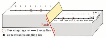
Fig.1.Schematic diagram of the cross-fault soil gas measurement profile(Li et al., 2022).
The method of soil gas measurement and the formula of flux calculation refer to(e.g.,Chen et al.,2018;Zhao et al.,2022)
3.Examples
In recent years, significant progress has been made in earthquake scientific expeditions and research both at home and abroad.This paper provides an overview of typical domestic and international work on earthquake geochemical scientific expeditions and research, which employs various research methods to obtain different types of results.
3.1. Wenchuan MS 8.0 earthquake
On May 12, 2008, a catastrophic earthquake with a magnitude ofMS8.0 devastated Wenchuan County, located in Sichuan Province.The earthquake triggered a global response with numerous research agencies from both China and other countries participating in scientific expeditions and research towards earthquake prevention.Geochemical-related interventions were also implemented as part of the scientific effort.
1I; The Zhao and Chen team from Peking University,in collaboration with the Institute of Geology and Geophysics, Chinese Academy of Sciences, conducted a continuous collection of hot spring water samples(Zhougongshan Spring) in the southern margin of the Longmenshan Fault Zone.The sampling was carried out between January and May 2009 following the earthquake:The hydrogen isotopes(δD)in the spring water responded significantly to the aftershocks of magnitude 4–5 that happened in the same zone (Fig.2).Specifically, δD value gradually decreases from the baseline, experienced an increment after the earthquake, and then gradually returned to the ordinary background value.Additionally, the intensity of the response was found to be more pronounced for stronger earthquakes.Collectively, this study demonstrates that analyzing hot spring water samples collected continuously from seismic zones following an earthquake can serve as a short-term prediction for earthquakes with magnitudes of 5.0 or above (Zhao et al.,2011).
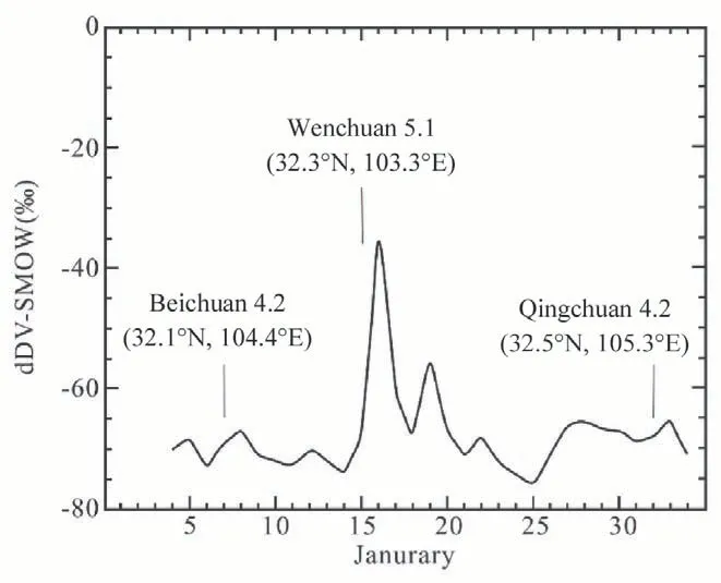
Fig.2.Hydrogen isotope value variation with time for Zhougongshan hot spring water sample(modify by Zhao et al., 2011).
I2I; Zhou's team at the Institute of Earthquake Forecasting, China Earthquake Administration, conducted a study based on 10 soil gas profiles(334 soil gas concentration measurement points and 70 soil gas flux measurement points) along the earthquake rupture zone resulting from the Wenchuan earthquake in June 2010.The measurement terms include Rn, CO2and Hg.The results of soil gas concentration indicated that the Rn concentration in the northern section of the rupture zone was high, with a pollution level of 4 according to GB 50325-2001 standards.The CO2concentration showed no significant safety concerns.An average geo-accumulation index (Igeo) of Hg in the soil was below pollution levels and reached moderate to severe pollution in the epicenter (Fig.3).Soil gas flux results indicated that the maximum value of Rn flux (1976 mBq m-2s-1) with the total degassing of CO2and Hg of 0.57 Mt year-1and 688.19 g year-1was found at the northern of the rupture zone.This study suggests that soil gas concentrations and fluxes be considered in possible risk area studies to inform potential risk management strategies(Zhou et al., 2016)

Fig.3.Contour maps of environmental assessment of soil gas CO2, Rn and Hg concentrations along the rupture zone of Wenchuan MS 8.0 earthquake.
In addition, the team conducted soil gas concentration measurements in the WenchuanMS8.0 earthquake rupture zone, specifically evaluating the H2concentration.Their found that the average concentration of H2in soil gas spatially decreased from Yingxiu (epicentral area) to Nanba.Moreover, the magnitudes of the H2 concentration anomalies exhibited a significant drop in magnitude over time (Zhou et al., 2017).
3.2. Madoi MS 7.4 earthquake
On 22 May 2021, an earthquake ofMS7.4 struck Madoi County,Qinghai Province, the largest earthquake of magnitude in China since the 2017 JiuzhaigouMS7.0 earthquake.The earthquake created surface rupture zone that extended near NWW-SEE and covered a distance of about 70 km.This rupture zone contained tension fissures,sand lique-faction, sandblasting and water bubbling phenomena.Additionally, cold springs emerged near the surface rupture zone (Fig.4).A day following the earthquake, 21 water chemistry samples were taken.These samples included water bubbling from the earthquake rupture zone and the hot springs near the East Kunlun fault zone, as well as 4 sandy soil samples from post-earthquake sandblasting and water bubbling sites.
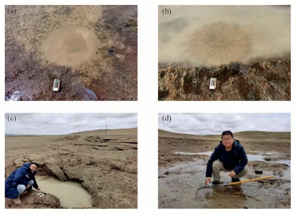
Fig.4.Map of samples collected in the surface rupture zone after the MS 7.4 earthquake in Madoi.(a) (b) Postearthquake sand liquefaction map, scale 12 × 28 cm; (c), (d) Field sample collection map.
The geochemical characteristics and sources of sandblast bubbling and cool springs around the surface rupture zone and hot springs near the Eastern Kunlun fault zone are discussed and the differences are compared, with discussion and data referenced from Lu et al.(2021a).Conclusions that can be drawn include: The sandblast bubbling and cool springs near the surface rupture zone from shallow groundwater and mixing with a surrounding lake (river); From the water temperature, γNa/γCl, and elemental content of deep material, the hot spring water within the Eastern Kunlun fault zone circulates at a deeper depth and can carry deep elements upward, appearing in the more active sections of the fault zone.In the future, it is important to carry out hydrogeochemical monitoring of hot springs within the Eastkunlun fault.Additionally, anomalousδD values (δD ¼=-59‰) were observed in MDW9 near the epicenter location (18 km).
3.3. Luxian MS 6.0 earthquake

Fig.5.Spatial distribution of soil gas H2 (a) and Rn (b) concentrations in the epicenter and nearby areas of the Luxian earthquake.
In summary, a NW fault zone may be present near the epicenter of the Luxian earthquake, but the scale of the fault is weak.Therefore, the Huayinshan fault may still be the main tectonic control of regional earthquake activity, and the occurrence of the Luxian earthquake is not related to the tectonic activity of large NW-trending faults in the Sichuan Basin, but may be related to the release of local stresses in the background of strong regional tectonic compression, and the earthquake promoted the release of gas from the shallow NW-trending occult fault zone near the epicenter.
3.4. Luding MS 6.8 earthquake
On September 5, 2022, at 12:52, anMS6.8 earthquake occureol in Luding County, Ganz^e, Sichuan Province, at a depth of 16 km.Based on the soil gas profiles measured in 2019 (Sun et al., 2021) and 2021 (Liu et al., 2022b) at the Xianshuihe fault, the Anninghe fault, and the Zemuhe fault, 10 soil gas profiles were selected from the north to south, including three profiles near the epicenter (Fig.6).This study aims to compare soil gas concentration data taken at the same location profiles, analyze degassing variations before and after the earthquake, investigate the process and genesis of the changes of degassing, and determine the present-day activity intensity of the fault zone.In addition, changes in gas concentration are utilized to assess the strength of the Anninghe fault zone s activity, which provides a basis for judging earthquake risk ten’dency.The historical data and measurement results are shown in Fig.7.
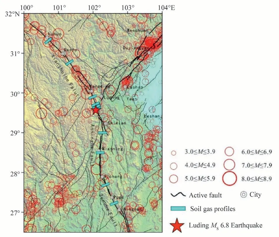
Fig.6.Geological map and soil gas measurement profile location of the Luding MS 6.8 earthquake.
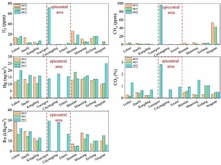
Fig.7.Average values of soil gas concentrations of Rn, Hg, CO2, CH4 and H2 measured in each section of the Xianshuihe Fault, Anninghe fault and Zemuhe fault.
The Yanzigou, located near the epicenter, exhibited the highest concentrations of Rn, CO2, H2, and CH4in the soil gas profiles.Stress release caused by the earthquake led to the formation of rock fractures,which significantly contributed to the increased concentration of soil gas.However, the gas concentrations in Caiyangping town (the area of severe earthquake hazard) and Ertaizi Mountain South (the area of suspected surface rupture zone outcrop) do not show remarkably high gas concentration values.Nevertheless, Rn, CO2and Hg levels elevated moderately across the fault profile, even in areas with lower concentrations of H2and CH4,due to the effects of temperature, topography, and precipitation(lower concentrations of H2and CH4).
Spatially, the H2concentration exhibits higher values from north to south in the Anninghe fault zone compared to the Xianshuihe fault zone.The highest CH4concentration occurred in the profile of Ningnan County(Anninghe fault), while Hg and CO2levels were similar in both zones,with the Anninghe fault averaging slightly higher.The Rn value of the Xianshuihe fault is slightly higher than that of the Anninghe fault zone,which is related to the lithology and fault activity.The decay of radioactive elements in the granite and the higher fault activity are the reasons for the higher Rn value of the Xianshuihe fault(Table 1).
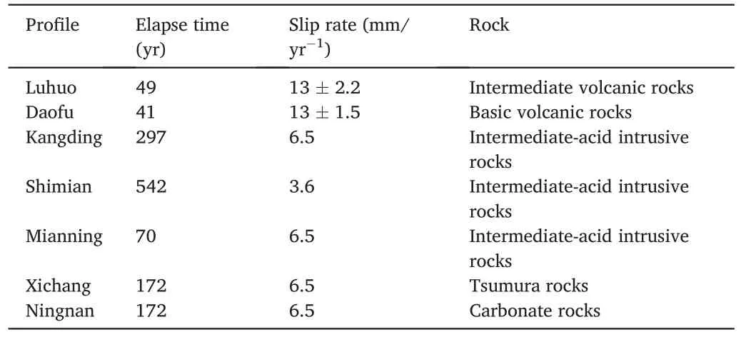
Table 1Geological information related to the Xianshuihe fault, the Anninghe fault and the Zemuhe fault.
Overall, the highest values of soil gas concentration were found in Yanzigou near the epicenter,and the average value of the Anninghe fault zone was higher than that of the Xianshuihe fault zone.In the future,enhancing fluid geochemical monitoring within the Anninghe fault zone is necessary.The Xianshuihe Fault is stable across all its segments, and the Yanzigou profile remains an ideal location for continuous soil gas monitoring due to its location at the intersection site of the secondary faults of the Xianshuihe Fault,influenced by this earthquake.
After summarizing the examples of post-earthquake geochemical research in fault zone gas emissions, earthquake risk assessment, identification of faults,and earthquake prediction mechanisms, the ultimate goal of earthquake research is underscored as predicting earthquakes to reduce losses, although it remains a difficult proposition.The current mechanisms remain unclear,but they include water-rock reactions,deep magma upsurge,stress changes,mixing of different fluids,and alterations in fluid pathways.These factors affect the fluid status before and after an earthquake.Therefore,understanding these fluid states will require more in-depth research and technical updates.
3.5. Abroad earthquake scientific expedition and research
Several countries, including Italy, Germany,Russia, Japan, the USA,Slovenia, and Iceland, have conducted seismic geochemical scientific studies.Currently collected papers typically involve long-term and continuous monitoring to capture anomaly information, followed by discussions on the genesis mechanism and prediction methods of the anomalies.However,more extensive and in-depth research is required.
A geochemical observation network was established in the northern Apennines (Italy) in the 1880s, providing seismic activity records spanning December 1988 to January 1989.The subsequent post-earthquake analysis revealed that gas components(CH4,CO2,N2,etc.)in springs and natural overflow of Rn222are clear precursor information(Martinelli and Ferrari, 1991), thus forming the basis for the selection of earthquake observatory indicators.In a similar study, long-term Rn and meteorological observations as well as hydrological observations conducted in Vogtland (seismically active region) in southeastern Germany, found a significant correlation between Rn and earthquake activity in the region,thought to be caused by earthquakes altering the opening or closing of fractures.They also found changes in mantle source CO2(Heinicke et al.,1995).Following theM7.3 earthquake in Kumamoto (Japan) on April 16, 2016, Sano's team collected 117 samples of commercially bottled mineral water from deep well water near the epicenter area,discoveringvaried anomalous δ18O values (0.51‰ & 0.38‰) or three months preceding and following the earthquake.These results suggest that the rapid crustal deformation caused by the earthquake increased the microfracture and fresh surface of the aquifer rocks, intensified the oxygen isotope replacement reaction (Sano et al., 2020), and similar research was conducted concerning the 1995 Hanshin (Kobe)M7 earthquake in Japan (Tsunogai and Wakita,1995).Other long-term monitoring works include studying fluid geochemical anomalies observed from 1977 to 1993 via continuous fluid geochemical observations in Kamchatka,Russia(Bella et al.,1998),examining geothermal fluids in Bled,Zatolmin in northwestern Slovenia and Rogaˇska in eastern Slovenia in 2001(Zmazek et al.,2002),analyzing the stable isotopes ratios and dissolved element concentrations of groundwater taken from a borehole in northern Iceland between 2008 and 2013 (Skelton et al., 2014); and monitoring of helium and carbon isotopes in the western Eger Rift are(Czech Republic),from 2000 to 2016(Bräuer et al.,2018).
现代商场最大的特点就是分区较多,楼层也在逐渐增加。对于很多方向感不好的顾客来说,在商场中很容易失去方向,且需要相应服务时不能快速找到其位置。为方便客户,同时提升商场销量,需要在重点位置进行方向标记[3]。并在最显眼的位置为客户提供商场平面图。在建造过程中,在商场内部标明区域的大致方向,且每个区域要标记上出口方向,保证商场内部发生意外时,客户能够根据标记有序快速的撤离。
In conclusion, several countries pursued earthquake geochemical scientific expeditions and research, with a focus on studying anomaly genesis mechanism and discovering earthquake prediction methodsaspects that we should focus on learning from.
4.Conclusions
Fluids are active components of the Earth's interior, their chemical and isotopic composition and emission intensity are closely related to surrounding environments such as underground temperature and pressure,geological background,and sources of materials,and are significant research objects for studying earthquake activity.Hence, fieldwork and research work carried out after the earthquake or using continuous observation processes to capture information on pre-, co-, and postearthquake geochemical anomalies can help understand the mechanism of anomaly genesis, identify earthquake-generating faults, investigate gas contribution to the environment after the earthquake, and judgment of earthquake risk trends.In summary, earthquake fluid geochemistry scientific expedition and research are highly effective and indispensable.
Irrespective of the method used in earthquake research, the main objective remains to reduce casualties and property damage,particularly in China, which experiences intra-plate earthquakes frequently.Therefore,the focus of the research is to clearly comprehend the mechanism of earthquake anomaly genesis,earthquake pregnancy and evolution and to enhance the effectiveness of fluid geochemical short-term prediction.According to domestic and international studies, long-term and highdensity continuous geochemical observations are necessary for effective research.
Declaration of competing interest
The authors declare that they have no known competing financial interests or personal relationships that could have appeared to influence the work reported in this paper.
Author aggreement and Acknowledgement
I would like to declare on behalf of my co-authors that the work described was original research that has not been published previously,and is not under consideration for publication elsewhere,in whole or in part.All the authors listed have approved the manuscript that is enclosed.
This work was supported by the National Nature Science Foundation of China [(Grant number 42073063, 41402298)], Central Public-interest Scientific Institution Basal Research Fund (CEAIEF2022060101).Special Fund of the Institute of Earthquake Forecasting(2021IEF0101),and United Laboratory of High-Pressure Physics and Earthquake Science(Grant number 2022HPPES01).This work is a contribution to IGCP Project 724.
Aims & Scope:
The aim ofEarthquake Research Advancesis to improve our understanding of earthquake physics,expand our ability to observe earthquake-related phenomenon and improve our mitigation of seismic hazards.To achieve that goal, the journal publishes original research articles focused on all aspects of earthquake studies.Topics covered include, but are not limited to:
•Tectonic environments and structures of the Earth, especially, seismogenic fault zones
•Long- and short-term behaviour of fault zones
•Laboratory, fi eld, and numerical experiments on the physical process of earthquakes
•Primary and secondary hazards associated with earthquakes
•Forecasting and mitigation of seismic hazards
The following subjects may be involved: geology, seismology, geodesy, rock physics and computer science.The long-term goal of this journal is to become an internationally-recognised English-language journal in earthquake science.
猜你喜欢
新传奇(2022年25期)2022-11-05
青少年科技博览(中学版)(2021年9期)2021-12-21
鸭绿江·下半月(2020年2期)2020-04-07
鸭绿江·下半月(2020年1期)2020-03-23
鸭绿江·下半月(2019年12期)2019-10-21
英语学习(上半月)(2019年9期)2019-10-10
读者(2019年2期)2019-01-05
中国特种设备安全(2018年10期)2018-12-18
中学生天地(A版)(2017年9期)2017-09-18
华东师范大学学报(自然科学版)(2017年1期)2017-02-27
 Earthquake Research Advances2023年4期
- Earthquake Research Advances的其它文章
- Rapid report of seismic damage to hospitals in the 2023 Turkey earthquake sequences
- Rupture process of the January 8, 2022, Menyuan M 6.9 earthquake
- Seismicity and seismogenic mechanism of the MS 6.0 Luxian earthquake on September 16, 2021
- Propagation of crust deformation anomalies related to the Menyuan MS 6.9 earthquake
- Trade space for time for inspecting an earthquake cycle by modern seismological observation:The central-southern part of the Sichuan-Yunnan rhombic block
- Introduction to the recently published treatise entitled A Guidebook to Earthquake Scientific Investigation